| Name
|
Size
|
Creator |
Creation Date
|
Last Modification Date
|
Labels |
Attached To |
|
PNG File logo-rgb-l.png |
12 kB |
Michaela Seewald |
Feb 20, 2020 14:21 |
Feb 20, 2020 14:21 |
|
Page: Project Team
|
|
JPEG File Deltares_logo_D-blauw_CMYK.jpg |
75 kB |
Michaela Seewald |
Feb 20, 2020 14:21 |
Feb 20, 2020 14:21 |
|
Page: Project Team
|
|
PNG File image2020-2-19_17-3-30.png |
120 kB |
Michaela Seewald |
Feb 19, 2020 16:03 |
Feb 19, 2020 16:03 |
|
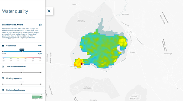
Page: Product Sheet: Water Quality
|
|
PNG File image2020-2-19_17-2-14.png |
376 kB |
Michaela Seewald |
Feb 19, 2020 16:02 |
Feb 19, 2020 16:02 |
|
Page: Product Sheet: Vegetation Mapping
|
|
PNG File image2020-2-19_17-1-18.png |
112 kB |
Michaela Seewald |
Feb 19, 2020 16:01 |
Feb 19, 2020 16:01 |
|
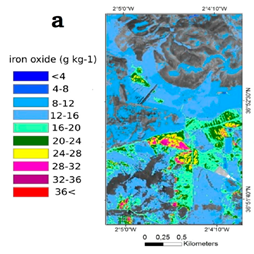
Page: Product Sheet: Soil structure and chemistry
|
|
PNG File image2020-2-19_17-0-46.png |
239 kB |
Michaela Seewald |
Feb 19, 2020 16:00 |
Feb 19, 2020 16:00 |
|
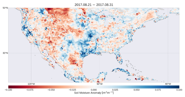
Page: Product Sheet: Soil Moisture
|
|
PNG File image2020-2-19_16-59-58.png |
440 kB |
Michaela Seewald |
Feb 19, 2020 15:59 |
Feb 19, 2020 15:59 |
|
Page: Product Sheet: Protected Areas
|
|
PNG File image2020-2-19_16-59-27.png |
356 kB |
Michaela Seewald |
Feb 19, 2020 15:59 |
Feb 19, 2020 15:59 |
|
Page: Product Sheet: Orthophoto Map
|
|
PNG File image2020-2-19_16-58-47.png |
267 kB |
Michaela Seewald |
Feb 19, 2020 15:58 |
Feb 19, 2020 15:58 |
|
Page: Product Sheet: National Monuments
|
|
PNG File image2020-2-19_16-58-11.png |
520 kB |
Michaela Seewald |
Feb 19, 2020 15:58 |
Feb 19, 2020 15:58 |
|
Page: Product Sheet: Lithology and Surficial Geology Mapping
|
|
PNG File image2020-2-19_16-57-35.png |
337 kB |
Michaela Seewald |
Feb 19, 2020 15:57 |
Feb 19, 2020 15:57 |
|
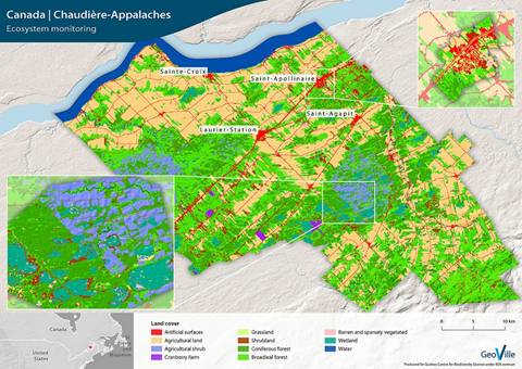
Page: Product Sheet: Land Use Mapping
|
|
PNG File image2020-2-19_16-56-52.png |
390 kB |
Michaela Seewald |
Feb 19, 2020 15:56 |
Feb 19, 2020 15:56 |
|
Page: Product Sheet: Land progressively rehabilitated
|
|
PNG File image2020-2-19_16-56-12.png |
390 kB |
Michaela Seewald |
Feb 19, 2020 15:56 |
Feb 19, 2020 15:56 |
|
Page: Product Sheet: Land disturbed by mining acitivites
|
|
PNG File image2020-2-19_16-55-37.png |
90 kB |
Michaela Seewald |
Feb 19, 2020 15:55 |
Feb 19, 2020 15:55 |
|
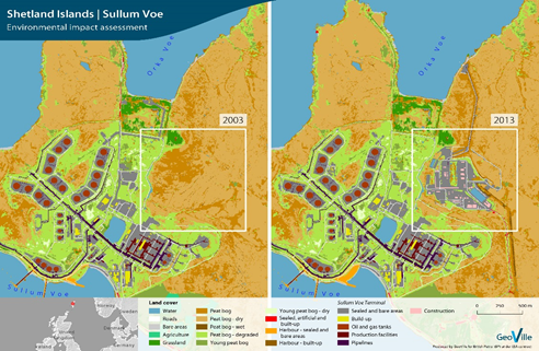
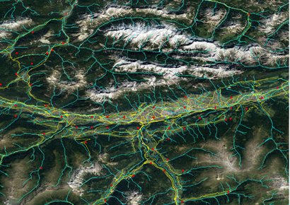
Page: Product Sheet: Hydrological Network and Surface Water Dynamics
|
|
PNG File image2020-2-19_16-55-9.png |
196 kB |
Michaela Seewald |
Feb 19, 2020 15:55 |
Feb 19, 2020 15:55 |
|
Page: Product Sheet: Ground Water Monitoring
|
|
PNG File image2020-2-19_16-54-40.png |
176 kB |
Michaela Seewald |
Feb 19, 2020 15:54 |
Feb 19, 2020 15:54 |
|
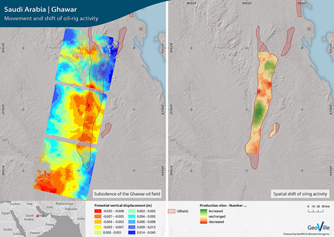
Page: Product Sheet: Geophysical Assessment
|
|
PNG File image2020-2-19_16-54-6.png |
170 kB |
Michaela Seewald |
Feb 19, 2020 15:54 |
Feb 19, 2020 15:54 |
|
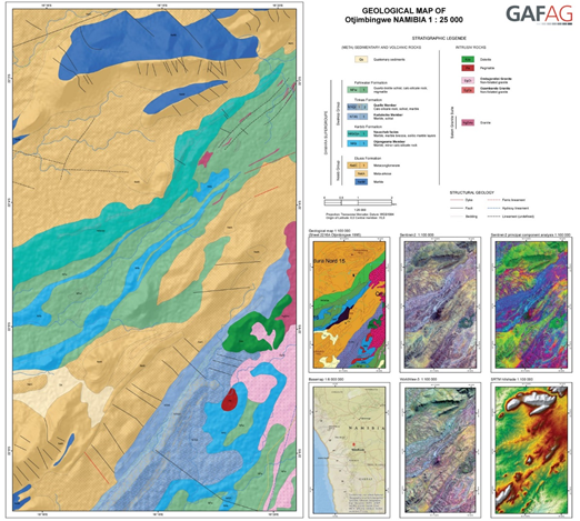
Page: Product Sheet: Geological Mapping
|
|
PNG File image2020-2-19_16-53-31.png |
751 kB |
Michaela Seewald |
Feb 19, 2020 15:53 |
Feb 19, 2020 15:53 |
|
Page: Product Sheet: Elevation
|
|
PNG File image2020-2-19_16-52-50.png |
390 kB |
Michaela Seewald |
Feb 19, 2020 15:52 |
Feb 19, 2020 15:52 |
|
Page: Product Sheet: Demonstration of Rehablitation/Revegetation
|
|
PNG File image2020-2-19_16-52-16.png |
523 kB |
Michaela Seewald |
Feb 19, 2020 15:52 |
Feb 19, 2020 15:52 |
|
Page: Product Sheet: Cultural Heritage
|