Elevation | ||||||||
SRTM elevation mapping (Source: NASA/JPL-Caltech/NGA) | ||||||||
PRODUCT DESCRIPTION | ||||||||
Category | ||||||||
|
| |||||||
Uses | ||||||||
| ||||||||
Challenges addressed | ||||||||
| ||||||||
Geo-information needs | ||||||||
| ||||||||
Description | ||||||||
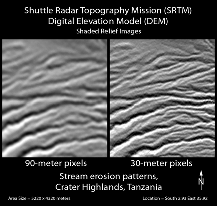
Elevation mapping is predominantly represented by a Digital Elevation Model (DEM). The terms DEM, Digital Surface Model (DSM) and Digital Terrain Model (DTM) are often used interchangeably, the DSM will take into account the surface features (such as buildings or trees) and DTM will focus on bare earth. Most data providers use the term DEM as the generic term to describe DSM and DTM, as such DEM will be used for this product sheet. Elevation maps are useful at a variety of scales from regional to basin to project area, depending on the requirements the user can select the best suited resolution to address the challenge. While DEM with a resolution ≥ 30 m are freely available, resolutions better than 30 m these are normally commercial datasets. See input data sources for more details. From EO sources there are two main ways of creating a DEM.
| ||||||||
Known restrictions / limitations | ||||||||
| ||||||||
Lifecycle stage and demand | ||||||||
Exploration | Environmental Assessment and Permitting | Design, Construction and Operations | Mine Closure and Aftercare | |||||
| ■■■■ | ■■■ | ■ | ■ | |||||
All lifecycle stages: Can be used at all stages with the cycle. Elevation mapping is useful for the raw materials industry some examples below. Exploration: Topography is very important with respect to geology. Ore deposition within specific geographies will be associated with specific rock types and certain rock types are known to develop certain topographic features as surface expressions of much deeper features, which may be indicative of the presence of mineral. Topography of an area, when combined with other remote sensing data can be used to produce more detailed geological maps which can be used in mineral exploration. Environmental Assessment & Permitting: A topographical map (typically 1 in 50,000 OS map) will be typically required to be submitted as part of a planning permit application, with the area of the proposed operation highlighted on the map this will describe the regional setting of the proposed operation. More detailed topographical assessment will also need to take place on a tighter area to better understand how the operation will sit in the environment and what visual impact will there be from the various infrastructural elements. Design, Construction & Operations: Topography can support the site design and layout of infrastructure, stockpiles and waste management Mine Closure & Aftercare: Topography can support by demonstration of site back to baseline. | ||||||||
Geographic coverage | ||||||||
| Global coverage (with a few restrictions, see above) | ||||||||
EARSC Thematic Domain | ||||||||
Domain | Land | |||||||
| Sub-domain | Topography | |||||||
| Product description | Baseline mapping | |||||||
PRODUCT SPECIFICATIONS | ||||||||
Input data sources | ||||||||
| ||||||||
Spatial resolution and coverage | ||||||||
| Resolution | Sensor(s) | |||||||
| 1-4 m | Elevation 1 & 4 (Pleiades DEM 1m & 4 m) | |||||||
| 8 m | Elevation 7 (SPOT DEM 8 m) | |||||||
| 12-90 m | WorldDEM (TanDEM-X, DSM and DTM | |||||||
| 30 m | ASTER | |||||||
| 90 m | SRTM version 3 (90 m) | |||||||
| 1 km | GTOPO 30 | |||||||
Minimum Mapping Unit (MMU) | ||||||||
n/a (the product is directly based on the input data; the smallest unit is 1 pixel, see above for spatial resolution of pixel size ranging from 1 m to 1 km) | ||||||||
Accuracy / constraints | ||||||||
Spatial accuracy: For horizontal accuracy the goal would be one pixel, but depends on reference data Accuracies for a few off-the-shelf elevation products:
| ||||||||
Accuracy assessment approach & quality control measures | ||||||||
Field survey spread over 16 locations of a 25 km2 area DEM, using DGPS or RTK surveying and processing the results | ||||||||
Frequency / timeliness | ||||||||
Frequency: The frequency is constrained by satellite revisit and acquisition, but also processing requirements. Depending on the requirements of the customer the best suitable satellite sensor has to be chosen regarding spatial / spectral resolution as well as revisit frequency and timeliness. For coarser resolution DEMs, static products exist for most parts of the globe. Timeliness of deliverable: Stereo acquisitions for precision DEMs (VHR1 data for example) often need to be tasked. There are certain criteria which need to be fulfilled for this tasking i.e. the time between acquisitions, the cloud cover, the angle of the image required. To get the required accuracy ground control points are needed. The timeframe for archived data is about 3 weeks, for tasking it can go up to months. Off-the-shelf products can be delivered within a few days. | ||||||||
Availability | ||||||||
1 km (GTOPO30), 90 m (SRTM version 3) and 30 m (Aster GDEM2) DEM are freely available. For higher resolution this data needs to be commercially acquired. These data sets for example are Elevation 30 (SPOT DEM 30 m), WorldDEM (TanDEM-X 12 m). For higher resolutions (e.g. Elevation 8 (SPOT DEM 8 m), Elevation 4 & 1 (Pleiades DEM 4 m & 1 m), WorldView Elevation Suite (4 m & 1 m)) processing will have to take place, whether there are suitable images in archive or if they need to be tasked. Working to time frames that fit in with GCP collect is important as well. | ||||||||
Delivery / output format | ||||||||
Data type: Raster formats (depending on customer needs) File format: Geotiff (standard - any other OGC standard file formats) | ||||||||
USE CASE | ||||||||
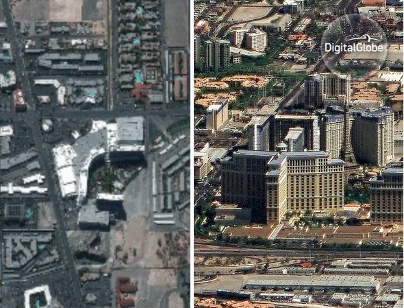
High resolution stereo photo elevation mapping using WorldView 4 (Source: DigitalGlobe) Using the high-resolution elevation data of WorldView 4 it is possible to perform stereo photo eleation mapping. The satellite also has an in-built control moment gyros, which allows to capture imagery in two angles as can be seen in the picture above. | ||||||||
This page has no comments.