Cultural Heritage | ||||||||
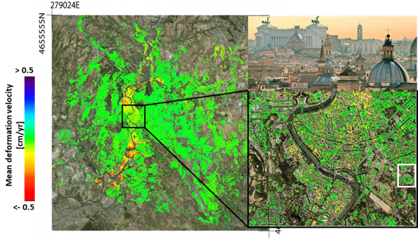
Surface elevation changes derived from Interferometric Synthetic Aperture Radar (InSAR) in Rome (Source: IREA-CNR, Italy) | ||||||||
PRODUCT DESCRIPTION | ||||||||
Category | ||||||||
|
| |||||||
Uses | ||||||||
| Closure and Aftercare - The mine operator must demonstrate at closure that no impact has been caused to cultural heritage sites by the mine’s operations | ||||||||
Challenges addressed | ||||||||
| Closure and Aftercare – Affected Stakeholders | ||||||||
Geo-information needs | ||||||||
| CA-5 Demonstration no impact on national cultural heritage | ||||||||
Description | ||||||||
Around the world, UNESCO has designated 1,052 locations as World Heritage Sites worth preserving – but many of them are in danger. Nowadays, usage of earth observation is an excellent monitoring tool to protect natural and cultural heritage. The recently launched satellites open the opportunity to use very high resolution optical data together with a wider offer of spectral bands. Also the development of InSAR techniques enables earth observation to detect ground movements, which are useful for monitoring of cultural heritage. UNESCO and ESA expressed in 2013 the need for monitoring these sites using Earth Observations (EO) through the “Open Initiative on the Use of Space Technologies to Monitor UNESCO Sites. Since then several initiatives have been set up including a collaboration between ESA and the UNESCO to monitor gorilla habitats in eastern and central Africa using space technologies and the collaboration between DLR and Airbus to use TerraSAR-X data for monitoring of UNESCO world heritage sites and archeological site detection using multispectral analysis of vegetation/soil conditions. Other initiatives include SpaceToPlace, which empowers UNESCO site managers and planning authorities to incorporate Sentinel data from the European Copernicus programme into their daily work routines. Its online and easy-to-use training environment features remote-sensing software alongside dedicated learning modules. Practical hands-on exercises impart the necessary k The data and information offered by the Copernicus programme can contribute to tangible and natural cultural heritage preservation and management. Earth Observation (EO) data is becoming increasingly instrumental, with numerous projects and applications aimed at providing products tailored to the needs of cultural heritage. Using the locations of the cultural heritage sites for mining could include developing an overview of the sites nearest to the mine pit or located within a radius to the mine pit, based on the regulations. | ||||||||
Known restrictions / limitations | ||||||||
| Cultural heritage sites can be detected when they fit within the available spatial resolutions of existing products. Also, depending on the application different limitations occur (cloud cover, spatial/temporal resolution). | ||||||||
Lifecycle stage and demand | ||||||||
Exploration | Environmental Assessment and Permitting | Design, Construction and Operations | Mine Closure and Aftercare | |||||
| ■ | ■■ | ■ | ■■ | |||||
General: The mine operator must demonstrate that no impact has been caused to cultural heritage sites by the mine’s operations Environmental Assessment & Permitting: The mine operator must demonstrate that no impact has been caused to cultural heritage sites by the mine’s operations and the situation returns back to base line conditions. Mine Closure & Aftercare: All Special Area of Conservation (SAC) sites will have been identified during the permitting process. The mine operator must demonstrate at closure that no impact has been caused to these sites by the mine’s operations. The area will be dependent on the scale of the operation. The impact can extend beyond the mine’s boundary. An area of more than 100km2 may need to be assessed, depending on the operation. In additional SAC's within 15km of the boundary of the site need to be specifically assessed with a resolution of 1 to 10m2 depending on the species. This is a once off exercise to be completed at the end of mine closure. Authorities may require follow up surveys during the aftercare period, this would be site specific and not expected to be more frequent than annual | ||||||||
Geographic coverage | ||||||||
| Coverage is global | ||||||||
EARSC Thematic Domain | ||||||||
Domain | Land | |||||||
| Sub-domain | Land use | |||||||
| Product description | Monitor land cover and detect change | |||||||
PRODUCT SPECIFICATIONS | ||||||||
Input data sources | ||||||||
| Satellite | TerraSAR-X | SPOT 6/7 | Sentinel | |||||
| Status | Operational | Operational | Operational | |||||
| Operator | DLR/Airbus | CNES/Airbus | ESA | |||||
| Data availability | Commercial | Commercial | Public | |||||
| Resolution (m) | 1, 3, 16 m | 1.5 m (panchromatic) 6 m (multispectral) | Depending on spectral band (10-60 m) | |||||
| Coverage | Global | Global | Global | |||||
| Frequency (days) | 2.5-11 days | Twice daily | 5 days | |||||
| Launch year | 2007 | 2012 | 2015 | |||||
Website | link | link | link | |||||
Minimum Mapping Unit (MMU) | ||||||||
Based on the input data; down to a pixel. | ||||||||
Accuracy / constraints | ||||||||
Thematic accuracy: n/a Spatial accuracy: see table above | ||||||||
Accuracy assessment approach & quality control measures | ||||||||
This is done by field validation using in-situ measurements. | ||||||||
Frequency / timeliness | ||||||||
Observation frequency: Timeliness of deliverable: | ||||||||
Availability | ||||||||
| Data is typically freely available for non-commercial use through the open data policy of the different space agencies. See for an overview of the used satellites the table above. | ||||||||
Delivery / output format | ||||||||
Typically, the datasets are delivered in HDF5, NetCDF, binary or in shapefiles. | ||||||||
USE CASE | ||||||||
Surface elevation changes derived from Interferometric Synthetic Aperture Radar (InSAR) in Rome (Source: IREA-CNR, Italy) InSAR has been used to detect changes in the Vatican in Rome. This way can be monitored whether movement of buildings is stable, or changes have occurred after time. For mining this can be useful, to see whether monuments or locations of cultural heritage remain stable/move at existing speed during and after construction. | ||||||||

This page has no comments.