Soil Moisture | ||||||||
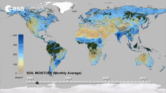
Over 30 years observations based on the ESA soil moisture CCI (Source: ESA). | ||||||||
PRODUCT DESCRIPTION | ||||||||
Category | ||||||||
|
| |||||||
Uses | ||||||||
| ||||||||
Challenges addressed | ||||||||
| ||||||||
Geo-information needs | ||||||||
| ||||||||
Description | ||||||||
Soil moisture is crucial for all biological life on land and influences the energy, water and carbon fluxes at the land surface. Further, it influences hydrological and agricultural processes, runoff generation, drought development and impacts on the climate system. Thus, soil moisture is a crucial parameter for a large number of applications including flood prediction and identification of wet areas. Soil moisture can be derived using satellite observations and a retrieval algorithm, which often solves both the variables of soil moisture and vegetation. Typical sensors that observe soil moisture are passive microwave (SMOS, AMSR-E, SMAP) and SAR (ASCAT, SMAP, Sentinel). The satellite-based product expresses the soil moisture in volumetric content of moisture in the top 5 cm of the soil. ESA’s soil moisture CCI initiative (2011-2018) supported the merging of active and passive remotely sensed soil moisture and performing comparison analyses. Other moisture parameter are the Surface Soil Moisture (SSM) and the Soil Water Index (SWI). Both are based on a fusion of Sentinel 1 and ASCAT soil moisture within the Copernicus Global Land Service. The SSM represents the degree of saturation of the topmost soil layer (< 5 cm) and is given in percent, ranging from 0% (dry) to 100% (wet). The SWI represents the soil moisture content in the first 1 meter of the soil in relative units ranging between wilting level (0) to field capacity (100). The algorithm uses an infiltration model describing the relation between surface soil moisture and profile soil moisture as a function of time. | ||||||||
Known restrictions / limitations | ||||||||
| ||||||||
Lifecycle stage and demand | ||||||||
Exploration | Environmental Assessment and Permitting | Design, Construction and Operations | Mine Closure and Aftercare | |||||
| ■■ | ■■■ | ||||||
Design, Construction & Operations: Discharging water into the environment is an activity that many mines around the world must undertake (as mining activities will in many cases end up below the water table). Mines are required to assess the impact that their water discharge may have on the receiving environment by measuring the volume of water and mass emission of various chemical parameters. They must also assess the assimilative capacity of the receiving environment for the volume of water and the chemical parameters, this is achieved by measuring the receiving water conditions. Mapping the key locations with respect to water discharge and receipt into the environment is important to allow this information to be presented geographically. Besides surface water changes, soil moisture changes can also be a parameter, mostly to assess liquefaction processes. In addition, moisture content of covers for waste rock dumps, stockpiles and tailings will influence their performance, and thus monitoring is desirable. Mine Closure & Aftercare: When a mine is in the closure or aftercare period it is the time when discrete plumes can be most problematic, particularly when operators have failed to implement a good closure programme or when unforeseen extreme precipitation events occur. Mapping the location and progress of any plumes and presenting these data geographically is an important aspect with respect to this parameter. Soil moisture could be an indirect parameter added to surface water changes. | ||||||||
Geographic coverage | ||||||||
| Coverage is global | ||||||||
EARSC Thematic Domain | ||||||||
Domain | Land | |||||||
| Sub-domain | Inland water | |||||||
| Product description | Assess ground water and run-off | |||||||
PRODUCT SPECIFICATIONS | ||||||||
Input data sources | ||||||||
| Satellite | SMOS | AMSR-E | SMAP | MetOp-ASCAT | Soil Water Index (SWI) Combination Sentinel1/ASCAT | |||
| Status | In operation | Not operational | In operation | In operation | In operation | |||
| Operator | ESA | NASA | NASA | EUMETSAT | Copernicus | |||
| Data availability | Public | Public | Public | Public | Public | |||
| Resolution (m) | 35-50 km | 25 km | 3-9 km | 12.5 km | 1 km Europe, 0.1 degree Global | |||
| Coverage | Global | Global | Global | Global | Global | |||
| Frequency (days) | 1-3 days | 1 day | 2-3 days | 6-36 hours | 1 day | |||
| Launch year | 2009 | 2002-2011 | 2015 | 2007 | 2015 | |||
Website | link | link | link | link | link | |||
Higher resolution soil moisture data is available in commercial companies. ESA’s Soil Moisture CCI merges active and passively acquired soil moisture product. https://www.esa-soilmoisture-cci.org/ There have been several initiatives to retrieve soil moisture on Sentinel 1. These will be published by the specific developers. | ||||||||
Minimum Mapping Unit (MMU) | ||||||||
n/a (the product is directly based on the input data; the smallest unit is 1 pixel, see above for spatial resolution of pixel size). | ||||||||
Accuracy / constraints | ||||||||
Thematic accuracy: Inland Water – Assess Groundwater and Runoff. 50% Soil moisture gives information about the water in the top 5 cm of the soil and indirectly says something about the groundwater levels Spatial accuracy: See above. For seepage detection a higher resolution is needed than currently provided. | ||||||||
Accuracy assessment approach & quality control measures | ||||||||
Soil moisture retrieval algorithms are usually calibrated by making use of field experiments with in situ and airborne vehicles. Furthermore, in science the soil moisture product have been evaluated and compared against each other. | ||||||||
Frequency / timeliness | ||||||||
Usually within 24 hours after acquisition. | ||||||||
Availability | ||||||||
Data is typically freely available for non-commercial use through the open data policy of the different space agencies. See for an overview of the used satellites the table above. | ||||||||
Delivery / output format | ||||||||
Typically, the datasets are delivered in raster NetCDF format, HDF5 or TIFF. | ||||||||
USE CASE | ||||||||
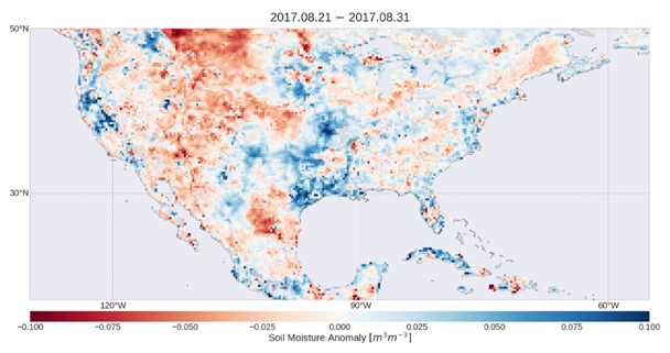
Source: Anomalies of soil moisture over the gulf of New Mexico (Source: Soil Moisture CCI/ESA). The image shows soil moisture anomalies in the United States and the Gulf of Mexico for the last 10 days of August 2017. Blue depicts areas with higher soil moisture than usual, while brown shows lower soil moisture than usual for this time of the year. The image clearly shows the impact of Hurricane Harvey in southern Texas. Based on 30 year long soil moisture measurements, as developed within the Soil Moisture CCI, a better understanding of the water cycle and climate is possible, as well as monitoring of agriculture and managing our water resources. | ||||||||
This page has no comments.