Soil structure and chemistry | ||||||||
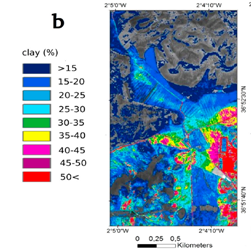
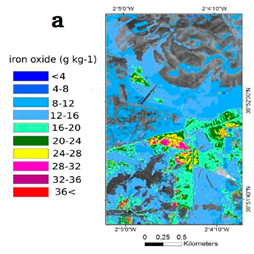
Iron oxide (a) and clay prediction (b) from airborne imagery in Cabo de Gata, Spain (Steinberg et al. 2016) | ||||||||
PRODUCT DESCRIPTION | ||||||||
Category | ||||||||
|
| |||||||
Uses | ||||||||
Exploration
Environmental Assessment & Permitting
Design, Construction & Operations
Mine Closure and Aftercare
| ||||||||
Challenges addressed | ||||||||
| ||||||||
Geo-information needs | ||||||||
E-3: Geochemical mapping P-7: Soil/Sediment chemistry DO-21: Monitoring of any pollution plumes CA-1: Demonstration of rehabilitation/revegetation; CA-2: Characterisation of flora and fauna; CA-6: Demonstrate no impact on a specific area of conservation; CA-9: Demonstration of return to baseline water quality; CA-10: Plume tracing of leaks or seepage | ||||||||
Description | ||||||||
Remote sensing observations and multispectral imaging offer the possibility to perform a continuous mapping and monitoring of soil conditions over large areas at a low-cost (compared to ground field analysis). The reflectance and absorption of the light at the surface at different wavelengths coupled with the development of empirical models allows for the characterisation of soil properties and chemistry remotely (e.g., Steinberg et al., 2016). Multispectral imaging is widely used in studying the minerals’ spectral signatures of other planetary bodies such as on the lunar and Martian surfaces (e.g., Bandfield 2002; Lucey et al. 2004). On earth several limitations still exist, such as the abundance of volatiles (such as water), vegetation cover and complex geological evolution resulting in rather complex spectral signatures (see known restrictions/limits). So far, soil properties such as iron oxide, clay, soil organic carbon have already been successfully determined from satellite- and airborne-based type of data at several locations on Earth such as in Spain (Steinberg et al., 2016) and Brazil (Pinheiro et al., 2017). The coupling of multispectral imaging with ground data is a powerful tool which will help throughout all the stages of the mining life cycle (exploration, environmental assessment, operations and aftercare). | ||||||||
Known restrictions / limitations | ||||||||
The area to be assessed in soil structure and chemistry is rather difficult to estimate. Near the mining site, the resolution to be assessed will be dependent on the type and scale of the operation. The resolution may range from one sample per hectare to a tight sampling grid of 10 m2 where 'hot spots' or variations in concentration due to specific mining activities are expected. These sources of contamination can be carried out over extensive areas (hundreds of km2) through water and air emissions. Thus, a combination of ground surface, geological and remote sensing analysis is advised. Soil is often a complex mixture of components, resulting in poorly defined spectra (Steinberg et al., 2016). Spectroscopy imaging for soil mapping and survey tend to perform better with soil containing chromophores (part of the molecule responsible for its colour), with soil exposed at the surface and homogeneously distributed and when local ground data are available (Steinberg et al., 2016). Such requirements are vital in order to develop an empirical, reliable model in order to relate the spectral data with soil parameters and chemistry. | ||||||||
Lifecycle stage and demand | ||||||||
Exploration | Environmental Assessment and Permitting | Design, Construction and Operations | Mine Closure and Aftercare | |||||
| ■■■ | ■■■■ | ■■■ | ■■■■ | |||||
Geographic coverage | ||||||||
| Demand and coverage are global. | ||||||||
EARSC Thematic Domain | ||||||||
Domain | Land | |||||||
| Sub-domain | Land Ecosystems | |||||||
| Product description | Monitor land pollution | |||||||
PRODUCT SPECIFICATIONS | ||||||||
Input data sources | ||||||||
| Satellite | Sentinel-2 | Landsat-8 | Worldview-1, 2 and 3 | EnMap | HISUI | SHALOM | ||
| Status | In operation | In operation | In operation | Planned | Planned | Planned | ||
| Operator | ESA | NASA | Digital Globe | DLR | Japanese Space Agency | Italian and Israeli Space Agency | ||
| Data availability | Public | Public | Commercial, on demand | TBD, likely public but on demand | TBD, likely public but on demand | TBD, likely public but on demand | ||
| Resolution (m) | 10 - 60 | 15 - 100 | 0.31 - 0.46 | 30 | 20 - 30 | < 10 | ||
| Coverage | Global | Global | Global | Global | Global | Global | ||
| Frequency (days) | 5 | 16 | < 2 | 4 | 4 | < 4 | ||
| Launch year | 2015 | 2013 | 2007/2009/2014 | 2020 | 2019 | 2020 | ||
Website | link | link | link | link | link | link | ||
NOTE: Airborne and drone imagery products (optical and infrared) for local and regional analysis might also be used in order to obtain higher image resolution. NOTE 2: Most of the satellite operator provide images under raster type of formats such as “.tif” files. Satellite products are often gathered into a single product containing several bands (i.e., images obtained at different wavelengths). | ||||||||
Minimum Mapping Unit (MMU) | ||||||||
Minimum detectable feature size (dependent on the input pixel resolution, ~5 - 10 px) | ||||||||
Accuracy / constraints | ||||||||
Thematic accuracy: >85% threshold for overall accuracy / class accuracy. Spatial accuracy: Dependent on the input pixel resolution; typically, ~0.5 - 1 pixel. | ||||||||
Accuracy assessment approach & quality control measures | ||||||||
Dependent on the input pixel resolution; typically, ~0.5 - 1 pixel. | ||||||||
Frequency / timeliness | ||||||||
The development of an empirical model to relate the multispectral imagery with soil and sediment chemistry and physical composition is the most time-demanding step and likely to be completed within months of work (ground sample analysis collection and laboratory measurements). Such kind of data can be obtained by conducting additional processing steps from the original satellite data. From this point, the digitization of soil and sediment chemistry and physical composition from remote sensing data will be able to be completed within a few hours/days of work regardless of how large the area disturbed by mining activities is. However, recalibration of the model might be needed over the lifetime of a mine, to account for small changes in soil chemistry that might not be directly detectable from the mineral composition measured by the satellite. Authorities may require yearly surveys during the construction, operation and aftercare periods and thus soil structure and chemistry can be investigated throughout time (from baseline to agreed endpoint). | ||||||||
Availability | ||||||||
Data from Sentinel and satellites are freely available through the open data policy of the European Space Agency. Data is made available typically within 6-12 hours of satellite fly-over (similar for Landsat through NASA open data policy). Worldview data is commercially licensed and must be purchased through operator/vendor. Usually available within hour(s) of satellite fly-over. Airborne imagery products can be purchased through operator/vendor. Usually available within hours or days after acquisition. | ||||||||
Delivery / output format | ||||||||
Mineralogy product Map of minerals in the region of interest Output: raster formats - GeoTiff, reports of specified and/or requested key indicators, client-specified spatial formats Soil and sediment chemistry product Map of soil and sediment chemistry in the region of interest (and their evolution in time during the operational phase) Output: raster formats - GeoTiff, reports of specified and/or requested key indicators, client-specified spatial formats | ||||||||
USE CASE | ||||||||
Cabo de Gata, Spain – Soil chemistry monitoring The aim of the study conducted by Steinberg et al. (2016) was to predict common surface soil properties based on visible and infrared airborne imagery products for the Cabo de Gata region in Spain. Such method could be used in mining applications to for example monitor the changes of surface soil properties and investigate whether mining activities affect the nearby soil chemistry. | ||||||||

This page has no comments.