Geophysical Assessment | ||||||||
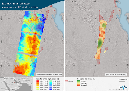
Movement and shift of oil-rig activity (Source: GeoVille) | ||||||||
PRODUCT DESCRIPTION | ||||||||
Category | ||||||||
|
| |||||||
Uses | ||||||||
| ||||||||
Challenges addressed | ||||||||
| ||||||||
Geo-information needs | ||||||||
| ||||||||
Description | ||||||||
An area, where mining takes place, must be structurally competent and must not be susceptible to subsidence or collapse. Therefore, an assessment is needed before any construction takes place. Also, further monitoring during mining activities is of high need, especially to monitor structural stability of buildings. This product addresses these issues by monitoring the mining area and detecting any changes within the relief. Change detection is usually performed by using radar satellite imagery (Synthetic Aperture Radar, SAR) for analysis. To monitor any changes, images from different points in time are compared to analyse and highlight severe deformations. The detected variations in reflectivity indicate morphological changes, soil moisture variations, vegetation growth and anthropogenic causes. To assess surface movements, processing radar imagery with interferometric techniques can furthermore be utilized in this matter. With this information it is also possible to conclude on possible damages in infrastructure. Information on movements, variations and changes can be delivered in various formats, such as vector and raster formats, as well as reports. Maps can show the status quo and highlight problematic changes. | ||||||||
Known restrictions / limitations | ||||||||
| Accuracy and timeliness are dependent on the resolution and repeat time of the satellite. Concerning change products consistent data from the same sources and the same period for the entire region is needed. | ||||||||
Lifecycle stage and demand | ||||||||
Exploration | Environmental Assessment and Permitting | Design, Construction and Operations | Mine Closure and Aftercare | |||||
| ■■■■■ |
| ■■■■■ | ■■ | |||||
Exploration:
Design, Construction & Operations:
Mine Closure & Aftercare:
| ||||||||
Geographic coverage | ||||||||
| Globally available. | ||||||||
EARSC Thematic Domain | ||||||||
Domain | LAND | |||||||
| Sub-domain | Geology | |||||||
| Product description | Map geological features | |||||||
PRODUCT SPECIFICATIONS | ||||||||
Input data sources | ||||||||
| Satellite | Sentinel 1 | TerraSAR-X | COSMO-SkyMed | |||||
| Status | In operation | In operation | In operation | |||||
| Operator | ESA | DLR/Astrium | e-Geos | |||||
| Data availability | Public | Commercial, on demand | Commercial, on demand | |||||
| Resolution (m) | 5 - 100 | 1 - 16 | 1 - 3 | |||||
| Coverage | Global | Global | Global | |||||
| Frequency (days) | < 3 | < 5 | 4 - 16 | |||||
| Launch year | 2014 | 2007 | 2007 | |||||
Website | link | link | link | |||||
Minimum Mapping Unit (MMU) | ||||||||
Variable, depending on source data resolution. A MMU as small as 1 m is possible. | ||||||||
Accuracy / constraints | ||||||||
Thematic accuracy: Analysis shows movements, variations and changes of the surface. Spatial accuracy: Dependent on input pixel resolution. | ||||||||
Accuracy assessment approach & quality control measures | ||||||||
N/A | ||||||||
Frequency / timeliness | ||||||||
Observation frequency: Every one or more days, depending on satellite. Timeliness of delivery: Within five (working) days of sensing. | ||||||||
Availability | ||||||||
Data from all Sentinel satellites are freely available through the open data policy of the operator ESA (Sentinel-1A since 2014, Sentinel-1B since 2016). TerraSAR-X satellite imagery is commercially available through EADS Astrium GmbH, COSMO-SkyMed must be purchased from e-Geos. | ||||||||
Delivery / output format | ||||||||
Data type: Raster formats File format: GeoTIFF Other delivery format: Report | ||||||||
USE CASE | ||||||||
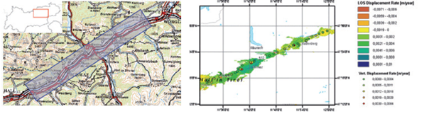
(Copyright: Österreichische Bundesbahnen, ESA, GeoVille This example shows spatial monitoring of surface movements along a transport axes in Tyrol. SAR data was used here. Displacements in the centimeter range could be detected. Comparing imagery before and after mining commences makes it possible to detect changes very small changes and at an early stage. Combined with other products such as the settlement map, affected areas and buildings might be detected easily. | ||||||||
This page has no comments.