| Name
|
Size
|
Creator |
Creation Date
|
Last Modification Date
|
Labels |
Attached To |
|
PDF File EO4RM_Land_PitSlopeStability.pdf |
180 kB |
Michaela Seewald |
May 07, 2020 07:40 |
May 07, 2020 07:40 |
|
Page: Product Sheet: Tailings Dam Monitoring
|
|
PDF File EO4RM_Land_StockpileMeasurement_v1.pdf |
179 kB |
Michaela Seewald |
May 08, 2020 09:02 |
May 08, 2020 09:02 |
|
Page: Product Sheet: Stockpile Measurement
|
|
PNG File image2020-2-19_11-54-45.png |
178 kB |
Michaela Seewald |
Feb 19, 2020 10:54 |
Feb 19, 2020 10:54 |
|
Page: Product Sheet: Surface Subsidence
|
|
PNG File image2020-2-19_11-54-45.png |
178 kB |
Michaela Seewald |
May 07, 2020 07:19 |
May 07, 2020 07:19 |
|
Page: Product Sheet: Pit Slope Stability
|
|
PNG File image2020-2-19_11-54-45.png |
178 kB |
Michaela Seewald |
May 07, 2020 07:40 |
May 07, 2020 07:40 |
|
Page: Product Sheet: Tailings Dam Monitoring
|
|
PNG File image2020-2-19_16-44-30.png |
176 kB |
Michaela Seewald |
Feb 19, 2020 15:44 |
Feb 19, 2020 15:44 |
|
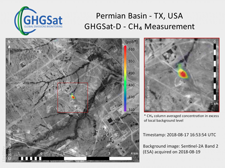
Page: Product Sheet: Air Quality CH4
|
|
PNG File image2020-2-19_16-54-40.png |
176 kB |
Michaela Seewald |
Feb 19, 2020 15:54 |
Feb 19, 2020 15:54 |
|
Page: Product Sheet: Geophysical Assessment
|
|
PNG File image2020-2-19_16-54-6.png |
170 kB |
Michaela Seewald |
Feb 19, 2020 15:54 |
Feb 19, 2020 15:54 |
|
Page: Product Sheet: Geological Mapping
|
|
PNG File image2020-2-19_14-3-28.png |
157 kB |
Michaela Seewald |
Feb 19, 2020 13:03 |
Feb 19, 2020 13:03 |
|
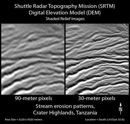
Page: Product Sheet: Elevation
|
|
PNG File image2020-2-19_14-34-28.png |
149 kB |
Michaela Seewald |
Feb 19, 2020 13:34 |
Feb 19, 2020 13:34 |
|
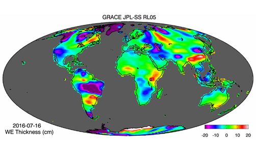
Page: Product Sheet: Ground Water Monitoring
|
|
PNG File image2020-2-19_11-22-25.png |
125 kB |
Michaela Seewald |
Feb 19, 2020 10:22 |
Feb 19, 2020 10:22 |
|
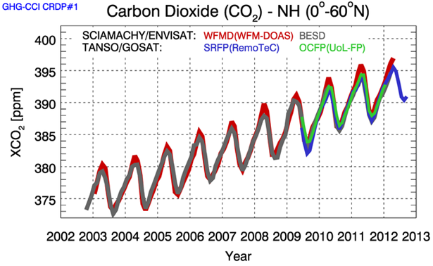
Page: Product Sheet: Air Quality CO2
|
|
PNG File image2020-2-19_17-3-30.png |
120 kB |
Michaela Seewald |
Feb 19, 2020 16:03 |
Feb 19, 2020 16:03 |
|
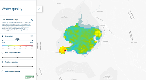
Page: Product Sheet: Water Quality
|
|
PNG File image2020-2-19_15-21-58.png |
112 kB |
Michaela Seewald |
Feb 19, 2020 14:21 |
Feb 19, 2020 14:21 |
|
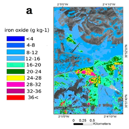
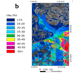
Page: Product Sheet: Soil structure and chemistry
|
|
PNG File image2020-2-19_17-1-18.png |
112 kB |
Michaela Seewald |
Feb 19, 2020 16:01 |
Feb 19, 2020 16:01 |
|
Page: Product Sheet: Soil structure and chemistry
|
|
PNG File image2020-2-19_15-22-0.png |
100 kB |
Michaela Seewald |
Feb 19, 2020 14:22 |
Feb 19, 2020 14:22 |
|
Page: Product Sheet: Soil structure and chemistry
|
|
PNG File image2020-2-19_16-55-37.png |
90 kB |
Michaela Seewald |
Feb 19, 2020 15:55 |
Feb 19, 2020 15:55 |
|
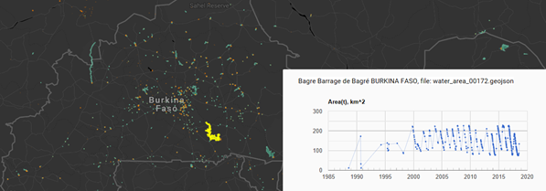
Page: Product Sheet: Hydrological Network and Surface Water Dynamics
|
|
PNG File image2020-2-19_14-42-53.png |
84 kB |
Michaela Seewald |
Feb 19, 2020 13:42 |
Feb 19, 2020 13:42 |
|
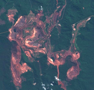
Page: Product Sheet: Land disturbed by mining acitivites
|
|
PNG File image2020-2-19_14-47-48.png |
84 kB |
Michaela Seewald |
Feb 19, 2020 13:52 |
Feb 19, 2020 13:52 |
|
Page: Product Sheet: Land Use Mapping
|
|
PNG File image2020-2-19_14-47-48.png |
84 kB |
Michaela Seewald |
Feb 19, 2020 13:47 |
Feb 19, 2020 13:47 |
|
Page: Product Sheet: Land progressively rehabilitated
|
|
PNG File image2020-2-19_14-42-51.png |
83 kB |
Michaela Seewald |
Feb 19, 2020 13:42 |
Feb 19, 2020 13:42 |
|
Page: Product Sheet: Land disturbed by mining acitivites
|