Air Quality CH4 | ||||||||
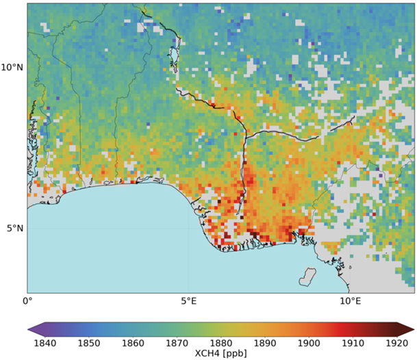
Methane concentrations over wetlands in Nigeria based on Sentinel 5-p data, processed by SRON (Source: ESA) | ||||||||
PRODUCT DESCRIPTION | ||||||||
Category | ||||||||
|
| |||||||
Uses | ||||||||
| ||||||||
Challenges addressed | ||||||||
| ||||||||
Geo-information needs | ||||||||
| ||||||||
Description | ||||||||
Atmospheric methane (CH4) is the second-most abundant anthropogenic greenhouse gas (GHG) after CO2. During shale gas field development, unexpected emissions of methane and other light gases can occur. Knowledge of background and industrial emissions helps to meet emissions guidelines. Satellite EO-based quantification of methane in the troposphere is a relatively new area of research (operational methods use airborne hyperspectral systems, such as: MAMAP, AVIRIS-ng, HyTES, and CARVE). Several EO sensors have been tested. The SCIAMACHY instrument on board the ENVISAT satellite acquired CH4 monitoring data for seven years, and was a ground-breaking technology development platform. The sensor estimated total CH4 quantity of the at-nadir atmospheric column through modelling based on direct measurements of short-wave infrared (SWIR) radiation. Overall, the research reveals limitations in methane retrievals and deviations from validation data, as well as the relatively coarse spatial resolution of the observations (individual SCIAMACHY pixels are 30 km × 60 km, while some derived models average the data to a regular 1° longitude × 1° latitude grid). The newer, operational TANSO Fourier Transform Spectrometer (FTS) sensor on board the Japanese Greenhouse Gases Observing SATellite (GOSAT) is dedicated to greenhouse gas monitoring. TANSO-FTS operates in the shortwave infrared (SWIR) and thermal infrared (TIR) regions of the electromagnetic spectrum. Shortwave infrared measurements allow for the retrieval of CH4 column concentrations with high sensitivity near the Earth’s surface. In 2015, a novel instrument has been launched aboard the GHGSat nanosatellite (operating in the shortwave infrared region). It has unprecedented spatial resolution (tens of meters) and sensitivity equal to or better than any existing or previous SWIR satellite instruments. Using a novel observational paradigm, the GHGSat instrument retrieves both total CH4 values (through depth of atmosphere columns) and local emission rates for identifiable CH4 emission sources. GHGSat also measures CO2 emissions. The Sentinel-5 precursor/TROPOMI satellite was launched in 2017 and delivers observations on a daily time step. It is called precursor because it fills the gap until Sentinel 5 on MetOp-SG-A will be launched in 2020. In 2021 a new EO system dedicated to methane monitoring will be launched. The Methane Remote LiDAR Mission (MERLIN) Integrated Path Differential Absorption (IPDA) LiDAR will measure total-column CH4 with high accuracy, and represents a new approach to atmospheric monitoring – MERLIN will be a micro-satellite launched into a polar orbit by DLR and CNES. Mission planners expect CH4 concentration measurements at better than 2% error, even under cloudy or variable illumination conditions. In contrast to existing passive remote sensors, measurements in polar regions will be possible and biases due to aerosol layers and thin ice clouds will be minimised. Further, the LiDAR instrument will allow retrieval of methane fluxes in all seasons and at night time. Methane emissions can be attributed to different sources (e.g., livestock, oil and gas, and mining) and are also dependent on land cover type, and are particularly affected by wetlands. Wetland extent and land use information can be used to improve the accuracy of methane emission maps. The methane emissions monitoring product can currently deliver archived and operational regional scale methane estimates (raster image values) along with summary statistics. Significant short-term improvements in accuracy are expected due to the scheduled launch of new sensors and the development of new operational analytical methods. | ||||||||
Known restrictions / limitations | ||||||||
EO estimates of CH4 from SCIAMACHY (satellite decommissioned in 2012) yield small differences between minimum and maximum values, complicating analysis efforts. Further, estimation error magnitude is similar to the variability in the greenhouse gas mixing ratio being measured. Spatial resolution of methane retrievals from satellite-based EO are currently relatively coarse – native resolution of sensors is around 10 km (GOSAT) to 30 km (SCIAMACHY) or more. Models may average the data to a regular 1° longitude × 1° latitude grid. and MERLIN, should provide improved retrievals. Short wave infrared (SWIR) measurements from GHGSat will be in the tens of metres. The novel LiDAR system on the MERLIN satellite will be dedicated to CH4 monitoring and will provide data with 50 km resolution. Both systems will measure CH4 abundance with an accuracy of about 1-2%. | ||||||||
Lifecycle stage and demand | ||||||||
Exploration | Environmental Assessment and Permitting | Design, Construction and Operations | Mine Closure and Aftercare | |||||
| ■ | ■■■■ | ■■ | ■■ | |||||
Environmental Assessment & Permitting: Mining companies need to understand what impact they may have on the air quality around the operation and what impact this air quality might have on people and the environment. As part of the permitting process it is necessarily to establish what the baseline is, and to demonstrate that this will not be materially affected when mining operations are underway and when the mine is closed and rehabilitated. Sampling will be required over a wide area and will typically be governed by dispersion modelling. A 10 km2 area may be taken as typical for monitoring of ambient air for a mid-size mining operation. Within this 10 km2 area in the order of 10 to 20 sampling points may be established. There are very many different parameters of interest in relation to the atmosphere. From an impact perspective; the key parameters will be Particulate and oxides of carbon, nitrogen and sulphur (COx, NOx and SOx). Individual metal parameters within the air column can also be determined. The amount of particulate that falls out on to the ground can be measured on a per m2 basis (typically 'X' mg/ m2/day). Minimum levels of detection can be taken from 'Technische Anleitung zur Reinhaltung der Luft', which is a comprehensive document issued by the German government, which describes air quality standards. This document, commonly referred to as the 'TA Luft', is used by many countries and organisations as a reference for air quality. Design, Construction &Operations: Mining operations will have point source air emissions from ventilations shafts, processing plants, labs, power plants etc. Measuring the quantity of different parameters emitted into the atmosphere (gaseous and solid) is an important aspect for mining companies to manage their potential environmental impact. Typical parameters are COx, NOx, SOx, Particulate, H2S. The area required to be assessed will be dependent on the footprint of the mining operation and could be 1 km2 to 10 km2. Air emissions can result in transboundary impacts on air quality beyond the site boundary. The extent of transboundary impact depends on the nature of the emission and also prevailing weather conditions and geographic features. Given the mobility of air emissions, an area of hundreds of km2 may need to be monitored. Air emissions will take place on a continuous basis. Many air emissions will be stable and infrequent measurement of monthly to quarterly will be sufficient. Other emissions will be more variable and subject to disruption, these would ideally be measured on a continuous basis. In addition to point source air emissions, mines will have significant fugitive air emissions, these can be plumes from pit blasts, dust form vehicular movement, dust blow off TSF / WRD, and fires. Monitoring for fugitive emissions is an important aspect for mining companies to manage their potential environmental impact. This fugitive monitoring can also be used to identify sources of emission and implement corrective actions (including identifying spontaneous combustion fires and arrange to have these extinguished). The frequency required for monitoring this parameter is site specific. In many instances monthly would be sufficient but in particular for the identification of spontaneous combustion continuous monitoring would be of benefit Mine Closure & Aftercare: Monitoring will be required during the closure and aftercare period to demonstrate that there are no ongoing air emissions from the site that could cause an impact. Point sources will no longer be operational. The focus will be on fugitive emissions from WRD's and TSF's. Assessment of this parameter will involve field work including measurement of air quality for various parameters and measurement of particulate fallout. Depending on climatic conditions air emissions can travel long distances. The area to assessed can be hundreds of km2. Monthly data is sufficient, this can be used to calculate daily deposition rates. | ||||||||
Geographic coverage | ||||||||
| Coverage is global | ||||||||
EARSC Thematic Domain | ||||||||
Domain | Atmosphere and Climate | |||||||
| Sub-domain | Atmosphere | |||||||
| Product description | Monitor Air Quality and Emissions | |||||||
PRODUCT SPECIFICATIONS | ||||||||
Input data sources | ||||||||
| Satellite | MetOp/IASI | TROPOMI/Sentinel 5-p | GHGSat | GOSAT | Merlin | |||
| Status | Operational | Operational | Operational | Operational | Future | |||
| Operator | EUMETSAT | ESA | GHGSAT | JAXA | CNES/DLR | |||
| Data availability | Public | Public | Commercial | Public | n/a | |||
| Resolution (m) | 100 km | 7x7 km | 50 m | 1 km | 50 km | |||
| Coverage | Global | Global | Target anywhere globally | Global | Global | |||
| Frequency (days) | 29 days | Daily | n/a | 3 days | 28 days | |||
| Launch year | 2006 (MetOp-A) and 2012 (MetOp-B) | 2017 | 2016 | 2009 | 2021 | |||
Website | link | link | link | link | link | |||
Minimum Mapping Unit (MMU) | ||||||||
n/a (the product is directly based on the input data; the smallest unit is 1 pixel). | ||||||||
Accuracy / constraints | ||||||||
Thematic accuracy: Atmosphere– Monitor Air Quality and Emissions. 80% For the mining industry the targeted nano-satellites probably are the most suitable source of information, because emissions from water plumes can be very low. Probably the emissions caused by mining activities won’t cross the threshold in background values of the larger satellites. Spatial accuracy: See above. Needed accuracy in the mining sector is often for large areas in relatively high spatial resolution. | ||||||||
Accuracy assessment approach & quality control measures | ||||||||
This is done by field validation using in-situ measurements. | ||||||||
Frequency / timeliness | ||||||||
n/a | ||||||||
Availability | ||||||||
Data is typically freely available for non-commercial use through the open data policy of the different space agencies. See for an overview of the used satellites the table above. | ||||||||
Delivery / output format | ||||||||
Typically, the datasets are delivered in HDF5, NetCDF, binary or in shapefiles. | ||||||||
USE CASE | ||||||||
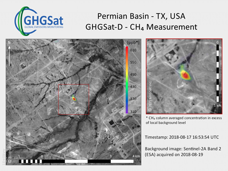
Source: GHGSat This image was taken in In August 2018, by GHGSat’s demonstration satellite Claire, over two years after her launch in June 2016. GHGSat detected emissions of methane, an important greenhouse gas, from an oil & gas facility in the Permian Basin. (Source: www.ghgsat.com) | ||||||||
This page has no comments.