| Name
|
Size
|
Creator |
Creation Date
|
Last Modification Date
|
Labels |
Attached To |
|
PNG File Surface geological mapping SStory.png |
184 kB |
Francesca Piatto |
May 10, 2022 12:02 |
May 10, 2022 12:02 |
|
Page: Valorising long-term observation data
|
|
PNG File Surface geological mapping SStory.png |
184 kB |
Francesca Piatto |
Jun 10, 2022 16:12 |
Jun 10, 2022 16:12 |
|
Page: A complete meteo-hydrological chain to support early warning systems from weather scenarios to flooded areas: the Apollo medicane use case
|
|
PNG File Surface geological mapping SStory.png |
184 kB |
Francesca Piatto |
Jul 28, 2022 09:42 |
Jul 28, 2022 09:42 |
|
Page: Flood Risk & Impact assessment through automatic change detection of S-1+S-2 images (FRIEND pilot)
|
|
PNG File Surface geological mapping SStory.png |
184 kB |
Francesca Piatto |
Jul 28, 2022 09:20 |
Jul 28, 2022 09:20 |
|
Page: How observations of sargassum west of Africa helps the Caribbean to prepare for seasonal influxes of Sargassum
|
|
PNG File Surface geological mapping SStory.png |
184 kB |
Francesca Piatto |
Jul 28, 2022 10:04 |
Jul 28, 2022 10:04 |
|
Page: Improved well-field management with Sentinel-1 SAR data
|
|
PNG File Surface geological mapping SStory.png |
184 kB |
Francesca Piatto |
Aug 12, 2022 09:46 |
Aug 12, 2022 09:46 |
|
Page: A solar nowcasting, forecasting system and atlas to guide energy management and planning in Egypt
|
|
PNG File Surface geological mapping SStory.png |
184 kB |
Francesca Piatto |
Aug 12, 2022 10:24 |
Aug 12, 2022 10:24 |
|
Page: Future climate projection of heat indices for Austrian major cities
|
|
PNG File Surface geological mapping SStory.png |
184 kB |
Francesca Piatto |
Aug 16, 2022 14:15 |
Aug 16, 2022 14:15 |
|
Page: CRITERION service
|
|
PNG File Surface geological mapping SStory.png |
184 kB |
Francesca Piatto |
Aug 17, 2022 09:48 |
Aug 17, 2022 09:48 |
|
Page: Sub-seasonal to seasonal predictions for tyre companies
|
|
PNG File Surface geological mapping SStory.png |
184 kB |
Francesca Piatto |
Mar 30, 2023 14:58 |
Mar 30, 2023 14:58 |
|
Page: Simple Water Visibility Information for Dive Planning
|
|
PNG File Surface geological mapping SStory.png |
184 kB |
Christopher Oligschläger |
Jun 10, 2020 12:43 |
Jun 10, 2020 12:43 |
|
Page: EOs adding value to historical water availability and quality information services
|
|
PNG File Surface geological mapping SStory.png |
184 kB |
Christopher Oligschläger |
Jun 10, 2020 12:43 |
Jun 10, 2020 12:43 |
|
Page: The Food Security & Sustainable Agriculture showcase; Remote sensing based crop monitoring for Early Warning - The GEOGLAM Crop Monitor Impact
|
|
PNG File Surface geological mapping SStory.png |
184 kB |
Francesca Piatto |
Mar 28, 2023 13:38 |
Mar 28, 2023 13:38 |
|
Page: Optimizing Biodiversity Conservation in the Tropical Andes: Tailoring Essential Biodiversity Variables to Policy Needs
|
|
PNG File deforestation in borneo icon.png |
183 kB |
Christopher Oligschläger |
Jun 10, 2020 12:43 |
Jun 10, 2020 12:43 |
|
Page: EO in Action
|
|
JPEG File cls-case8-fig10.jpg |
182 kB |
Christopher Oligschläger |
Jun 10, 2020 12:43 |
Jun 10, 2020 12:43 |
|
Page: Oil spill disaster in Gulf Of Mexico
|
|
PNG File using crowdsourcing for floodings.JPG.png |
182 kB |
Christopher Oligschläger |
Jun 10, 2020 12:43 |
Jun 10, 2020 12:43 |
|
Page: EO in Action
|
|
PDF File spottitt_flood monitoring.pdf |
181 kB |
Christopher Oligschläger |
Oct 15, 2021 09:37 |
Oct 15, 2021 09:37 |
|
Page: 13 – Climate Action
|
|
JPEG File Satellite based oceanography (Scisys) - Copia.jpg |
181 kB |
Christopher Oligschläger |
Jun 10, 2020 12:43 |
Jun 10, 2020 12:43 |
|
Page: Satellite based oceanography
|
|
PNG File crowd sourcing flood.png |
181 kB |
Christopher Oligschläger |
Jun 10, 2020 12:43 |
Jun 10, 2020 12:43 |
|
Page: Map and assess flooding
|
|
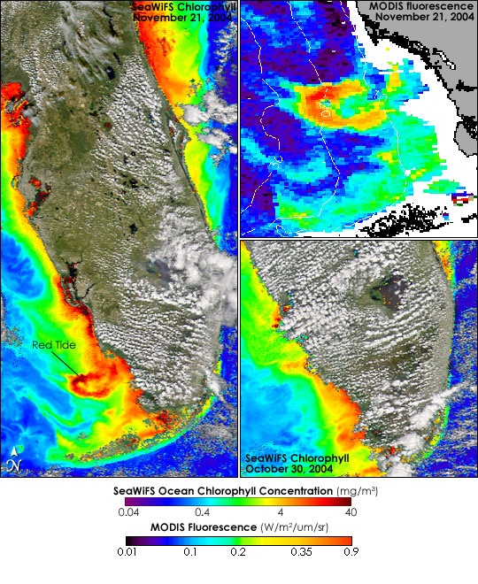
JPEG File red tide image MODIS.jpg |
181 kB |
Christopher Oligschläger |
Jun 10, 2020 12:43 |
Jun 10, 2020 12:43 |
|
Page: Harmful algal bloom monitoring
|