| Sponsor | Project | Solution provider | User |
|---|---|---|---|
|
|


Emergency
Meteo & climate
Citizen and Society
Smart Cities
The Italian Civil Protection Department carries out tasks of guidance, promotion and coordination of the entire National Service of Civil Protection. In close collaboration with Regions and Autonomous Provinces, drafts and coordinates the National Plans for risk scenarios and test their effectiveness through drills, coordinates the Service's intervention in case of emergencies of national interest, promotes activities aimed at prevision and prevention of risks, defines the general criteria for the identification of seismic zones and develops general guidelines for training activities in the field of civil protection.
The Department also coordinates the participation of the National Service to the civil protection policies of the European Union and the response to emergencies abroad.
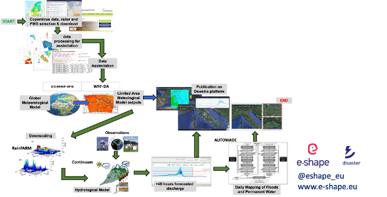
CIMA Foundation hydro-meteorological forecasting chain, including the cloud-resolving WRF model assimilating radar data and in situ weather stations (WRF-3DVAR), the fully distributed hydrological model Continuum (assimilating Sentinel 1 soil moisture data, the automatic system for water detection (AUTOWADE), using Sentinel 1 data, and the hydraulic model TELEMAC-2D, has been operated in real-time to predict the weather evolution and the corresponding hydrological and hydraulic impacts of the medicane Apollo, in support of the Italian Civil Protection Department early warning activities.
The Italian Civil Protection confirmed its interest in results like the one provided for the Apollo Medicane (24-31 October 2021). This is confirmed also by the presentation of the results at the HSAF User Workshop 2022, hosted by ZAMG and supported by EUMeTrain, where Italian Civil Protection Department (Dr. Silvia Puca) has a key role.
Having access to substantial high performance computing capabilities and storage capabilities for the execution of the complex hydro-meteorological workflow.
Cost of computing services. For sake of clarity the services is only meant for civil protection purposes and on demand, urgent computing mode.
The WRF-3DVAR model (available 330UTC, Oct. 24th, 2021) showed very good predictive capability concerning the timing and the location of most intense rainfall phenomena over Catania and Siracusa provinces in Sicily, thus enabling also very accurate discharge peaks and timing predictions for the creeks hydrological network peculiar of eastern Sicily
Based on the WRF-3DVAR model predictions, the daily run of the AUTOWADE tool, using Sentinel-1 (S1) data, was anticipated with respect to the schedule to quickly produce a flood map (S1 acquisition performed on Oct. 25th, 2021, at 5.00 UTC, flood map produced on the same day at 13.00 UTC). Moreover, considering that no S1 images of eastern Sicily were available during the period Oct. 26-30, 2021, an ad hoc tasking of the COSMO-SkyMed satellite constellation was performed, again based on the on the WRF-3DVAR predictions, to overcome the S1 data latency
The resulting automated operational mapping of floods and inland waters was integrated with the subsequent execution of the hydraulic model TELEMAC-2D
Learn more about the service: We tested the service for selected case studies, in particular Apollo medicane. The results will be available in consolidated form over the MyDewetra platform, solely for research purposes, before the final review meeting of E-SHAPE project
Learn more about e-shape: www.e-shape.eu
A question? Contact the Helpdesk: https://helpdesk.e-shape.eu
This page has no comments.