Through a co-development process and close collaboration with potential and existing users of biodiversity information in four countries situated in one of the world's most biodiverse region, the Tropical Andes, we were able to optimize biodiversity conservation by tailoring Essential Biodiversity Variables to policy needs and collaboratively preparing and publishing an EBV-based indicator that directly addresses the conservation and policy requirements of these nations.
| Sponsor | Project | Solution provider | User |
|---|---|---|---|
|
| Protected Area Managers, Scientists, Environmental Assessment Agencies in Colombia, Peru, Ecuador, and Bolivia, National Biodiversity Strategies and Action Plans. |


- Asses biodiversity
- Land ecosystem
- Monitor forests
- Monitor land use/landcover
Protected Area Managers, Scientists, Environmental Assessment Agencies in Colombia, Peru, Ecuador, and Bolivia, National Biodiversity Strategies and Action Plans.
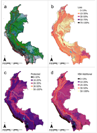
This ecosytem level indicator focuses on the Tropical Andes region of Colombia, Peru, Ecuador, and Bolivia, using both potential (pre-industrial) and recent (~2010) distribution maps of terrestrial ecosystem types. We measure long-term ecosystem loss, representation of ecosystem types within current protected areas, and quantify the additional representation offered by protecting Key Biodiversity Areas (KBAs). The mapped pixel resolution for the EBV-hypercube in the Data Portal is 270 m.

“The EBV-based indicator, published on the EBV Data Portal, is the result of extensive collaboration with national and regional stakeholders in our region. It connects regional EO efforts with national biodiversity monitoring initiatives. This indicator addresses user needs identified through consultation and can serve as an example for other biodiversity hotspots worldwide.” Lucia Castro, Conservacion Amazonica, TAO Project partner in Peru.
Biodiversity conservation presents a complex challenge that demands the involvement and cooperation of scientific, societal, economic, and political institutions to align results with user requirements. There has been a historical scarcity of approaches that bring together and cater to the demands for EOs and specifically for Essential Biodiversity Variables of pertinent stakeholders in the decision-making process. This gap underscores the pressing need for effective EO-models based indicators that translate these concepts into practice. The Tropical Andes, a biodiversity hotspot, exemplifies this need as conservation efforts frequently clash with socioeconomic challenges and public policies that prioritize economic development.
To provide indicators based on Essential Biodiversity Variables at the regional level that are calibrated, refined and addapted at the national level so that they can be used in decision making processes and inform public policies.
Provide a biodiversity information service to the countries of the Tropical Andes that can be used free of charge.
Provide an indicator that responds directly to the needs expressed by key decision makers in these countries.
Establish collaborative links with networks of institutions in the Tropical Andes that promote the use and adoption of the indicator.

Learn more about the service: https://portal.geobon.org/ebv-detail?id=38#summary-view ; https://www.mdpi.com/2072-4292/14/12/2847
Learn more about e-shape: www.e-shape.eu
A question? Contact the Helpdesk: https://helpdesk.e-shape.eu
This page has no comments.