The main objective of the FRIEND pilot is to provide both citizens and technical experts with a flood risk and impact assessment tool while raising awareness on how extreme weather events can affect the security of societies.
| Sponsor | Project | Solution provider | User |
|---|---|---|---|
|
|
|
|


Thematic – Disaster and Geohazards: floods
Market – Defence and Security: Emergency and social protection, Humanitarian operations; Environmental, Climate & Health: Meteo & Climate
SatCen is the EU Agency supporting the EU in the field of Common Foreign and Security Policy (CFSP) by analysing data from space-based assets. Through its Research, Technology Development, and Innovation Unit (RTDI), SatCen implements new operational solutions looking at the whole EO and collateral data lifecycle.

MEEO is a privately-held company devoted to the development and implementation of products and services based on remote sensing of the Earth-Atmosphere system. MEEO is able to provide a wide range of services and products “ready” (off the shelf) based on analysis of multispectral, multisensor and multitemporal satellite data for several targeted domains. MEEO flagship product is ADAM, a key technology developed to enable seamless access and view services to environmental data. It removes the main barriers to realize the democratization data process.

“FRIEND allows us to add value to existing products by aggregating other products that facilitate a fully understanding of the context and the correlation with other variables. It represents a single access point to multiple data, and it will allow to increase the user community, moving from institutional users to international cooperation. Moreover, FRIEND will facilitate the user uptake while enabling the exploitation of data by non-expert users.” (Omar Barrilero, SatCen)
SatCen, as reference EU user of EO imagery for security, is enlarging its capacity to use Sentinel data and collateral datasets as complement of VHR image analysis. To make an efficient use of these datasets, processing tools facilitating the overall analysis are identified as key solutions (e.g., automatic processing of specific areas).
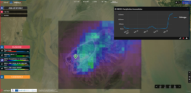
A dedicated dashboard to access data and processing resources is one of these key solutions, and FRIEND focused on this.
Each use case requires different datasets to be correlated to the flood change detection products, depending on the nature of the flood event (e.g., flash flood, flood caused by sea level rise, …). Also, real-time data provision is key to provide an efficient and operational service.
Demonstration of the service through the Char-Piya use case, where climate change strongly affects the seasonality of monsoon period and exacerbates coastal flooding.
Learn more about the service: (The service is still in the internal test/development environment; the production environment will be released soon)
Learn more about e-shape: www.e-shape.eu
A question? Contact the Helpdesk: https://helpdesk.e-shape.eu
This page has no comments.