Monitor coastal ecosystem
"People have been managing uses of marine and coastal ecosystems for centuries — from tribal authorities establishing marine tenure and taboos on resource use, to the modern era of complex governance. Yet today, the degraded condition of many seas and the overall decline in their diversity and productivity threaten our coastal communities and human well-being. The oceans' ability to maintain their diversity and productivity, and to provide a wide array of valuable services to people, are being compromised." [1].
For humans coastal areas are most important because they provide opportunities for tourism and recreation, transportation, fisheries, and mining, hence greatly contributing to the economy. Our growing reliance on coastal waters for food, trade and tourism requires these delicate ecosystems to be more closely monitored in order to guarantee their future sustainability. Quantitative and qualitative assessment of coastal areas is necessary to ensure their ecological richness and economic importance. Extent (spatial variability) and quality are key parameters in assessing coastal waters for development of management strategies by governmental institutions and environmental organizations.
Coastal areas are constantly subject to natural and anthropogenic stresses. Coastlines are highly dynamic and do not lend themselves well to be defined by strict spatial boundaries. The extent or spatial area may be influenced by several factors; natural events such as erosion or sediment supply from rivers, and the transportation and redistribution of sediments along the coast by tides, currents and storms (cyclones). Human stressors can alter these patterns. Draining, dredging, filling of wetlands for development and the construction of dikes for example, can lead to subsidence in coastal areas.
Coastal waters being physically, chemically and biologically affected must be assessed and monitored, providing the necessary information for management strategies. Traditionally this is done by analysis of water samples taken from monitoring stations and boats along the coast, but because of high costs and time constraints, in-situ monitoring is not carried out frequently enough. Satellite imagery, however, has proven to complement these in-situ measurements, providing a more detailed and accurate overview of the water quality encompassing a wider area.
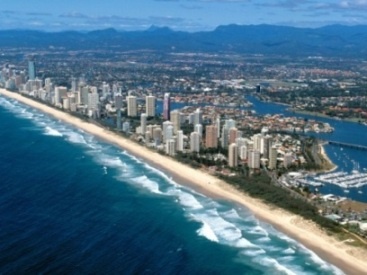
Gold Coast, Queensland, Australia. High densities of human
populations can put great stress on the coastal environment

ESA's Envisat satellite operated from 2002 until April 2012.
With 10 sophisticated optical and radar sensors, Envisat
continuously observed and monitored Earth’s land, atmosphere, oceans
and ice caps. It has been the largest civilian earth observation mission.
Credit: ESA
Many of the specific issues of coastal ecosystem monitoring and management can be addressed using Earth Observation services:
- work with contamination generated by waste treatment plants (E. Coli) analysis into thematic maps to advise the water quality to stakeholders.(canning mussel, oyster producers, shellfish farmers)
- red tides in relation with mussel farming plants; large amount of detritus that degenerated the sandy seabed where, other species such as. clams, oyster, razor shells, etc. inhabit.
- Bathymetry (water depth mapping) and the implication with the use of non-selective gears inside coastal areas which eventually destroy the seabed (removing the sand, rocks and breaking the coral reefs)....
- discharge of petroleum and chemical products from the sea or from inland industries such as mining or paper mills.
- run-off of fertilisers / nutrients leading to algal blooms and impacting water quality
- eutrophication associated with maritime discharge
- sedimentation from river estuaries resulting from farming and industrial practices inland.
- deposition from wave and tidal effects changing the coastal form and hence the local environment.
- damage to coral reefs and wildlife due to off-shore developments.
- reduction in habitats and biodiversity due to human coastal development linked to industry and tourism
- Draining, dredging, filling of wetlands for development and the construction of dikes for example, can lead to subsidence in coastal areas.
- Discharge from power stations cause threats to fish and coastal wildlife.
- Impact from HAB on bathing water/ recreation/tourism
References:
1. Taking steps towards marine and ecosystem-based management. UNEP, Nairobi. June 2011.
bathing water indicators |
| regulation under the terms of the EU Directive for “bathing water quality” |
| AquaMar |
detection harmful algal blooms (HBA) |
|
|
|
|
bathymetry |
| ecosystem modelling |
|
|
water temperature |
| aquaculture precison farming (health farmed fish) optimization of their feeding schemes and the impact of aquaculture on the surrounding marine coastal environment |
|
|
This page has no comments.