Success story on the use of shore type mapping with EO data
Shore type mapping using EO data in order to better plan and prioritize for the possible event of oil spill. |
|
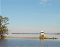
Oil spill have a negative impact on the environment. The consequences vary depending on the surrounding environment, but as the oil hit the shore-line an effective emergency response is necessary in order to reduce damage caused by oil spill. With a short time frame it is necessary to plan and prioritise actions to save the environment, including both vegetation and animals, in both the terrestrial and aquatic domain. For the municipality of Västerås (in Eastern Sweden) a shore-mapping was produced using optical EO data (10 meter spatial resolution) in combination with soil maps and other available in-situ databases. Mapping in EO data was performed in a 50 meter zone along the shore-line. |
|
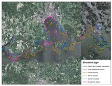
Various shore-line habitats require different response actions when oil spill occur. By using EO-data it is possible to prepare alternate rescue activities and also to prioritize what shore-lines to start with in the event of an oil-spill accident.
Effective emergency response is necessary in order to reduce damage caused by oil spill. With a short time frame it is necessary to plan and prioritise actions to save the environment. By combining EO data with in-situ databases it is possible to produce a decision support system that can be used to improve contingency planning. Shore types in need of urgent rescue services may be prioritised.
Shore type mapping with EO data is a cost-effective and flexible method with easy-to use results. The product is suitable for both regional and national scale and can be used to make operational planning more effective. Shore-type mapping can be important in the prevention of large damage to the shore-line and can potentially reduce the need for emergency activities along the full shore-line. The coming GMES Sentinel satellites will secure the continuation of useful EO data for this kind of product.
About Metria AB
Metria AB is a leading consultancy in the field of geographical information and geographical information technology. We help clients to collect, process and use geographical data as effectively as possible within their operations. The areas of application range from major infrastructure projects, to the construction of technical systems for geographical IT. Metria combines long experience and extensive knowledge of the sector with the innovative use of cutting-edge technology.
This page has no comments.