Throughout history the management of sediment in river basins and waterways has been an important issue. While ancient Egyptians were managing sediment in flood plains to provide the crops with nutrients, today the changing nature of sediment issues can be caused by various natural and anthropogenic stressors such as wind, rivers, volcanic eruptions, agriculture, aquaculture, forestry, sewage, dredging, draining, mining and dams. Earth observation has proven to be most valuable in assessing sedimentation dynamics through monitoring of various parameters such as total suspended matter, dissolved organic matter and turbidity.
From the perspective of remote sensing, water bodies are categorized in two classes: “case 1”and “case 2” waters. Case 1 is pristine azure coloured open ocean water where the optical properties are determined by the concentration of phytoplankton and its associated chlorophyll, which in case 1, is usually low. Since chlorophyll estimation from spectral reflectance is now relatively well-established, case 1 optical properties are relatively easily to analyze and thus relatively easy to model.
In contrast, Case 2 waters might be the muddy-brown to coffee-black riverine waters or the green waters loaded with chlorophyll, mixed with a little mud from the sea bottom as found in a coastal upwelling zone. Case 2 waters may have several other factors mixed together to create their optical characteristics. In addition to phytoplankton, these factors may include (inorganic) suspended sediments (like sand, clay or mud particles) and coloured dissolved organic matter (CDOM).
The colour of water is determined by the electromagnetic interaction of light with water components via absorption or scattering processes within the water column or at the sea surface or bottom. The optical properties of matter such as dissolved organic and inorganic substances and algae may all affect the water colour. Consequently it is possible to measure the colour (spectral reflectance) with the use of, for example, a satellite-based spectrometer.
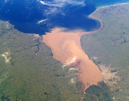
Sedimentation in Rio de la Plata
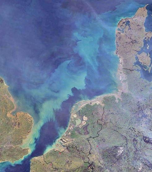
Credit: Dutch Coastal Waters
This detection of reflection is the basis for satellite-based mapping of total suspended matter (TSM), where TSM serves as an indicator for sediment transport applications. Accurate monitoring of TSM , also referred to as SPM (Suspended Particulate Matter), is most important for Environmental Impact Assessments (EIA) related to large-scale coastal development activities such as the Maasvlakte land reclamation (Maasvlakte 2) at the Port of Rotterdam in The Netherlands.
As it was expected that extensive sand mining operation to achieve this land reclamation, would probably enhance SPM concentrations in the coastal zone, the aim was to assess baseline conditions and changes in SPM concentrations. Remote sensing contributed to understanding SPM variation in the Dutch North Sea as its products, together with in-situ data, were assimilated in sediment transport models. In this case a set of parameters including SPM concentrations, error products and an approximation of optical depth was derived from MERIS data using IVM’s HYDROPT algorithm.
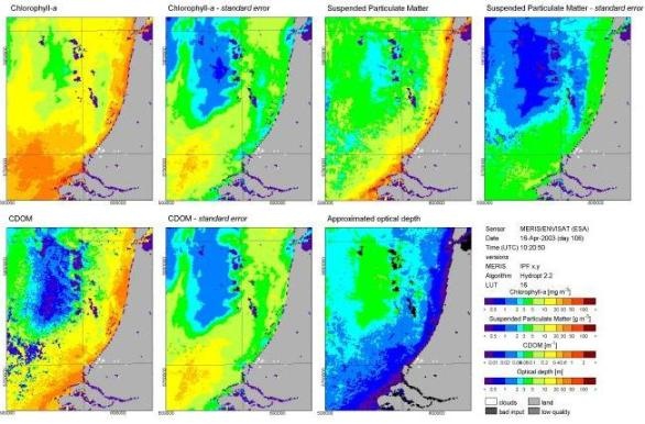
Suite of MERIS products as produced by VU-IVM from the HYDROPT algorithm.
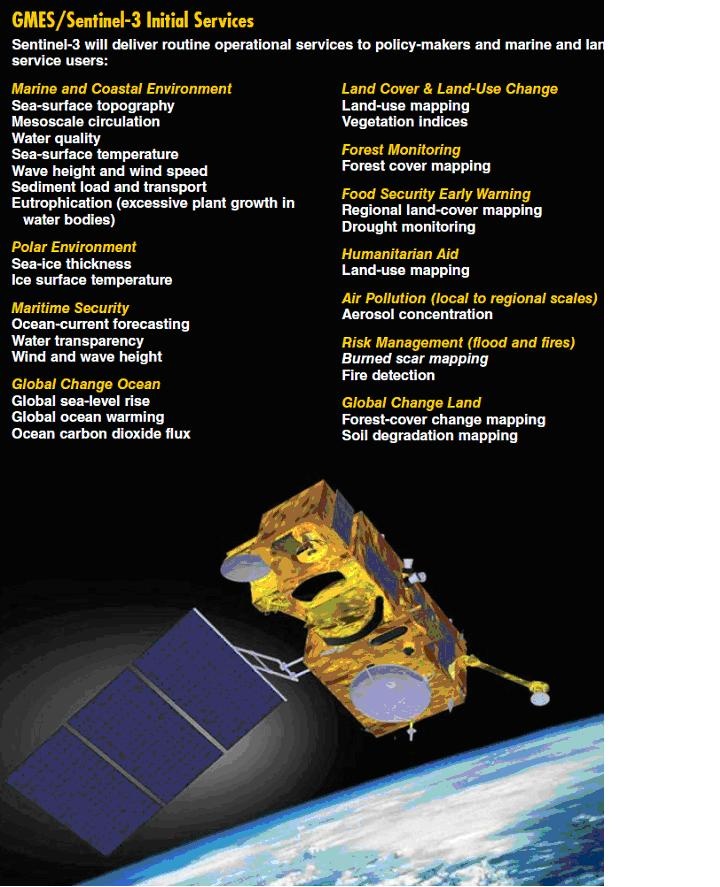
MERIS, the Medium Resolution Imaging Spectrometer was part of ESA's environment research satellite Envisat, which unfortunately stopped operating since April 2012. However, in the framework of the European Union-ESA Global Monitoring for Environment and Security (GMES) program, ESA is currently developing Envisat's successors; the Sentinel satellite constellation series. The EU Marine Core Service (MCS), the Land Monitoring Core Service (LMCS) and the ESA GMES Service Element (GSE) are collaborating to ensure continuity of data flow provided by the Sentinels. For MCS oceanography services are developed through three main projects; MERSEA (www.mersea.eu.org), ESA GSE Marcoast (gmes-marcoast.com) and Polarview (www.polarview.org) will deliver products on sea-surface topography, sea state and ecosystem characteristics of the oceans and European regional and shelf seas.
This page has no comments.