Sea ice and icebergs
Sea ice and icebergs pose a significant set of challenges for offshore oil and gas, and are becoming increasingly relevant as offshore interests extend into more extreme environments. The Arctic region in particular is becoming a focus for oil and gas activities as surveys suggest the presence of significant resources. According to the US Geological Survey, 30% of the world's gas and 11% of the world's oil deposits are estimated to lie beneath the Arctic regions[1].
Areas of current oil and gas interest include the Barents Sea (Shtockman), east and west Greenland, and the Beaufort and Chukchi Seas. Sea ice, which is formed from sea water, is not just a challenge in the polar regions. It is also present in temperate areas of oil and gas activity including the Sea of Okhotsk (Sakhalin), along the east coast of Canada and in the Caspian and Bohai Seas. Icebergs and ice islands, which unlike sea ice are calved from coastal glaciers and ice shelves and are thus formed from fresh water, have a quite different distribution and pose quite distinct challenges to oil and gas operations, particularly around Greenland, along the east Canadian coast, in the Barents Sea and, potentially, in the south Atlantic (Falkland Islands).
Within the Arctic, the pressure to exploit resources in this challenging environment is encouraged by declines in sea ice coverage. The most significant reductions in ice coverage over the last few decades have been in summer, with the result that many areas have been experiencing longer ice-free seasons and/or are becoming more accessible to marine vessels. While this has been creating opportunities for the oil and gas industry, in many Arctic regions sea ice remains a threat even in summer and there is a keen awareness that the challenges of operating in this region remain formidable. Remoteness and harsh operating conditions combined with strict standards on health and safety and protection of the environment create demanding conditions for entry into these areas, with earth observation being an essential and important component of the required package of technology.
Earth observation plays important roles in assessing ice conditions during several stages of the oil and gas lifecycle. Initially, earth observation is used to provide an Overview of the ice environment. This provides early indications of the types, characteristics and severity of ice hazards that need to be addressed in any exploitation of oil and gas. Earth observation can then be used to assist with design and planning, including design of offshore structures and planning of operational and ice management scenarios. Once activities take place within the area, starting with surveys, then Regional ice monitoring is required. This sets the overall context of ice conditions for a range of operations that may be taking place simultaneously at different locations across a lease region. Tactical ice support is required for operations that are particularly sensitive to ice conditions, including navigation in ice and drilling. The temporal and spatial sampling associated with tactical ice support is generally much more detailed than in the case of regional ice monitoring and in this case earth observation can be used in conjunction with ground and other non space-based remote sensing technologies.
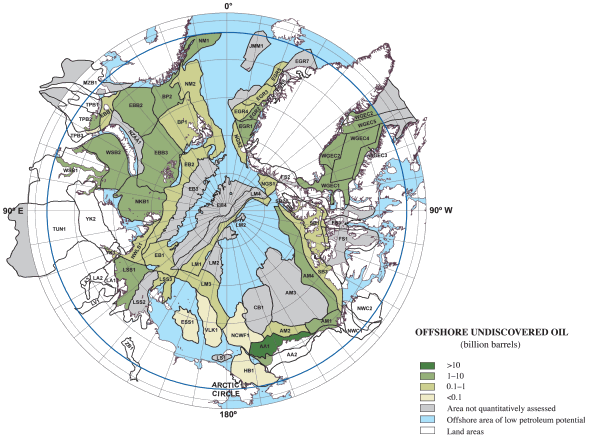
Undiscovered oil in the Arctic region, courtesy US Geological Survey, 2008 [1].
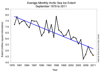
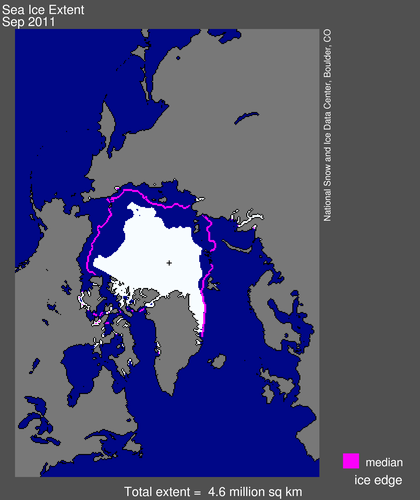
Above: reduction in minimum sea ice cover, 1979-2011. Below: sea ice extent in September 2011, at the time of minimum annual ice cover, shown along with the 1979 to 2000 median September extent in magenta. The black cross indicates the geographic North Pole. Both figures courtesy of the National Snow and Ice Data Center, Boulder, CO, USA.
References:
[1] Bird, K. J., Charpentier, R. R., Gautier, D. L., Houseknecht, D. W., Klett, T. R., Pitman, J. K., Moore, T. E., Schenk, C. J., Tennyson, M. E. and Wandrey, C. J., (2008), "Circum-Arctic resource appraisal; estimates of undiscovered oil and gas north of the Arctic Circle: U.S. Geological Survey Fact Sheet", 2008-3049, 4 p. [http://pubs.usgs.gov/fs/2008/3049/].
This page has no comments.