Application details page.
Regional ice monitoring
Regional ice monitoring, like weather forecasting, provides the context for a wide range of operations across a region. There can be several different types of operations taking place across the region, all requiring a basic knowledge of current ice conditions and the latest forecast. Regional ice information is typically conveyed to the offshore clients through the use of an ice chart, but this is normally augmented by text and/or voice information providing a forecast. National ice services also provide ice charts, but these are typically provided on a less frequent basis than is required by the oil and gas operator, and may be at significantly coarser spatial resolution, and so typically a custom regional ice chart will be provided from an onshore base hosting one or more ice analysts, often co-located with one or more weather forecasters.
The production of ice charts depends on having adequate availability of satellite imagery. The most useful is radar imagery because this is able to be used in cloudy, foggy and dark conditions.
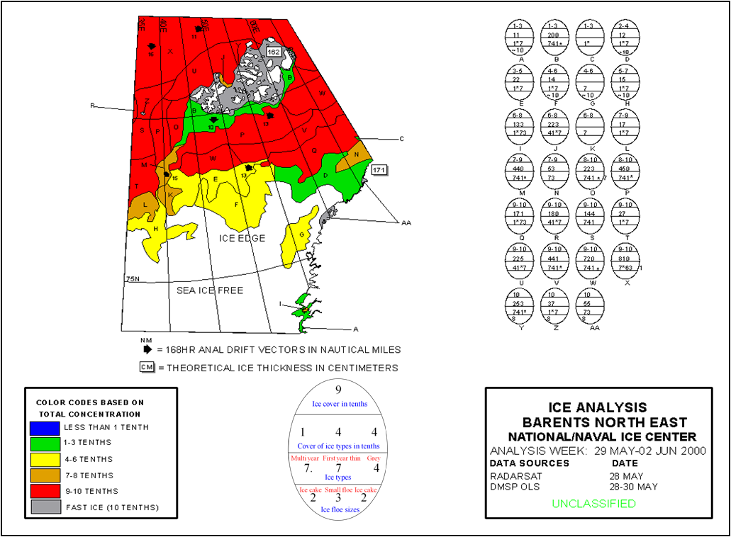
Example of an ice chart shown with explanation of "ice egg" symbol and earth observation data sources listed, from the US National Ice Center. An example "ice egg" with explanation is shown bottom centre. Regional ice conditions are typically conveyed in the form of an ice chart similar to this in format.
However, use will be made of any imagery that is available, including optical imagery when weather allows, as well as any reconnaissance data from offshore and coastal sites and ancillary information such as national ice charts. Having frequent updates of ice conditions from satellite imagery helps to ensure that there is consistency between ice charts and helps also with forecasting because the evolution of the ice (in position and condition) can be continually assessed. Careful use of different types of satellite imagery can enable the ice analyst to be able to optimise the observations for different types of ice conditions. In addition, having access to good quality regional weather forecasts are essential to providing good quality ice analysis and forecasting. The most important basic information that the analyst is looking for over the regional scale is that of total ice concentration and ice types (both in tenths of ice cover). Other information will also be provided when applicable or available, such as the presence of icebergs, land-fast ice margin, perhaps direction and speed of ice drift, and floe sizes.
This page has no comments.