| Name
|
Size
|
Creator |
Creation Date
|
Last Modification Date
|
Labels |
Attached To |
|
Microsoft Word 97 Document HCP-2101.doc |
51 kB |
Jeff Clark |
Jul 29, 2014 01:06 |
Jul 29, 2014 01:06 |
|
Page: Hatfield-2101: Lineament mapping
|
|
Microsoft Word 97 Document HCP-2301.doc |
51 kB |
Jeff Clark |
Jul 29, 2014 01:13 |
Jul 29, 2014 01:13 |
|
Page: Hatfield-2301: Identify discreet lithology
|
|
Microsoft Word 97 Document HCP-1214.doc |
51 kB |
Jeff Clark |
Jul 29, 2014 00:58 |
Jul 29, 2014 00:58 |
|
Page: Hatfield-1214: Identify restricted areas that must be avoided
|
|
Microsoft Word 97 Document HCP-1211.doc |
51 kB |
Jeff Clark |
Jul 29, 2014 00:47 |
Jul 29, 2014 00:47 |
|
Page: Hatfield-1211: Planning bridging through a tropical forest
|
|
Microsoft Word 97 Document HCP-1202.doc |
51 kB |
Jeff Clark |
Jul 29, 2014 00:15 |
Jul 29, 2014 00:15 |
|
Page: Hatfield-1202: Identify rivers, lakes and wet areas to apply safe setback distances
|
|
Microsoft Word 97 Document HCP-1201.doc |
51 kB |
Jeff Clark |
Jul 29, 2014 00:04 |
Jul 29, 2014 00:04 |
|
Page: Hatfield-1201: Identify up-to-date general land use patterns to plan access and apply safe setback distances.
|
|
Microsoft Word 97 Document HCP-1302.doc |
51 kB |
Jeff Clark |
Jul 29, 2014 01:05 |
Jul 29, 2014 01:05 |
|
Page: Hatfield-1302: Assess and map forest fire risk and provide situational awareness of fire occurrence.
|
|
Microsoft Word 97 Document HCP-1208.doc |
51 kB |
Jeff Clark |
Jul 29, 2014 00:38 |
Jul 29, 2014 00:38 |
|
Page: Hatfield-1208: Identify optimal seasonal land use to reduce permitting costs - in particular commercial and subsistance farming practices.
|
|
PNG File EO4OG Challenges environmental monitoring off-shor… |
50 kB |
Ariane Dubost Bonnet |
Apr 22, 2015 19:08 |
Apr 22, 2015 19:08 |
|
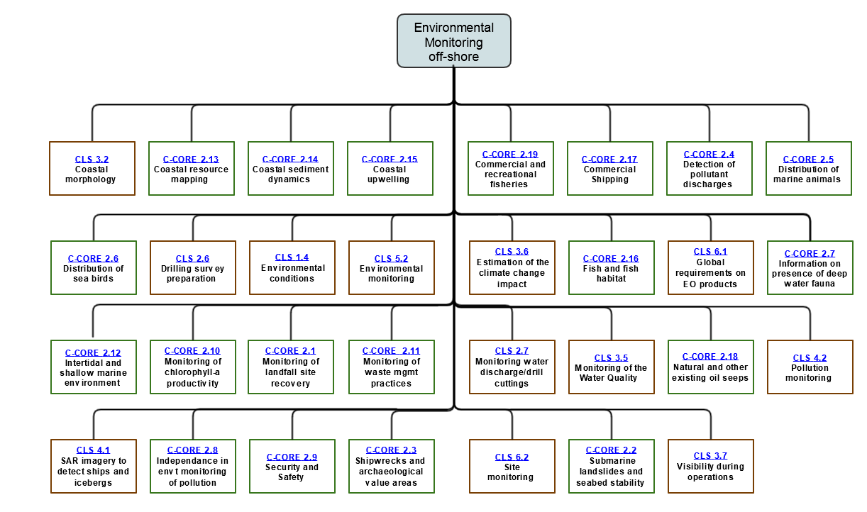
Page: EO4OG Challenges - Environmental monitoring off-shore
|
|
PNG File EO4OG Challenges metocean.png |
50 kB |
Ariane Dubost Bonnet |
Apr 23, 2015 08:41 |
Apr 23, 2015 08:41 |
|
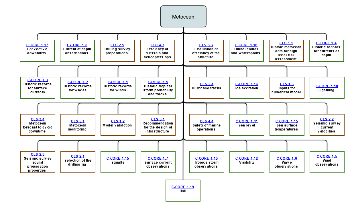
Page: EO4OG Challenges - Metocean
|
|
Microsoft Word 97 Document HCP-4207.doc |
50 kB |
Jeff Clark |
Jul 29, 2014 01:52 |
Jul 29, 2014 01:52 |
|
Page: Hatfield-4207: Understanding and predicting changes in hydrological processes
|
|
Microsoft Word 97 Document HCP-5401.doc |
50 kB |
Jeff Clark |
Jul 29, 2014 02:18 |
Jul 29, 2014 02:18 |
|
Page: Hatfield-5401: Monitor pipeline corridor hazards
|
|
Microsoft Word 97 Document HCP-4201.doc |
50 kB |
Jeff Clark |
Jul 29, 2014 01:46 |
Jul 29, 2014 01:46 |
|
Page: Hatfield-4201: Remediation and reclamation monitoring
|
|
Microsoft Word 97 Document HCP-1213.doc |
50 kB |
Jeff Clark |
Jul 29, 2014 00:57 |
Jul 29, 2014 00:57 |
|
Page: Hatfield-1213: Identify ice thickness and status for travel safety
|
|
Microsoft Word 97 Document HCP-4304.doc |
50 kB |
Jeff Clark |
Jul 29, 2014 02:01 |
Jul 29, 2014 02:01 |
|
Page: Hatfield-4304: Situational awareness information on water levels and lake extents and potential flooding
|
|
Microsoft Word 97 Document CLS_OFF.3.3.doc |
50 kB |
user-ff2aa |
Jul 29, 2014 12:13 |
Jul 29, 2014 12:14 |
|
Page: CLS-3.3: Evaluation of the efficiency of the structure
|
|
Microsoft Word 97 Document HCP-4302.doc |
50 kB |
Jeff Clark |
Jul 29, 2014 01:59 |
Jul 29, 2014 01:59 |
|
Page: Hatfield-4302: Floodplain mapping and understanding flood extent and flood frequency.
|
|
Microsoft Word 97 Document HCP-2501.doc |
50 kB |
user-ff2aa |
Jul 25, 2014 15:43 |
Jul 25, 2014 15:43 |
|
Page: Hatfield-2501: Characterization of surface/near-surface structural geological properties for infrastructure planning
|
|
Microsoft Word 97 Document HCP-3101.doc |
50 kB |
user-ff2aa |
Jul 25, 2014 16:19 |
Jul 25, 2014 16:20 |
|
Page: Hatfield-3101: Baseline and monitoring of areas with active faults and subsidence
|
|
Microsoft Word 97 Document HCP-4205.doc |
50 kB |
Jeff Clark |
Jul 29, 2014 01:49 |
Jul 29, 2014 01:49 |
|
Page: Hatfield-4205: Remediation monitoring related to agriculture impacts
|