| Name
|
Size
|
Creator |
Creation Date
|
Last Modification Date
|
Labels |
Attached To |
|
PNG File image-2024-1-16_13-3-54-1.png |
121 kB |
Francesco Casaril |
Jan 16, 2024 12:03 |
Jan 16, 2024 12:03 |
|
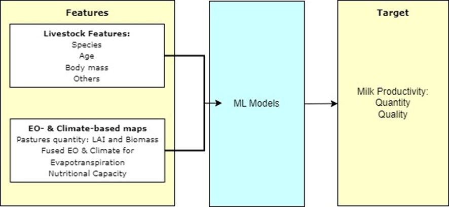
Page: Milk and Cattle (in weight) Productivity Estimation - capabilities
|
|
PNG File Insurance management.png |
110 kB |
Francesco Casaril |
Jan 15, 2024 13:00 |
Jan 15, 2024 13:00 |
|
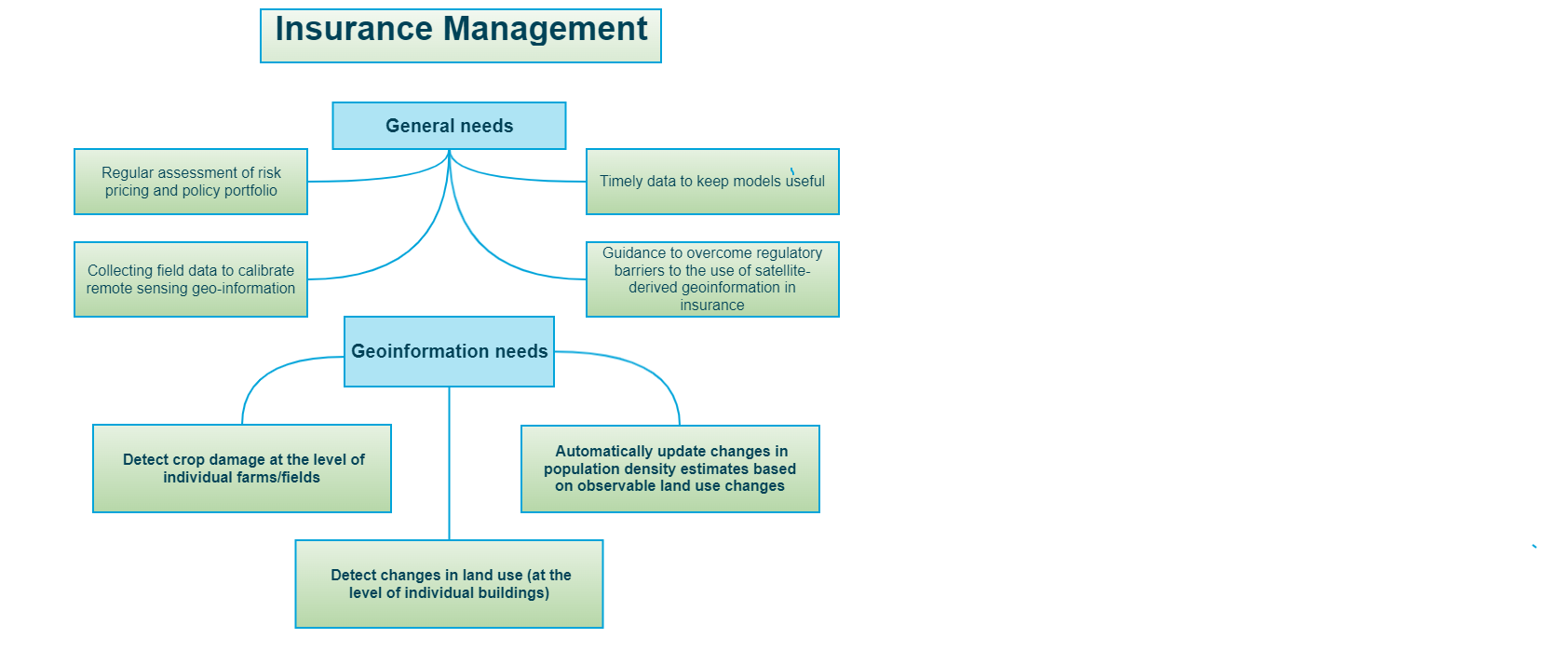
Page: Insurance Management
|
|
PDF File P18 Crop health (diseases and pests detection).pdf |
65 kB |
Francesco Casaril |
Jan 22, 2024 16:06 |
Jan 22, 2024 16:06 |
|
Page: Crop Health (Diseases and Pests detection) - gap analysis
|
|
PDF File P26 GHG emissions monitoring.pdf |
64 kB |
Francesco Casaril |
Jan 22, 2024 12:58 |
Jan 22, 2024 12:58 |
|
Page: GHG emissions monitoring - gap analysis
|
|
PDF File P23 Wildfire danger forecasting (Global Wildfire I… |
64 kB |
Francesco Casaril |
Jan 19, 2024 13:56 |
Jan 19, 2024 13:56 |
|
Page: Wildfires Danger Forecasting (Global Wildfire Information System) - gap analysis
|
|
PDF File P24 Identification of flood hazard areas.pdf |
63 kB |
Francesco Casaril |
Jan 19, 2024 13:24 |
Jan 19, 2024 13:24 |
|
Page: Identification of Flood Hazard Areas - gap analysis
|
|
PDF File P27 Estimation of above-ground carbon stocks in fo… |
62 kB |
Francesco Casaril |
Jan 22, 2024 16:15 |
Jan 22, 2024 16:15 |
|
Page: Estimation of Above-ground Carbon Stocks in Forests - gap analysis
|
|
PDF File P17 Land Cover Maps.pdf |
61 kB |
Francesco Casaril |
Jan 16, 2024 15:31 |
Jan 16, 2024 15:31 |
|
Page: Land Cover Maps - gap analysis
|
|
PDF File P22 Post wildfires monitoring (area and severity).… |
61 kB |
Francesco Casaril |
Feb 05, 2024 16:02 |
Feb 05, 2024 16:02 |
|
Page: Post Wildfires Monitoring (Area and Severity) - gap analysis
|
|
PDF File P01 Land use maps.pdf |
61 kB |
Francesco Casaril |
Jan 16, 2024 14:12 |
Jan 16, 2024 14:12 |
|
Page: Land use maps - gap analysis
|
|
PDF File P38 Surveillance of Oil and Gas Pipelines for Geoh… |
61 kB |
Francesco Casaril |
Feb 05, 2024 14:39 |
Feb 05, 2024 14:39 |
|
Page: Surveillance of Oil and Gas Pipelines for Geohazard and Ground Subsidence Vulnerabilities - gap analysis
|
|
PDF File P25 Identification of trends related to shifts in … |
60 kB |
Francesco Casaril |
Jan 19, 2024 13:41 |
Jan 19, 2024 13:41 |
|
Page: Identification of Trends Related to Shifts in Rainfall Patterns - gap analysis
|
|
PDF File P21 Drought monitoring at the assets level.pdf |
60 kB |
Francesco Casaril |
Jan 19, 2024 13:11 |
Jan 19, 2024 13:11 |
|
Page: Drought monitoring at asset level - gap analysis
|
|
PDF File P04 Tillage and crop residue cover practices.pdf |
60 kB |
Francesco Casaril |
Jan 22, 2024 15:43 |
Jan 22, 2024 15:43 |
|
Page: Tillage and Crop Residue Cover Practices - gap analysis
|
|
PDF File P08 Trees counting.pdf |
60 kB |
Francesco Casaril |
Jan 29, 2024 13:28 |
Jan 29, 2024 13:28 |
|
Page: Trees Counting - gap analysis
|
|
PDF File P36 Monitoring highway and railway networks.pdf |
60 kB |
Francesco Casaril |
Jan 29, 2024 13:36 |
Jan 29, 2024 13:36 |
|
Page: Monitoring Highway and Railway Networks - gap analysis
|
|
PDF File P02 Crop type and acreage mapping.pdf |
59 kB |
Francesco Casaril |
Jan 22, 2024 14:46 |
Jan 22, 2024 14:46 |
|
Page: Crop Type and Acreage Mapping - gap analysis
|
|
PDF File P31 Coastal erosion.pdf |
59 kB |
Francesco Casaril |
Jan 18, 2024 08:55 |
Jan 18, 2024 08:55 |
|
Page: Coastal erosion - gap analysis
|
|
PDF File P05 Green biomass and yield estimation.pdf |
59 kB |
Francesco Casaril |
Jan 16, 2024 11:37 |
Jan 16, 2024 11:37 |
|
Page: Green biomass and yield estimation - gap analysis
|
|
PDF File P30 Satellite-derived bathymetry for port and coas… |
59 kB |
Francesco Casaril |
Jan 22, 2024 09:24 |
Jan 22, 2024 09:24 |
|
Page: Satellite-Derived Bathymetry for Port and Coastal Monitoring - gap analysis
|