| Name
|
Size
|
Creator |
Creation Date
|
Last Modification Date
|
Labels |
Attached To |
|
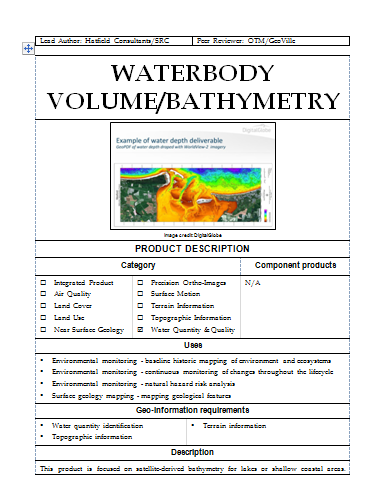
PNG File snip waterbody volume.PNG |
56 kB |
administrator |
Apr 15, 2015 11:30 |
Apr 15, 2015 11:31 |
|
Page: EO4OG Products On-shore
|
|
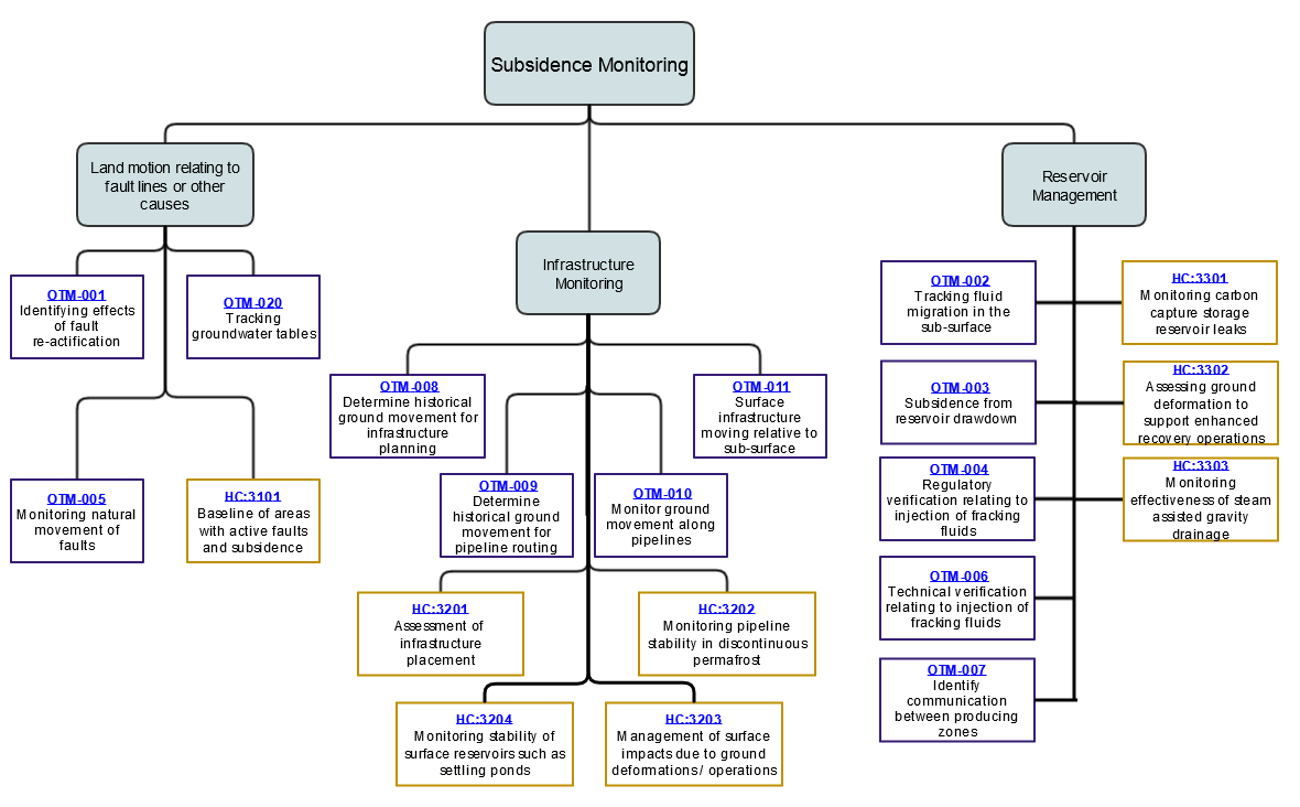
File subsidence monitoring challenges |
56 kB |
Ariane Dubost Bonnet |
Apr 22, 2015 12:40 |
Apr 22, 2015 12:40 |
|
Page: EO4OG Challenges - Subsidence monitoring
|
|
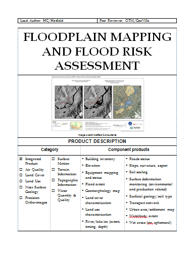
PNG File snip floodplain mapping.PNG |
56 kB |
administrator |
Apr 15, 2015 11:30 |
Apr 15, 2015 11:31 |
|
Page: EO4OG Products On-shore
|
|
PNG File subsidence monitoring challenges.png |
56 kB |
Ariane Dubost Bonnet |
Apr 22, 2015 12:40 |
Apr 22, 2015 12:40 |
|
Page: EO4OG Challenges - Subsidence monitoring
|
|
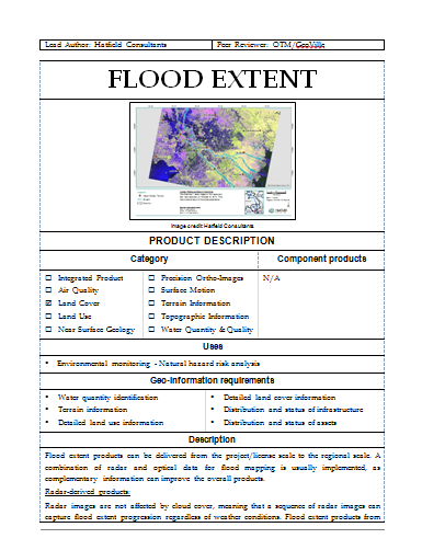
PNG File snip flood extent.PNG |
55 kB |
administrator |
Apr 15, 2015 11:30 |
Apr 15, 2015 11:31 |
|
Page: EO4OG Products On-shore
|
|
File OTM Challenges 4 |
55 kB |
administrator |
Jul 13, 2014 15:39 |
Jul 13, 2014 15:39 |
|
Page: OTM Challenges 4
|
|
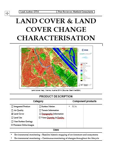
JPEG File Land cover characterisation snip.JPG |
53 kB |
administrator |
Apr 15, 2015 11:30 |
Apr 15, 2015 11:31 |
|
Page: EO4OG Products On-shore
|
|
PDF File EO4OG-Minutes- 26 Mar 14 Webex teleconf OTM+hatfie… |
52 kB |
user-59139 |
Apr 09, 2014 19:13 |
Apr 09, 2014 19:13 |
|
Page: On-shore Project - OTM
|
|
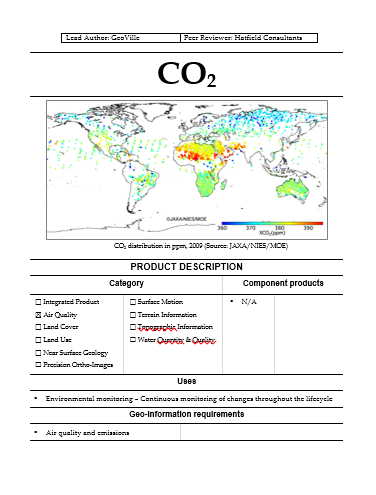
PNG File CO2 Snip.PNG |
52 kB |
administrator |
Apr 15, 2015 11:30 |
Apr 15, 2015 11:31 |
|
Page: EO4OG Products On-shore
|
|
Microsoft Word 97 Document HCP-1301.doc |
51 kB |
Jeff Clark |
Jul 29, 2014 01:03 |
Jul 29, 2014 01:03 |
|
Page: Hatfield-1301: Identify sensitive habitat to minimise and manage impacts of activities
|
|
Microsoft Word 97 Document HCP-1209.doc |
51 kB |
Jeff Clark |
Jul 29, 2014 00:42 |
Jul 29, 2014 00:42 |
|
Page: Hatfield-1209: Identify land parcel boundaries for impact compensation
|
|
Microsoft Word 97 Document HCP-1203.doc |
51 kB |
Jeff Clark |
Jul 29, 2014 00:18 |
Jul 29, 2014 00:18 |
|
Page: Hatfield-1203: Identify areas with soft sediments to plan access and assess hazards
|
|
Microsoft Word 97 Document HCP-1215.doc |
51 kB |
Jeff Clark |
Jul 29, 2014 01:00 |
Jul 29, 2014 01:00 |
|
Page: Hatfield-1215: Identify UXO related hazards
|
|
Microsoft Word 97 Document HCP-2201.doc |
51 kB |
Jeff Clark |
Jul 29, 2014 01:09 |
Jul 29, 2014 01:09 |
|
Page: Hatfield-2201: Identify geological structure through landform
|
|
Microsoft Word 97 Document HCP-1204.doc |
51 kB |
Jeff Clark |
Jul 29, 2014 00:24 |
Jul 29, 2014 00:24 |
|
Page: Hatfield-1204: Assess forest characteristics to plan access and assess hazards
|
|
Microsoft Word 97 Document HCP-1206.doc |
51 kB |
Jeff Clark |
Jul 29, 2014 00:30 |
Jul 29, 2014 00:30 |
|
Page: Hatfield-1206: Identify steep slopes to assess potential constraints to access
|
|
Microsoft Word 97 Document HCP-1102.doc |
51 kB |
Jeff Clark |
Jul 28, 2014 23:54 |
Jul 28, 2014 23:54 |
|
Page: Hatfield-1102: Identify rock-strewn areas to avoid point loading
|
|
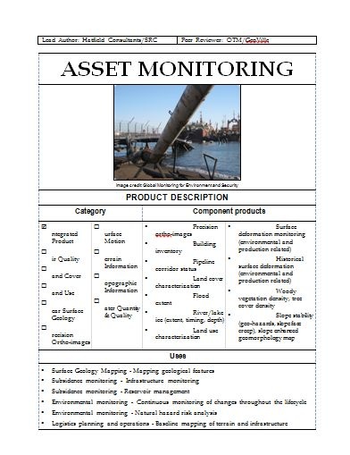
JPEG File snip asset monitoring.JPG |
51 kB |
administrator |
Apr 15, 2015 11:30 |
Apr 15, 2015 11:31 |
|
Page: EO4OG Products On-shore
|
|
Microsoft Word 97 Document HCP-1302.doc |
51 kB |
Jeff Clark |
Jul 29, 2014 01:05 |
Jul 29, 2014 01:05 |
|
Page: Hatfield-1302: Assess and map forest fire risk and provide situational awareness of fire occurrence.
|
|
Microsoft Word 97 Document HCP-1202.doc |
51 kB |
Jeff Clark |
Jul 29, 2014 00:15 |
Jul 29, 2014 00:15 |
|
Page: Hatfield-1202: Identify rivers, lakes and wet areas to apply safe setback distances
|