Through a co-development process and close collaboration with potential and existing users of biodiversity information in four countries situated in one of the world's most biodiverse region, the Tropical Andes, we were able to optimize biodiversity conservation by tailoring Essential Biodiversity Variables to policy needs and collaboratively preparing and publishing an EBV-based indicator that directly addresses the conservation and policy requirements of these nations.
| Sponsor | Project | Solution provider | User |
|---|---|---|---|
|
| Protected Area Managers, Scientists, Environmental Assessment Agencies in Colombia, Peru, Ecuador, and Bolivia, National Biodiversity Strategies and Action Plans. |


- Asses biodiversity
- Land ecosystem
- Monitor forests
- Monitor land use/landcover
Protected Area Managers, Scientists, Environmental Assessment Agencies in Colombia, Peru, Ecuador, and Bolivia, National Biodiversity Strategies and Action Plans.
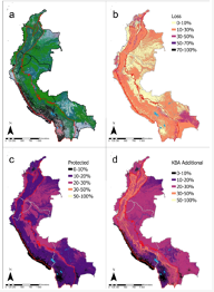
This ecosytem level indicator focuses on the Tropical Andes region of Colombia, Peru, Ecuador, and Bolivia, using both potential (pre-industrial) and recent (~2010) distribution maps of terrestrial ecosystem types. We measure long-term ecosystem loss, representation of ecosystem types within current protected areas, and quantify the additional representation offered by protecting Key Biodiversity Areas (KBAs). The mapped pixel resolution for the EBV-hypercube in the Data Portal is 270 m.

DEIMS-SDR and EcoSense provide services for users to document and visualise information on long-term observation facilities as well as data gathered at these locations. EcoSense provides a on-stop interface to access this information and to visualise collected information. User stated "it is a very important new step for DEIMS-SDR and for eLTER!!! Congratulation."
When dealing with Earth Observation data pipelines as well as scientific analysis the use of in-situ data as well as understanding the context of observation is an important issue. This applies e.g. for the integration and use of in-situ datasets to produce meaningful value added EO data products. Providing services to register and document long-term observation facilities as well as the data collected and providing means to visualise and access them in an easy manner was one of the main aims of the mySite pilot. This should allow for the integration of in-situ data as well as EO data products generated for a given area. This not only supports scientific workflows but also supports the management of selected areas, e.g. protected areas, to support daily management.
Information on long-term in-situ data is provided via multiple platforms ranging from local offline data descriptions to national network scale metadatabases. Thus, in-situ datasets are not ubiquitously available but must be made findable and accessible, yet conserving associated data rights and licenses. In addition, information on the observation context needs to be provided in order to plan and conduct scientific analysis or plan targeted observation. This also includes to provide sufficient and comprehensive information on relevant long term data sources and observation sites across different domains and biogeographic gradients as well as to provide access to easily retrievable, localised (=site-based), and standardised validated biodiversity and ecosystem data. In order to address these challenges, DEIMS-SDR has been developed to document long-term observation facilities and datasets as well as EcoSense as a visualisation and access interface to support the user needs.
DEIMS-SDR is a established registry to document and access information on long-term observation facilities and the resulting datasets. DEIMS-SDR allows to manage and update this information once new data are created and data streams are made available. Via the web-interface information can be discovered using pre-defined filters, search by keywords or using the map search. This information together with EO data products developed by the mySpace pilot are visualised and made available through the EcoSense platform, which is the second service provided and is a one-stop window for users to access information. In addition, a REST-API for DEIMS-SDR as well as targeted applications, like crocotile to link in-situ sites to Sentinel tiles have been developed. By including accurate and up-to-date information in DEIMS-SDR, site coordinators benefit from a greater visibility of their site, platform and data, which can help to attract funding to support site investments.


Learn more about the service:https://deims.org; https://ecosense.biosense.rs; https://elter-crocotile.datalabs.ceh.ac.uk/; https://www.youtube.com/watch?v=w8IizVvSYVs
Learn more about e-shape: www.e-shape.eu
A question? Contact the Helpdesk: https://helpdesk.e-shape.eu
This page has no comments.