Bathymetric data or underwater topography are vital to marine commerce, industry, environmental management and monitoring. Bathymetry is traditionally charted via shipboard echo sounding or via airborne LADS (Laser Airborne Depth Sounding) and then interpolated into the DEM data sets.
Optical remote sensing methods for mapping bathymetry offer an alternative which can be more cost effective and efficient, especially over large areas of clear water bodies. Remote sensing techniques are non-invasive and particularly attractive for remote areas. Applications of sophisticated processing of satellite or airborne imagery in clear, shallow coastal zones allows for derivation of accurate underwater topography. Remote sensing products can serve as stand-alone information in inaccessible areas or can be used in combination with traditional in-situ data to generate a variety of information layers.
Satellite sensors: QuickBird, WorldView, IKONOS, MERIS
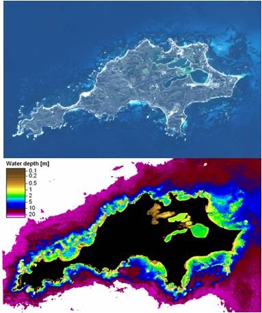
Bathymetry mapping Rottnest Island with QuickBird , West Australia
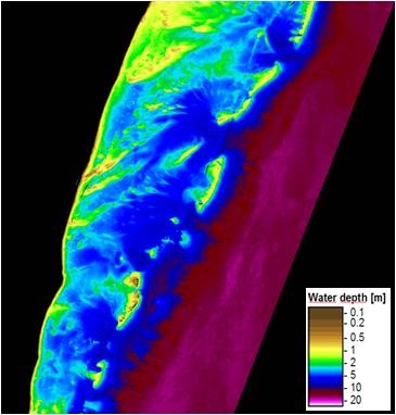
Bathymetry mapping with WorldView 2, Mexico
Application Area | Description | Keywords |
|---|---|---|
Multispectral satellite based water depth mapping | Bathymetry, multispectral | |
SAR and multispectral bathymetry mapping[2] | SAR, underwater topography |
References:
[1] Sabine Ohlendorf, Andreas Müller, Thomas Heege, Sergio Cerdeira-Estrada and Halina T. Kobryn (2011): "Bathymetry mapping and sea floor classification using multispectral satellite data and standardized physics-based data processing", Proc. SPIE 8175, 817503; doi:10.1117/12.898652
[2] Pleskachevsky, A., Lehner, S., Heege, T., Mott, C. (2011): Synergy and fusion of optical and synthetic aperture radar satellite data for underwater topography estimation in coastal areas. Journal of Ocean Dynamics, Special Issue – MREA. DOI 10.1007/S10236-011-0460-1
Products | Ext. Source | Descriptions | Product Standards | Ref. Project |
|---|---|---|---|---|
|
|
|
|
|

Topic | Description | Keywords | Reference |
|---|---|---|---|
|
|
|
|
This page has no comments.