Technology of aquatics optical remote sensing
Principles
In the broadest sense, remote sensing is the measurement or acquisition of information of an object or phenomenon, by a recording device that is not in physical or intimate contact with the object. In practice, remote sensing is the utilization at a distance (as from aircraft, spacecraft, satellite, or ship) of any device for gathering information about the environment. Passive optical sensors detect natural energy (radiation) that is emitted or reflected by the object or scene being observed. Reflected sunlight is the source of radiation measured by passive optical sensors.
In marine and aquatic environments, the sunlight spectrum is modified on its way through the atmosphere, the water surface, and the water body. In each of these boundary layers sunlight is absorbed, scattered, and reflected in a specific manner, depending on the wavelength. As a result, the reflected light carries spectral information about the particular composition of these matters.
Data processing
Different remote sensing data processing methods are available to retrieve thematic information from remote sensing data. With mathematical and statistical methods the spectral information is analysed. Pixels are compared to specific class signatures and assigned depending on the similarity. Physics-based retrieval algorithms model the complex light interactions with the atmosphere and the water body based on physical principles. Once set up, these optical models do not require manual adaptation in order to generate map products and are often independent of ground truth measurements. These algorithms are very flexible and may be applied worldwide and are very under all conditions covered by the optical models upon which they are based.
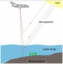
Remote sensing process of water bodies (airborne)
Principles
In the broadest sense, remote sensing is the measurement or acquisition of information of an object or phenomenon, by a recording device that is not in physical or intimate contact with the object. In practice, remote sensing is the utilization at a distance (as from aircraft, spacecraft, satellite, or ship) of any device for gathering information about the environment. Passive optical sensors detect natural energy (radiation) that is emitted or reflected by the object or scene being observed. Reflected sunlight is the source of radiation measured by passive optical sensors.
In marine and aquatic environments, the sunlight spectrum is modified on its way through the atmosphere, the water surface, and the water body. In each of these boundary layers sunlight is absorbed, scattered, and reflected in a specific manner, depending on the wavelength. As a result, the reflected light carries spectral information about the particular composition of these matters.
Data processing
Different remote sensing data processing methods are available to retrieve thematic information from remote sensing data. With mathematical and statistical methods the spectral information is analysed. Pixels are compared to specific class signatures and assigned depending on the similarity. Physics-based retrieval algorithms model the complex light interactions with the atmosphere and the water body based on physical principles. Once set up, these optical models do not require manual adaptation in order to generate map products and are often independent of ground truth measurements. These algorithms are very flexible and may be applied worldwide and are very under all conditions covered by the optical models upon which they are based.
Remote sensing process of water bodies (airborne)
Restrictions
Restrictions occur whenever the object-specific signals are masked or interfered with in any ambiguous manner, with regards to both the sensor resolution and retrieval methods. Therefore only few general restrictions can be identified and most restrictions can only be determined with site-specific observations, sensors used, or algorithms applied. Examples of general restrictions are clouds masking optical signals reflected from the earth surface or direct reflections from the water surface resulting in intense contributions to the recorded signal sun glitter.
Examples of case-dependent restrictions are:
- Intermediate sun glitter sun glitter effects can be corrected only if the radiometric and spectral resolution of the sensor is adequate and the processing approach supports respective correction procedures (> example).
- The spatial resolution of the sensor must be higher than the spatial heterogeneity of the target areas to be mapped. Sub-pixel classification of surfaces is only possible for a very restricted number of spectral end members. At the very least, every contribution of members not implemented into the model will create inaccuracies.
- The spectral behaviour of optical classes must differ significantly from each other with respect to the sensor’s spectral resolution. E.g. Chlorophyll and dissolved organic matter (Gelbstoff) cannot be estimated independently if the sensor’s spectral and radiometric resolution is insufficient and/or the ecosystem specific absorption spectra are too similar for an independent, quantitative estimate.
References:
This page has no comments.