Oil spills
Every year thousands of oil spills occur as a result of accidents or natural disasters. Even deliberate spills take place during war time or to save money. Although large spills are published and known to the public, small spills such as resulting from emptying billage tanks before or after entering a port happen every day. Oil spills affect the environment, devastate natural resources and public health and disrupt the economy. To mitigate and manage oil spill impacts, satellite remote sensing has proven to be a valuable technology. Information derived from remote sensors is used to improve decision-making and rapid response. Satellite remote sensing can be applied to various modes of oil spill control, including large area surveillance, site specific monitoring and strategic assistance and emergency control.
The spatial and frequent coverage of Earth observation satellites allows to cost effectively complement cost intensive aerial surveillance by patrol aircrafts. Satellite remote sensing is used to detect and monitor size, extent and location of oil spills, as well as providing information on wind, current and waves to predict oil movement.
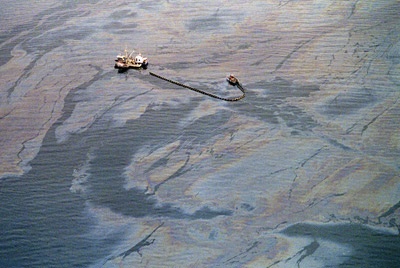
A crew attempts to skim oil from the surface of the waters of Prince William Sound following the 1989 Exxon Valdez oil spill. Credit: Chris Wilkins/AFP/Getty images
Remote sensing radars transmit pulsed microwave (radio wave) beams which are bounced off and altered by objects and surfaces they encounter. The origin and strength of this backscatter is received by satellite sensors and provides information on for example unusual texture which may be due to spilt oil. Identification of oil spills requires in general high resolution sensors, although wide area coverage is very important for initial monitoring and detection. Currently there exist various satellite remote devices including optical, SAR and laser fluorosensors. Laser fluorosensors very accurately detect oil spills on shores, ice and snow and are capable of identifying what type of oil has been spilled. They require however relatively cloud free conditions. SAR sensors do not depend on weather conditions or day/night cycle.
Depending on the type of oil spill various types of satellite sensors can be applied. Non-accidental oil discharges such as incidental losses from vessels due to hull or equipment leaks, as well as oil discharged intentionally during de-ballasting and tank-cleaning activities are smaller than accidental spills. They are however very frequent and contribute much more to the overall introduction of oil to the marine environment than accidental spills. Non-accidental spills are therefore of increasing international regulatory concern. Accidental spills are much less frequent, but involve much larger releases of oil and require rapid and effective emergency response.
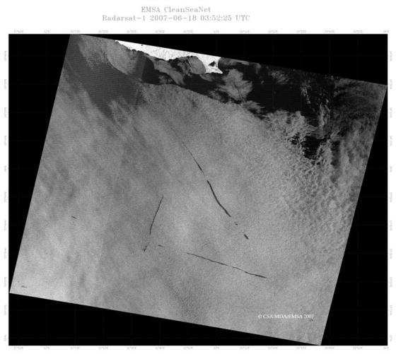
Radarsat 1 image of oil spill off the south coast of Cyprus, Credit: CSA/MDA/EMSA 2007
To mitigate ship sourced pollution there has been established a European wide system for oil slick detection based on Synthetic Aperture Radar (SAR) images from satellites. This service is called CleanSeaNet (CSN) and uses information provided by satellites such as RADARSAT-1 and RADARSAT-2. ENVISAT ASAR has also been used until it was no longer available and continuity of service will be guaranteed with data from TerraSAR-X (DLR) and CosmoSkyMed (ASI) and the currently developed Sentinel-1. CleanSeaNet offers a near real time marine oil spill detection service free of charge to all EU Member States, Candidate countries and EFTA Coastal States In case of oil slick detection, an alert message is sent to end users and final verification of possible oil slicks and the polluter is then carried out by surveillance patrol vessels. SAR imagery is also used for vessel detection. The integration of vessel tracking data, vessel detection and auxiliary Earth Observation products allows for aggregated maritime information and greatly contributes to the reduction of illegal oil spills at sea and the prosecution of illegal activities.
Globally there are a number of organizations and programs involved to mitigate the impact of oil spills. In the case of a major oil spill disaster in European and adjacent waters, EMSA, conducting the CleanSeaNet service, together with the International Charter (Space and major disasters) will provide rapid access to satellite derived information about the areas affected by or at risk of serious pollution. The International Charter consists of multiple agencies such as ESA, CNES, NOAA and USGS and aims to provide a unified system of space data acquisition and delivery to those affected by natural or man-made disasters. More examples of organizations and programs involved in oil spill monitoring and management involve OSPAR, IMO, UNEP, FAO and EEA.


BP Oil Spill Provides Showcase for Earth Observation Satellites | Article on BP oil spill | Oil spill, Satellites | |
Website - Oil pollution; a global environmental challenge | Oil pollution, Near real time monitoring | Kongsberg Satellite Services | |
A GIS approach to mapping oil spills in the marine environment | Research paper on how SAR and GIS technologies can significantly improve identification or even classification of oil spills allowing making the final product - oil spill distribution maps. | Oil spill, Mapping, SAR | ScanEx |
Article on pollution monitoring | Marine, oil spill mapping, pollution | ScanEx | |
Research Paper on monitoring oil spills | Oil and Gas | ScanEx | |
Research paper highligting that SAR onboard the Envisat satellite is an excellent tool for studying oil seeps through observation oil slicks floating on the sea surface | Oil and gas, SAR, Envisat, Mapping, | ScanEx | |
Research paper on Mapping of Oil Slicks Polluting Sea Surface Based on Space Radar Data (The Caspian Sea) | Oil slicks, Sea surface, Pollution, Mapping | ScanEx | |
Use of the wide-swath synthetic aperture radar images for mapping sea oil pollution | Research paper containing discussions of results obtained through application of the Radarsat and Envisat satellite radar data for oil pollution monitoring of the Yellow Sea, East China Sea and Black Sea | Envisat, Oil pollution, Mapping | ScanEx |
MAPPING OIL SPILLS IN THE CASPIAN SEA USING ERS-1/ERS-2 SAR IMAGE QUICK-LOOKS AND GIS | Research paper presents an approach and methodology for oil spill mapping in the Caspian Sea based on analysis of the ERS-1/ERS-2 SAR image quick-looks | SAR, Mapping, Oil spills, | SciElo |
Research paper describes enhancements to the ESI concept | Oil spill, Mapping, ESI, Remote sensing |
| |
Article describing the world's largest oil spills | Oil spills, Mapping | Geology | |
TerraSAR-X Image Of The Month: Tracking The Catastrophic Oil Spill | Article on TerraSAR - X | Oil spills, Mapping, Tracking, Gulf of Mexico | SpaceMart |
Web mapping techniques applied to the visualization of ESA satellite products | Research paper presents the work that has been conducted by ESA during the last year in the field of OpenGis Web Mapping Technologies using in particular the IONIC software component suite (Requires purchasing) | Oil spill, Mapping | ScienceDirect |
Research Paper - A synergetic concept for an object based and multi temporal mapping and classification system for terrestrial oil spill pollution using a test area in West Siberia is presented in this paper (Requires purchasing) | Oil spill, Mapping, Pollution | ScienceDirect | |
Research paper focusing on a subset of these applications, namely aquaculture detection, coastline mapping, ship surveillance and oil spill monitoring. | Mapping, ship detection, surveillance, Oil spill | GIS Service | |
Conference Presentation showcasing the German surveillance system | Oil spill, Mapping , airborne , satellite, verification, evidence | BFG-Germany | |
Research Paper: Remote Sensing of the Environment (2005), Review of Methods and state of the art. | oil spills. | Brekke and Solberg, | |
Research Thesis | Oil Spill | Faculty of Geo-Information Science and Earth Observation | |
Oil Spill Detection and Classification by ALOS PALSAR at Vietnam East Sea | Research paper - preliminary results of oil spill detection in the East Sea using the ALOS PALSAR data | Oil spill, Detection | International Federation of Surveyors, FIG |
A Method for Quantitative Mapping of Thick Oil Spills using Imaging Spectroscopy; |
|
| Roger Clarke, Gregg Swayze et al, USGS 2010 |
Identification of oil spills based on ratio of alternating polarization images from ENVISAT | Research paper (need to purchase to view full text) | Oil spill, SAR, polar images | IEEE |
Article on Oil Spill monitoring and ship detection service | Oil spill, ship detection | ESA | |
Rearch paper - From national towards pan european multi user services | Oil spill, ship detection | Asian Association on Remote Sensing | |
Case study - highlights the potential of wide-swath synthetic aperture radar (SAR) imagery for the regional oil pollution monitoring | Oil spill, SAR images, Oil pollution | Cite Seer beta | |
Presentation on sea oil pollution using ERS and ENVISAT data | Oil spill, Oil pollution, ship detection | DISP | |
Proof-of-concept study on oil spill detection services: User requirements and feedback | Research Paper describes the user requirements and feedback collected by one CEO application proof-of-concept study conducted by the Tromsø Satellite Station in Norway and dealing with the detection of oil spill at sea (need to purchase to view full text) | Oil spill; pollution, SEA, SAR, CEO, user requirements | Science Direct |
Research paper describes the technology being implemented to improve oil spill monitoring and surveillance, to ensure SAR data acquisition and processing and to develop geographic information systems in support of spill response decision making | Fast Oil Spill Detection, Oil Slicks, Remote Sensing, Radar, Monitoring | URlib | |
Article on modern airborne maritime surveillance systems | Maritime, OiL spill, surveillance | Hydro International | |
Research paper on remote sensing and GIS for oil spill contingency planning | Remote Sensing, Geographic Information System, Oil spill | ISDE | |
Ship detection on ENVISAT ASAR data: results, limitations and perspectives | Research paper addresses specific ship detection algorithms which have been developed for various demanding applications and extensively tested on ASAR data | ENVISAT data, Oil spill, ship detection | ESA |
Research paper examines the characteristics and applications of differentsensors | Oil Spill Surveillance, Disaster Management, Contingency Planning, Remote Sensing, Space-borne Sensors, Airborne Sensors | MDPI | |
New and Innovative Equipment and Technologies for the Remote Sensing and Surveillance of Oil In and Under Ice - published 2005 | Oil spill , Ice , Gas flux , lighttouch, GPR | U.S. - MMS , Statoil, Dickens Assoc Ltd. | |
Presentation on advances in SAR oceanography from ENVISAT and ERS missions | Oil spill, Detection, SAR | ESA | |
Environment Sensitivity Analysis for Near Shore Region Using GIS GIS BASED ESI MAP | Study proposes an example of ESI guideline containing fishery data around Abashiri city facing the Sea of Okhotsk. | Oil Spill Accident, ESI (Environment Sensitivity Index) Map, Socio-economic information | Research Centre for Social Management Systems |
Article on oil spill with RADARSAT images | Oil Spill, RADARSAT images | Canadian Space Agency | |
Article on oil spill with links to related ESA articles | Oil Spill, Earth observation, Monitor | GMES Info | |
Monitoring Oil Spills Offshore the United Arab Emirates Using Multi Satellite Data | Research paper discusses sea oil pollution detection, statistics and | Oil Spill, Detection, Mapping, Arabian Gulf Waters | ICSRS |
Presentation on remote sensing | Remote sensing, oil spill | TUDelft | |
Article on how satellites measure many properties of the Earth's oceans from space | Remote sensing, oil spill | NOAA | |
|
|
|
|
This page has no comments.