To address subsidence issues and close the technical gap of its existing systems, Italian utility Hera needed a solution to monitor and detect ground movement across its network.
Monitor urban areas
Assess infrastructures monitoring
Born in 2002 out of the aggregation of 11 municipal companies operating in Emilia-Romagna, first corporation of its kind nationwide, over time Hera has embarked on a journey of consistent and balanced growth, incorporating other companies active in the same areas. Hera, publicly listed since 2003, is now among the nation's largest multi-utilities, working mainly in the environment (waste management), water (aqueduct, sewerage and purification) and energy (electricity, gas distribution and sales, energy services) sectors.
Within the panorama of public services in Italy, the Hera Group's leadership can easily be recognised in a few figures: almost 9,000 employees who meet the needs of 4.3 million citizens in 330 municipalities in Emilia-Romagna, Friuli-Venezia Giulia, Marche, Tuscany and Veneto.
Planetek Italia is an Italian company, established in 1994, which employs 50 men and women, passionate and skilled in Geoinformatics, Space solutions, and Earth science. We provide solutions to exploit the value of geospatial data through all phases of data life cycle from acquisition, storage, management up to analysis and sharing. We operate in many application areas ranging from environmental and land monitoring to open-government and smart cities, and including defence and security, as well as Space exploration and satellite missions. The main activity areas are:
|
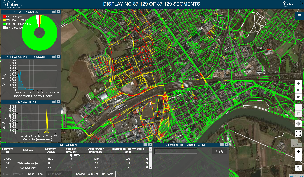
Using Satellite Radar Data to Improve Operations Created through a partnership between Hexagon Geospatial and Planetek Italia, Rheticus is a cloud-based service that uses satellite radar data processing to provide accurate, up-to-date information about ground instability and displacements in a pipeline network to give the utility advance warnings of possible problems. It then issues alerts to aid in prioritizing inspection and maintenance activities, increasing efficiency and lowering total management costs. Hera, which values sustainability and the efficient application of resources, was particularly enthusiastic about the automated capabilities of Rheticus. “While it makes use of sophisticated algorithms and techniques, these are all done behind the scenes so we can focus on the answers and not the mechanics,” a Hera spokesperson said. |
Like many utility companies that manage water and sewage infrastructure, Hera constantly monitors subtle ground movement on its 3,852 miles of pipeline. Subsidence “doesn’t need to be dramatic to be destructive and costly,” said a Hera spokesperson. “Ground motion of even a few centimetres around buried pipelines can cause leaks in the pipes, and not just water and sewer pipes — gas, electricity, and telecommunications can all be affected. These leaks can then accelerate the erosion around the critical area, damaging service and possibly creating larger problems.”
While Hera uses sophisticated equipment like smart meters and traffic monitoring systems to address ground movement and subsidence problems, its approach was reactive, responding to citizens’ calls reporting issues after they had already occurred. The reality is that subtle ground movement is difficult to detect in advance, even by trained inspectors. To address subsidence issues and close the technical gap within its existing systems, Hera needed a solution to monitor and detect ground movement across its network. In Rheticus, the Italian multi-utility found a way to use satellite radar data to conduct real-time surface monitoring, reduce manpower for inspections, and minimize maintenance costs. |
|
This page has no comments.