Mapping of Impervious Areas and Soil Sealing
Soil sealing describes the covering of the soil surface by materials such as concrete thereby changing the nature of the soil into behaving as an impermeable medium. EO-based products
describing impervious areas and sealing levels are oriented towards an inventory and monitoring of artificial surfaces in relation to other land cover types. Typically the products contain at least land cover information and degrees of soil sealing.
Typical spatial resolutions are 5–50 m (MMU of 0.25 ha for artificial surfaces and 1 ha for non-urban classes), resulting in scales of 1:25.000. Monitoring for the period from the late 1970s to the late 1990s relies mostly on medium resolution data which does not allow for much thematic detail, but provides enough information for a regional analysis.
The temporal resolution (update frequency) is usually once every 3–5 years, but is limited only by the availability of satellite data (available globally every few days/weeks, depending on
geographic latitude, cloud cover and data acquisition schedule) and the ancillary, non-EO (demographic, economic) datasets.
The spatial and thematic accuracies of soil sealing products depend mostly on the urban mapping products they are based on the urban mapping products they are based on.
Maps of the sealing levels of the soil help understand the impact on the environment of urban expansion and development of related technical infrastructures. Disturbance patterns with different intensity result from transport, noise, exploitation of natural resources, waste dumping and pollution. The products contribute to analysing and describing land take trends in relation to population development as well as the drivers, pressure, state and impact of land consumption. Various types of thematic analysis can be performed when combining these products with other data such as demographic and economic data, spatial indicators on the exposure to natural hazards, or climate changerelated risks, policy-relevant indicators on essential spatial planning parameters (e.g. land consumption per capita, pressure on protected areas), etc.
Similarly to the basic urban mapping products, the ever-increasing amount of relatively affordable medium- and high-resolution data will ensure the continuity of this type of product long into the future. The benefits from the Sentinel-2 mission in particular are similar to those highlighted in earlier sections.
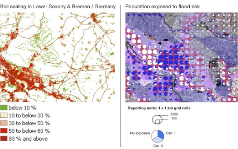
[1] Example of a soil sealing map
[2] Illustration of how the soil sealing map can be used in combination with socio-economic data and risk data to provide a map of the population exposed to flood hazard. Credits: GeoVille.
References:
ESA 2013, Earth Observation for Green Growth: An overview of European and Canadian Industrial Capability
Products | Ext. Source | Descriptions | Product Standards | Ref. Project |
|---|---|---|---|---|
|
|
|
|
|
|
|
|
|
|---|---|---|---|
|
|
|
|
Topic | Description | Keywords | Reference |
|---|---|---|---|
|
|
|
|
This page has no comments.