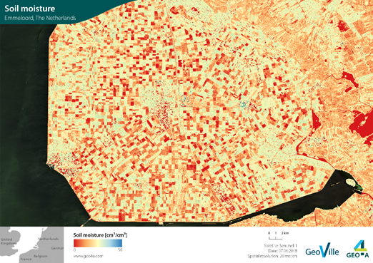
High resolution soil moisture based on Sentinel-1 (Emmeloord, The Netherlands) (Source: GeoVille/Geo4A) | ||||||||||
Category | ||||||||||
|
|
|
|
| ||||||
PRODUCT DESCRIPTION | ||||||||||
Soil moisture plays an important role for the environment and the climate system. Affected by precipitation, temperature, soil characteristics and more factors, soil moisture refers to water stored in the soil. It influences hydrological and agricultural processes as well as runoff generation and many other processes. Earth observation provides global, seamless surface soil moisture information, measuring the moisture content of the top five centimetres of soil. Based on this, root zone soil moisture can be modelled. This seamless observation is a clear advantage compared to point based in-situ measurements, and recent developments allow to obtain also high-resolution satellite soil moisture observations. The ESA Climate Change Initiative (CCI) Soil Moisture provides a +40-year dataset of daily soil moisture [m³/m³] at 25 km, updated yearly. Based on active and passive sensors this consistent global dataset provides valuable information at larger scales but does not meet the need for real time soil moisture information at field level. The Copernicus Global Land Service provides Surface Soil Moisture (SSM) and the Soil Water Index (SWI) with a resolution of 1 km for the layer over Europe and 12,5 km at global scale, every day. Recently, also higher resolution (e.g. 100 m as well as 10 m) near real time soil moisture products are being made available using the Copernicus Sentinel Constellation and offered by commercial Earth observation companies. The data may be used as an indicator for insurance portfolio’s drought/flood monitoring and loss adjustment procedures to benchmark the areas affected/unaffected by risk event. A more accurate and robust underwriting with additional rating instruments to be applied based on the soil moisture data. | ||||||||||
PRODUCT SPECIFICATIONS | ||||||||||
Main processing stepsHigh resolution soil moisture is estimated by a multi-sensor, time-series data-based approach. Data from various satellites with different spatial resolutions is combined. Additionally, the NDVI is used as a proxy because of its sensitivity to surface soil moisture patterns. Statistical downscaling procedures using Deep Learning methods are applied to combine data with different spatial resolutions and transfer them to higher resolutions. By using this method, data can be generated also on a local, regional or national level and at a higher spatial resolution than the European and global layers. | ||||||||||
Input data sourcesOptical: n.a. Radar: Sentinel-1, SMAP, MetOp ASCAT Supporting data: in-situ data | ||||||||||
Spatial resolution and coverageSpatial resolution: 10m – 25km Coverage: Local/regional/national/global level Availability: globally available | ||||||||||
Accuracy / constraints5-10% RMSE / not applicable in densely forest areas | ||||||||||
LimitationsCurrently available products indicate the surface soil moisture of the top few centimetres soil from coarse to high spatial resolution. However, it is not possible to directly observe root zone soil moisture. | ||||||||||
Frequency / timelinessFrequency: various time steps and long historic archives Timeliness: near-real time | ||||||||||
Delivery / output formatData type: GIS-ready data formats; Raster; API (depending on customer needs) File format: NetCDF, GeoTIFF, CSV | ||||||||||
AccessibilityFreely available products are provided e.g. through the Copernicus Land Monitoring Service (https://land.copernicus.eu/global/themes/vegetation). Products from ESA’s CCI Soil Moisture initiative with global coverage are open and freely available for registered users (https://www.esa-soilmoisture-cci.org/). Products with higher resolution are commercially available on demand from EO service providers. | ||||||||||
CHALLENGES ADDRESSED - USE CASE(S) | ||||||||||
Product Development:
Product Sales:
Underwriting:
Loss Adjustment:
Claims Handling:
| ||||||||||

Overview
Community Forums
Content Tools
This page has no comments.