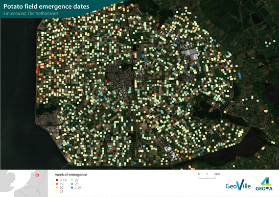
Week of emergence for potato crops (Source: GeoVille) | ||||||||||
Category | ||||||||||
|
|
|
|
| ||||||
PRODUCT DESCRIPTION | ||||||||||
The date of emergence of plants is important to determine the vegetation period and in understanding of the crop’s development. This service provides information on the emergence of a specified crop type, indicating in which week the plants emerge above the ground on a certain field. Date of emergence provides underwriters with a monitoring tool for the portfolio to observe possible losses due to insured/non-insured risks (e.g. wrong sowing dates, improper inputs/technology application, etc.). Early or late planting dates may be rated higher (e.g. +10-20%). While assessing the damage, the information on crop’s emergence may assist the surveyor in determining the actual vegetation stage at time of risk event. This will assist in better precision for assessment of the actual loss. Furthermore, the data serves as input for other services such as crop growth monitoring and crop growth models. | ||||||||||
PRODUCT SPECIFICATIONS | ||||||||||
Main processing stepsThe product is based on the processing of multi-spectral optical and radar satellite imagery. Consistent time series over the starting of the vegetation period is essential. The comparison of different time steps allows to differentiate between agricultural fields with emerged crop from other land cover such as bare soil. The identification of the week of emergence is based on the analysis of vegetation indices such as the NDVI or LAI. | ||||||||||
Input data sourcesOptical: Sentinel-2, Landsat 8 Radar: Sentinel-1 Supporting data: meteorological data, field boundaries | ||||||||||
Spatial resolution and coverageSpatial resolution: 10 m Coverage: Local/Regional level Availability: globally available | ||||||||||
Accuracy / constraintsThematic accuracy: > 85 % depending on in-situ availability Spatial accuracy: field level | ||||||||||
LimitationsEmergence date can only be confirmed if a sufficient amount of satellite observations is available. Optical data can be limited by cloud coverage, thus a hybrid approach using also radar data as well as additional modelling supports the timely detection. | ||||||||||
Frequency / timelinessFrequency: various time steps Timeliness: around six weeks after start of growing season | ||||||||||
Delivery / output formatData type: GIS-ready data formats; Vector; Raster; API (depending on customer needs) File format: GeoTIFF; Shapefile (depending on customer needs) | ||||||||||
AccessibilityCommercially available on demand from EO service providers. | ||||||||||
CHALLENGES ADDRESSED - USE CASE(S) | ||||||||||
Product Development:
Product Sales:
Underwriting:
Loss Adjustment:
| ||||||||||

Overview
Community Forums
Content Tools
This page has no comments.