Page tree

Versions Compared

Key

  • This line was added.
  • This line was removed.
  • Formatting was changed.

Content Layer
id353362182
Content Column
tabbed-blockstrue
id353362181
Content Block
nameApplication
id353362108

Glaciers

Section
Column
width40%

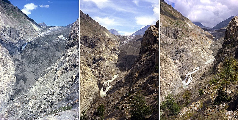
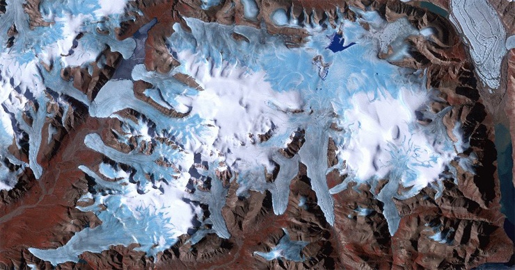
Currently there is a general consensus that the Earth's average temperature is increasing. Glaciers are key indicators of climatic changes as they show an enhanced and well recognisable reaction to even small climatic fluctuations. One of the consequences of global warming is the rising of global mean average sea level which mainly results from melt water from glaciers, ice sheets, ice caps, icebergs, and sea ice. In Europe several glaciers have completely disappeared as a result from higher temperatures. Receding glaciers can cause massive flooding and affect stream flow and temperature of mountainous sheds which in turn affects habitats of various flora and fauna species. Glacier- and permafrost-related hazards such as glacier floods and avalanches represent a continuous threat to human lives and infrastructure. Disasters associated with the glacial and periglacial environment can cause thousands of casualties and massive economic loss in one event. 

The effects of climate change are being investigated on a global scale. Satellite remote sensing proves to be a very valuable technology in the attempt to understand the impact of melting glaciers. Various remote sensors operating in different spectral regions (visible, infrared, microwave) have been widely used to study parameters such as ice thickness, surface ice velocities, and changes in surface elevation over time.

Column
width60%

The Aletsch Glacier or Great Aletsch Glacier is the largest glacier in the Swiss Alps in the canton of Valais.


Monitoring of glaciers has been organised within the Global Terrestrial Network for Glaciers (GTN-G) which is operated by the world glacier monitoring service (WGMS). The WGMS, in turn, is part of the Global Climate/Terrestrial Observing Systems (GCOS/GTOS) and aims to collect and publish mass-balance data of glaciers obtained by direct glaciological and geodetic methods as a contribution to the GTN-G. Other organisations involved in glacier remote sensing include FAO, IPCC, UNEP, NOAA,  ICSU (WDS), IUGG IACS)UNEPUNESCOWMO,  International Glaciological Society, International Work Group on Geospatial Analysis of Glaciated Environments (GAGE)International Union for Quaternary Research (INQUA)Scientific Committee on Antarctic Research (SCAR), SCAR Working Group on GlaciologyWorld Glacier Monitoring Service.

Earth observation satellites are being used for preliminary inventory of glaciers including aerial extent and position of large crevasses, and for mapping and monitoring glacial variations especially at the glacier margins and terminus location. Examples of satellite sensors that have been used for glacial monitoring include Landsat TM and ETM, Terra ASTER, SPOT Pan and XS, IRS Pan and LISS, ERS SAR and Radarsat SAR. 

Section
Column
width60%

Because it is suggested that melting glaciers and ice caps might provide an even larger contribution to the global sea level rise in the coming decades than the two continental ice sheets Greenland and Antarctica, earth observation satellites are used to generate more complete and representative data to get a better understanding of this phenomenon. From the mid-1970s satellite images have been compiled in the Satellite Image Atlas of Glaciers of the World to establish baseline information for all glaciated areas world wide. ESA is currently operating the GlobGlacier project, a new data user element activity within ESA’s Living Planet program.

The main objective of this project is to map glaciers from key regions all over the world and to generate digital glacier outlines in large quantities in order to fill data gaps in currently existing databases Global Land Ice Measurements from Space (GLIMS) and the World Glacier Inventory (WGI).

Column
width40%
 
Glaciers and ice caps on Ellesmere Island, Canadian Arctic. Credits: ASTER Image from 19.07.2000 - Courtesy of GLIMS
Content Block
nameProducts
id353362126
Advanced Tables - Table Plus
columnAttributesstyle="width:120px;",style="width:120px;",style="width:300px;",style="width:300px;",style="width:180px;"

Products

Source

Descriptions

Product Standards

Ref. Project

glacier products


based on high resolution multi-spectral optical satellite data and SAR data

  • Glacier Outlines
  • Snow / Ice Area Map
  • Late Summer Snow Line
  • Ice Velocity Map
  • Glacier Dammed Lakes


Cryoland

Content Block
nameSuccess Stories
id353362142
Advanced Tables - Table Plus
columnAttributesstyle="width:250px;",style="width:250px;",style="width:250px;",style="width:250px;"


Content Block
nameReferences
id353362162
Advanced Tables - Table Plus
columnAttributesstyle="width:250px;",style="width:600px;",style="width:150px;",style="width:100px;"

Topic

Description

Key words

References