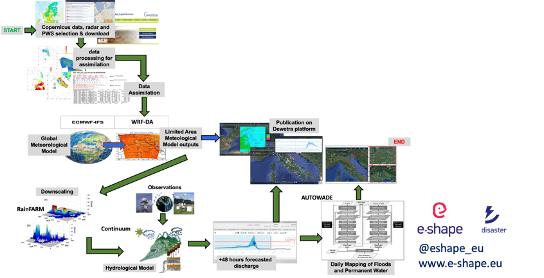
The WRF-3DVAR model (available 330UTC, Oct. 24th, 2021) showed very good predictive capability concerning the timing and the location of most intense rainfall phenomena over Catania and Siracusa provinces in Sicily, thus enabling also very accurate discharge peaks and timing predictions for the creeks hydrological network peculiar of eastern Sicily Based on the WRF-3DVAR model predictions, the daily run of the AUTOWADE tool, using Sentinel-1 (S1) data, was anticipated with respect to the schedule to quickly produce a flood map (S1 acquisition performed on Oct. 25th, 2021, at 5.00 UTC, flood map produced on the same day at 13.00 UTC). Moreover, considering that no S1 images of eastern Sicily were available during the period Oct. 26-30, 2021, an ad hoc tasking of the COSMO-SkyMed satellite constellation was performed, again based on the on the WRF-3DVAR predictions, to overcome the S1 data latency The resulting automated operational mapping of floods and inland waters was integrated with the subsequent execution of the hydraulic model TELEMAC-2D |