Page tree

Versions Compared

Key

  • This line was added.
  • This line was removed.
  • Formatting was changed.

...

Content Layer
id353386303


Content Column
tabbed-blockstrue
width100.0%
id2047532052


Content Block
nameSummary
id2119714053

MoutainNow is an international crowdsourcing platform for sharing mountain observations in real-time. Designed for use by the public, MountaiNow offers a live map of the latest mountain conditions and hazards (e.g. crevasses, rock falls) – to improve mountain safety and better adapt to climate change. The App is live on the appstores and web at www.mountainow.net


SponsorProject Solution providerUser


Image Added

Image Added

Image Added


Mountain enthusiasts (individuals, friends, families) and groups (e.g. Alpine Clubs), Environmental services (e.g. public/private offices, safety/accident prevention institutions), Tourism industry (e.g. sport equipment retailers, tourism offices)


Content Block
nameTaxonomy
id2119719941

Travel & Tourism

Emergency Services

Local & Regional planning


Content Block
nameUser profile
id2047532054


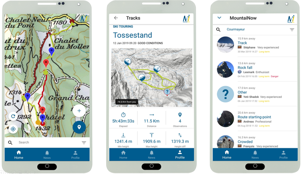
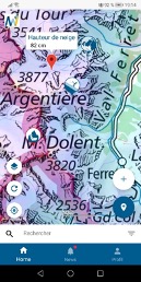
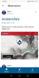
-       Mountain enthusiasts/groups (individuals, friends and families who enjoy mountains e.g. Alpine Clubs and associations)

-       Environmental services (e.g. national parks, public/private environmental offices, safety & accident prevention institutions)


Examples:

-       Members of the Swiss Alpine Club (150,000 members)

-       Gran Paradiso National Park, Italy (park management authorities)


Image Added              Image Added

We create and provide data solutions for the farmers and industries that farmers rely on. Farmers, agri-cooperatives, agri-consultants, smart farming service providers, insurance organizations and companies, food & beverage companies, CAP stakeholders (farmers and paying agencies), traders and trading companies are some of already engaged users or potential users/consumers.

Usage of alpha version of Agrowth in the current running cultivation period for the cotton in Greece from several users:

  1. Neuropublic - Gaia Epixirein | Agri-consultants
  2. Farmers Cooperative of Orchomenos
  3. Cotton Farsala | Farmers Cooperative
  4. Farmers Cooperative of Thessaly "THESgi"

Neuropublic - OchraVine ControlImage Removed    Image Removed       Image Removed      Image Removed


Agrowth platform combines Earth Observation data along with pertinent vegetation indices, soil and weather data. It makes use of state of the art in Artificial Intelligence in order to support smart farming using EO data. Specifically, it provides a crop monitoring service which offers information and/or actionable advice at the parcel level.

In the current alpha version, the available services per parcel are:

  1. Phenology estimation: It estimates the current phenology stage of crop and the fuzzy transition of them in the course of time. Specifically, it provides the percentage of completion of each stage and it indicates the major and minor phenological stage in order to highlight this fuzziness of transition between of them.
  2. Weather Forecast: It visualizes the max and min ambient temperatures per parcel and it interplays with risk.resagri.eu. The user can be transferred at the click to ResAgri’s detailed weather information.
  3. Yield prediction: It predicts the yield in kg/ha, weeks earlier from the harvest.
  4. Vegetation Indices: It provides charts for the evolution of the vegetation indices NDVI, NDWI, PSRI and some crop specific indices.

Furthermore, there are some services for a quick overall view of the state of all available parcels on the map of user.

  1. Overlay Satellite Images: It allows to overlay satellite images (RGB or NDVI) over the users’ parcels for a chosen acquisition date and area of interest.
  2. Phenology Stage: It colors the outline of each parcel with a color equivalent to its major phenology stage.
  3. Crop Classification: It colors the outline of each parcel with a color equivalent to its crop.
  4. Daily sowing map: It provides a heatmap for the sowing period of cotton which estimates daily the risk of sowing in a 2km x 2km spatial grid.

   Image Removed  Image Removed    

    Image Removed      

Content Block
nameService description
id2047532055
Content Block
nameCustomer experience
id2047532056

Testimony from CottonFarsala about daily sowing map

“Several farmers went on with sowing their parcels even though the sowing maps indicated otherwise. The conditions of the short future were unfavorable and the farmers had to sow for a second time a couple of weeks later.”

Vaggelis Georgolopoulos - Agronomist | Cotton Farsala

Content Block
nameNeed
id2047532058
  • "I need to know when is the best time for sowing”
  • “I need to know when to apply pix (plant growth regulator) on my cotton fields”
  • “I need to know my expected yield early in the year so I can take relevant action”
  • “I need to know the occurrence of an imminent extreme weather event and the appropriate action I should take given the growth stage of my cultivation”

Next-Generation Mountain Equipment. This is what MountaiNow is about. A live map combining community observations with satellite data - to keep you safe and help you make the most of your hiking, climbing, and ski touring adventures.  Join us now ! www.mountainow.net


Image Added


Content Block
nameCustomer experience
id2047532056


“Meets a real need. Unique App” Bruno, user, on Google Play.

« Simple and fast. Just the tool the mountain community needs to share on safety. I strongly recommend it!” Jean-Christophe, user, on Google Play

“The possibility to transmit in real-time localised hazards to the community of mountaineers is truly unique and of major importance. This is why we have established a key partnership with MountaiNow to foster crowd-sourcing and participate in its future development” Jean Micol, President Swiss Alpine Club, Diablerets.

“We have actively participated, from the beginning, in the testing of MountaiNow. MountaiNow is an innovative app which, exploiting technology, exponentially increases the knowledge of conditions as well as the safety of users” Stefano Cerise, Chief Inspector, Surveillance Corps, Gran Paradiso National Park


Content Block
nameNeed
id2047532058


Climate change is changing mountains, creating new needs for safety and adaptation. MountaiNow – a live map of mountain hazards for the Alps and the world – was created to meet those needs.

Highly innovative is the combination of real-time in-situ crowdsourcing, space insight, and guided navigation – offering a new/unique set of actionable information.


Content Block
nameChallenges
id2047532059


Timely geo-localized information about mountain hazards is still hard to get. Most of the time, people go to the mountains missing critical information. Public/Private actors make decisions missing critical data – impacting thousands of lives and costing the outdoor/tourism/insurance industry millions.

 One key feature of MountaiNow is to allow for the easy capture and real-time sharing of critical hazard observations such as rock-falls, landslides, snow/ice avalanches, glacial lakes, and high river-discharge. Observations of hazard precursor signs such as glacier melt or fractured snow-pack are also included.

Content Block
nameChallenges
id2047532059
The main challenge observed it to "monitor and provide effective, timely and frequent consultation over large agricultural areas.”


Content Block
nameResults
id2047532060


Benefits are multi-dimensional:  Social – Saved lives and less accidents or situations of distress; Economic – higher number of clients for tourism services; and Environmental/Scientific – advanced monitoring of mountain areas and related hazards (e.g. landslides, glacial lake outbursts).

     Image Added   Image Added

The benefits of the Agrowth platform are the following:

  • It estimates the current phenology stage of crop and the fuzzy transition of them in the course of time. → Producer/Farmer knows every time in what stage his/her crop is and he/she is able to take action.
  • It provides a heatmap for the sowing period of cotton which estimates daily the risk(high/medium/low) → Producer/Farmer has an indication about the right time of sowing, he/she is able to catch the possible sweet early window of April for cotton sowing.
  • It predicts the yield in kg/ha, weeks earlier from the harvest. → Producer/Farmer has a good estimation of yield weeks earlier.
  • It provides charts for the evolution of the vegetation indices NDVI, NDWI, PSRI and some crop specific indices. → Producer/Farmer has a good indication in order to monitor the vegetation health and the moisture of the crop.
  • It visualizes the max and min ambient temperatures per parcel and it interplays with risk.resagri.eu. →  Producer/Farmer has access to ResAgri’s detailed weather information in a 2km x 2km spatial resolution.

Image Removed     Image Removed


Content Block
nameReferences
id2047532061

Learn more about the service: http://agrowth.beyond-eocenter.eu/ www.mountainow.net

Learn more about e-shape: www.e-shape.eu

A question? Contact the Helpdesk: https://helpdesk.e-shape.eu

    Image Removed   Image RemovedImage Removed