MoutainNow is an international crowdsourcing platform for sharing mountain observations in real-time. Designed for use by the public, MountaiNow offers a live map of the latest mountain conditions and hazards (e.g. crevasses, rock falls) – to improve mountain safety and better adapt to climate change. The App is live on the appstores and web at www.mountainow.net
| Sponsor | Project | Solution provider | User |
|---|---|---|---|
|
|
| Mountain enthusiasts (individuals, friends, families) and groups (e.g. Alpine Clubs), Environmental services (e.g. public/private offices, safety/accident prevention institutions), Tourism industry (e.g. sport equipment retailers, tourism offices) |


Travel & Tourism
Emergency Services
Local & Regional planning
- Mountain enthusiasts/groups (individuals, friends and families who enjoy mountains e.g. Alpine Clubs and associations)
- Environmental services (e.g. national parks, public/private environmental offices, safety & accident prevention institutions)
Examples:
- Members of the Swiss Alpine Club (150,000 members)
- Gran Paradiso National Park, Italy (park management authorities)
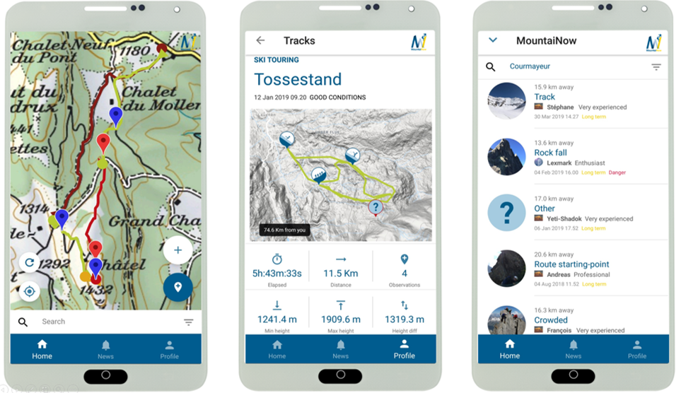
Next-Generation Mountain Equipment. This is what MountaiNow is about. A live map combining community observations with satellite data - to keep you safe and help you make the most of your hiking, climbing, and ski touring adventures. Join us now ! www.mountainow.net
“Meets a real need. Unique App” Bruno, user, on Google Play.
« Simple and fast. Just the tool the mountain community needs to share on safety. I strongly recommend it!” Jean-Christophe, user, on Google Play
“The possibility to transmit in real-time localised hazards to the community of mountaineers is truly unique and of major importance. This is why we have established a key partnership with MountaiNow to foster crowd-sourcing and participate in its future development” Jean Micol, President Swiss Alpine Club, Diablerets.
“We have actively participated, from the beginning, in the testing of MountaiNow. MountaiNow is an innovative app which, exploiting technology, exponentially increases the knowledge of conditions as well as the safety of users” Stefano Cerise, Chief Inspector, Surveillance Corps, Gran Paradiso National Park
Climate change is changing mountains, creating new needs for safety and adaptation. MountaiNow – a live map of mountain hazards for the Alps and the world – was created to meet those needs.
Highly innovative is the combination of real-time in-situ crowdsourcing, space insight, and guided navigation – offering a new/unique set of actionable information.
Timely geo-localized information about mountain hazards is still hard to get. Most of the time, people go to the mountains missing critical information. Public/Private actors make decisions missing critical data – impacting thousands of lives and costing the outdoor/tourism/insurance industry millions.
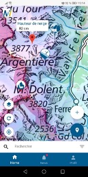
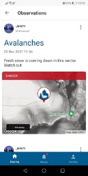
One key feature of MountaiNow is to allow for the easy capture and real-time sharing of critical hazard observations such as rock-falls, landslides, snow/ice avalanches, glacial lakes, and high river-discharge. Observations of hazard precursor signs such as glacier melt or fractured snow-pack are also included.
Benefits are multi-dimensional: Social – Saved lives and less accidents or situations of distress; Economic – higher number of clients for tourism services; and Environmental/Scientific – advanced monitoring of mountain areas and related hazards (e.g. landslides, glacial lake outbursts).
Learn more about the service: www.mountainow.net
Learn more about e-shape: www.e-shape.eu
A question? Contact the Helpdesk: https://helpdesk.e-shape.eu
This page has no comments.