| Content Column |
|---|
| tabbed-blocks | true |
|---|
| width | 100.0% |
|---|
| id | 2047532052 |
|---|
|
| Content Block |
|---|
|
MoutainNow is an international crowdsourcing platform for sharing mountain observations in real-time. Designed for use by the public, MountaiNow offers a live map of the latest mountain conditions and hazards (e.g. crevasses, rock falls) – to improve mountain safety and better adapt to climate change. The App is live on the appstores and web at www.mountainow.net | Sponsor | Project | Solution provider | User |
|---|
| | | |
|
| Content Block |
|---|
| name | Taxonomy |
|---|
| id | 2119719941 |
|---|
| Emergency Meteo Travel & Tourism Emergency Services climate Citizen and Society Smart CitiesLocal & Regional planning |
| Content Block |
|---|
| name | User profile |
|---|
| id | 2047532054 |
|---|
| - Mountain enthusiasts/groups (individuals, friends and families who enjoy mountains e.g. Alpine Clubs and associations) - Environmental services (e.g. national parks, public/private environmental offices, safety & accident prevention institutions) Examples: - Members of the Swiss Alpine Club (150,000 members) - Gran Paradiso National Park, Italy (park management authorities)  Image Removed Image Removed  Image Removed Image Removed
The Italian Civil Protection Department carries out tasks of guidance, promotion and coordination of the entire National Service of Civil Protection. In close collaboration with Regions and Autonomous Provinces, drafts and coordinates the National Plans for risk scenarios and test their effectiveness through drills, coordinates the Service's intervention in case of emergencies of national interest, promotes activities aimed at prevision and prevention of risks, defines the general criteria for the identification of seismic zones and develops general guidelines for training activities in the field of civil protection.
The Department also coordinates the participation of the National Service to the civil protection policies of the European Union and the response to emergencies abroad.
 Image Added Image Added
|
| Content Block |
|---|
| name | Service description |
|---|
| id | 2047532055 |
|---|
| CIMA Foundation hydro-meteorological forecasting chain, including the cloud-resolving WRF model assimilating radar data and in situ weather stations (WRF-3DVAR), the fully distributed hydrological model Continuum (assimilating Sentinel 1 soil moisture data, the automatic system for water detection (AUTOWADE), using Sentinel 1 data, and the hydraulic model TELEMAC-2D, has been operated in real-time to predict the weather evolution and the corresponding hydrological and hydraulic impacts of the medicane Apollo, in support of the Italian Civil Protection Department early warning activities.
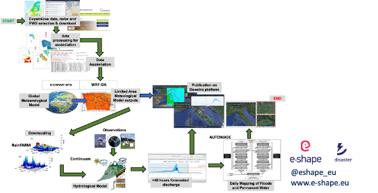 Image Added Image Added
Next-Generation Mountain Equipment. This is what MountaiNow is about. A live map combining community observations with satellite data - to keep you safe and help you make the most of your hiking, climbing, and ski touring adventures. Join us now ! www.mountainow.net  Image Removed Image Removed
|
| Content Block |
|---|
| name | Customer experience |
|---|
| id | 2047532056 |
|---|
|
“Meets a real need. Unique App” Bruno, user, on Google Play. « Simple and fast. Just the tool the mountain community needs to share on safety. I strongly recommend it!” Jean-Christophe, user, on Google Play “The possibility to transmit in real-time localised hazards to the community of mountaineers is truly unique and of major importance. This is why we have established a key partnership with MountaiNow to foster crowd-sourcing and participate in its future development” Jean Micol, President Swiss Alpine Club, Diablerets. “We have actively participated, from the beginning, in the testing of MountaiNow. MountaiNow is an innovative app which, exploiting technology, exponentially increases the knowledge of conditions as well as the safety of users” Stefano Cerise, Chief Inspector, Surveillance Corps, Gran Paradiso National ParkThe Italian Civil Protection confirmed its interest in results like the one provided for the Apollo Medicane (24-31 October 2021). This is confirmed also by the presentation of the results at the HSAF User Workshop 2022, hosted by ZAMG and supported by EUMeTrain, where Italian Civil Protection Department (Dr. Silvia Puca) has a key role.
|
| Content Block |
|---|
|
Climate change is changing mountains, creating new needs for safety and adaptation. MountaiNow – a live map of mountain hazards for the Alps and the world – was created to meet those needs. Highly innovative is the combination of real-time in-situ crowdsourcing, space insight, and guided navigation – offering a new/unique set of actionable informationHaving access to substantial high performance computing capabilities and storage capabilities for the execution of the complex hydro-meteorological workflow. |
| Content Block |
|---|
| name | Challenges |
|---|
| id | 2047532059 |
|---|
|
Timely geo-localized information about mountain hazards is still hard to get. Most of the time, people go to the mountains missing critical information. Public/Private actors make decisions missing critical data – impacting thousands of lives and costing the outdoor/tourism/insurance industry millions. One key feature of MountaiNow is to allow for the easy capture and real-time sharing of critical hazard observations such as rock-falls, landslides, snow/ice avalanches, glacial lakes, and high river-discharge. Observations of hazard precursor signs such as glacier melt or fractured snow-pack are also includedCost of computing services. For sake of clarity the services is only meant for civil protection purposes and on demand, urgent computing mode. |
| Content Block |
|---|
| The WRF-3DVAR model (available 330UTC, Oct. 24th, 2021) showed very good predictive capability concerning the timing and the location of most intense rainfall phenomena over Catania and Siracusa provinces in Sicily, thus enabling also very accurate discharge peaks and timing predictions for the creeks hydrological network peculiar of eastern Sicily Based on the WRF-3DVAR model predictions, the daily run of the AUTOWADE tool, using Sentinel-1 (S1) data, was anticipated with respect to the schedule to quickly produce a flood map (S1 acquisition performed on Oct. 25th, 2021, at 5.00 UTC, flood map produced on the same day at 13.00 UTC). Moreover, considering that no S1 images of eastern Sicily were available during the period Oct. 26-30, 2021, an ad hoc tasking of the COSMO-SkyMed satellite constellation was performed, again based on the on the WRF-3DVAR predictions, to overcome the S1 data latency The resulting automated operational mapping of floods and inland waters was integrated with the subsequent execution of the hydraulic model TELEMAC-2D Benefits are multi-dimensional: Social – Saved lives and less accidents or situations of distress; Economic – higher number of clients for tourism services; and Environmental/Scientific – advanced monitoring of mountain areas and related hazards (e.g. landslides, glacial lake outbursts).  Image Removed Image Removed  Image Removed Image Removed |
| Content Block |
|---|
| name | References |
|---|
| id | 2047532061 |
|---|
| Learn more about the service: www.mountainow.net We tested the service for selected case studies, in particular Apollo medicane. The results will be available in consolidated form over the MyDewetra platform, solely for research purposes, before the final review meeting of E-SHAPE project Learn more about e-shape: www.e-shape.eu A question? Contact the Helpdesk: https://helpdesk.e-shape.eu
|
|
|