![]()
UAV ASIGN is a novel approach for UAV's to make relevant full resolution imagery available with a minimum use of bandwidth, providing visual situational awareness in a new way with focus on the relevant information.
ASIGN is an advanced global image & sensor communication system for situational awareness. The innovation of the ASIGN solution lies in technology that allows focusing on content for relevance of the operations. Relevance can only be decided by the situation, by the viewers, and by the time information is received. Focusing on management of maximum relevant information instead of traditional compression offers a potential of 100 to 1000 times increase in performance. The key of the UAV ASIGN innovation lies in the two-step, interactive and adaptive push-pull concept. Preview photos are send to a central server whereafter authorised users can select Regions of Interest (ROI) for which they can request transfer of more details in higher quality. With this approach, data transfer requirements are reduced 200-300 times over sending full-size images. Video clips are handled in a similar two-step approach. First, a still-image 'storyboard' preview is send. Users can select video segments in the resolution quality and frame-rate needed. A storyboard is typically 1000 times smaller than one minute of HD video.
A recent study of ESA showed that the costs of satellite data transfer far outweighted the costs of the UAV flight operations for oil and gas pipeline monitoring, where high resolution photos and live optical and thermo video is required. The implementation of how photo and video transfer can hence make or break the business case for UAV surveillance and monitoring.
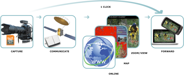
ASIGN overview seen from the user point of view
As it turns out, the major element in the operating costs of UA-bases visual monitoring, like for pipelines, is the cost of the real-‐time video transfer. Hence, the way the video transfer is managed can make or break the overall business case for oil-pipeline monitoring with UAV's.
Real-time visual situational awareness, using photo and video, where relevant information can be seen is essential. Knowing 'what, where and when' something essential happens, as it happens, will help decisions that could ultimately have a large impact e.g. on the ability to save lives, to protect critical infrastructure, environment or society. A live connection for photo/video/sound is important for several reasons, including operational, for real-time situational view, safety and control, risk reduction, remote inspection and data quality monitoring.
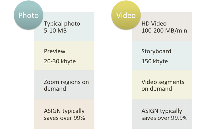
Examples of experienced saving in capacity for photos and video clips
An innovative compression technology in combination with a two-step, interactive and adaptive push-pull concept is the basic concept behind the ASIGN technology.
With focus on visual communications, ASIGN is not only the traditional optimization for better images at a given bit-rate, but rather than using the traditional approaches we allow the users to define regions, sections or segments of photos, video, images (when the transitions occur is a matter of definition), so a photo can consist of an overview in basic quality with patches (like a face or a license plate) in higher, up to full, original, quality. With video, not every minute or every region may be of equal importance, and paying for every byte when transferred over satellite (or any network with limited capacity), it does not make sense to spend as much resources for less interesting or relevant segments as it does for more relevant.
For UAV's operating in local radio range, video and photos are downlinked via Wi-Fi to the ground controller unit. It is then relayed via satellite or mobile networks to remote online destinations for viewing in real-time. If mobile networks are available, images are sent to a server via a GSM/3G/4G modem, and relayed back tot he field for local monitoring in real-time. In case there is no terrestrial coverage, Satcom is used (Inmarsat Aero Terminal, SB200).
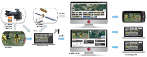
ASIGN overview for PC based version, showing also server view and receivers.
ASIGN is tackling the challenge of low bandwidth and high data cost transfer of satellite communication.
Visual data transfer can when used in a traditional manner require more communications capacity than available when most needed, such as during disasters, operations at sea and from air. Mobile satellite systems at L-‐band, like BGAN, provide global coverage anytime, but have fairly limited bandwidth shared between many users, and potentially high use cost. ASIGN offers solutions that are needed for reducing operational cost and increasing speed of transfer for visual communications over MSS networks. Accurate geo-referencing and time stamping of the sent data is included.
General characteristics:
- Visual: State of the art digital photography (video, sound)
- Position: Embedded GPS coordinates for direct mapping
- Sensor Networks: Embedded sensors as required
- Freedom: Radio (WiFi) access to local computer
- Reliability: Satellite (BGAN) or GSM/GPRS to remote server
- Integration: Mapping and advanced processing
- Affordable: Cost effective communications
- Suitable for surveillance, monitoring, rescue, intelligence and more
- Complements Remote Sensing perfectly.
Key technical features:
- Audio, 2-‐way, for Air Traffic Control
- Infrared Video real time transfer
- Optical Video real time transfer
- Hi resolution still photos, pseudo-‐real-‐time transfer
- Sensor data transfer from other UA sensors.
- Data Geo-‐tagging via on-‐board GPS
- SB200 Traffic Management taking into consideration the very low data rates
- On-‐board computer integration and peripheral interfacing with HW drivers
- Ground Web Communications Server integration
- Ground server Live Audio and View Video
- Remote Live View for pilot
- Remote Live Audio for pilot
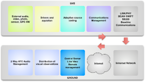
Basic overview of UAS and ground elements
This page has no comments.