Surveying a basalt plain in Argentina The Neuquen Basin in Argentina includes basalt flows from several volcanoes. Repsol YPF commissioned a seismic acquisition for the basin The area of interest has a large plateau covered by flood basalt, along with isolated lava flows. The underlying clastic sediments and volcanic tuffs are substantially softer than the basalt, so the slopes of the plateau are steep, presenting a risk of rollover for vibrators and other vehicles. This risk was mapped using a DEM, which showed the steep slopes dropping from the plateau into adjacent valleys.
The solidified lava flows form a rough terrain that confines vehicular movement to the space between the basalt flows. In addition, large basalt blocks on the plateau have the potential to completely block vehicular access to some areas. The objective for the remote sensing study was to identify and map the risks for rollover and access restriction.
In desert areas, such as in the Egyptian desert case discussed above, vegetation is absent, but in this area of Argentina, the presence of various bushes and grasses required spectral bands that can discriminate the vegetal type. Photos from a ground survey indicated the locations with the basalt blocks had brush up to half a meter tall, whereas locations covered by fine basalt gravel had a thin layer of grass. Of course, the resolution of the satellite images is much coarser than such features so they could not be distinguished by individual shapes. However, the thermal (TIR) band is sensitive to basalt and insensitive to vegetation. The boulder-covered areas are clear in the image including this band.
The boulders also pose a point-loading risk for the vibrator pads. The large rocks would provide poor coupling of the seismic energy to the ground. In addition, the combination of volcanic rocks, vegetation and steep slopes increases the risk for the vibrator baseplate to slide during acquisition. Sliding increases distortion.
The northern and western parts of the plateau are covered with gravel, which will produce overall good quality seismic data. However, the central basalt-covered plateau presents both logistic and data-distortion risks.
Based on the assessment that much of the survey was inaccessible to line vehicles, portable recording equipment was delivered to the site via helicopter to avoid carrying it over long distances. In addition, using the DEM, the survey designers adjusted the location of the vibrator source lines to account for the complex terrain on the slopes.
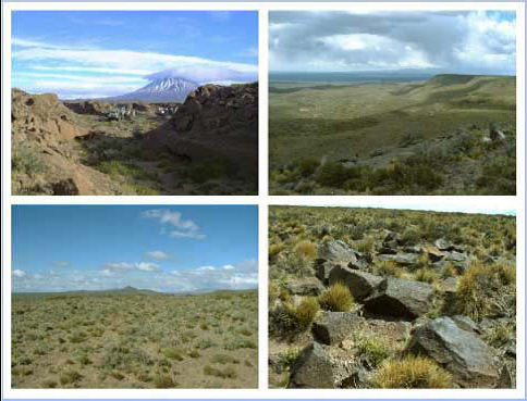
Study area in Argentina. The basalt plateaus with lava flows (foreground) originated from volcanoes in the area, one of which is in the background (upper left). The escarpment is partly covered by grass (upper right). The northeast of the study area is a gravel plain (lower left), and the central area is covered by large blocks of basalt and bushes (lower right).
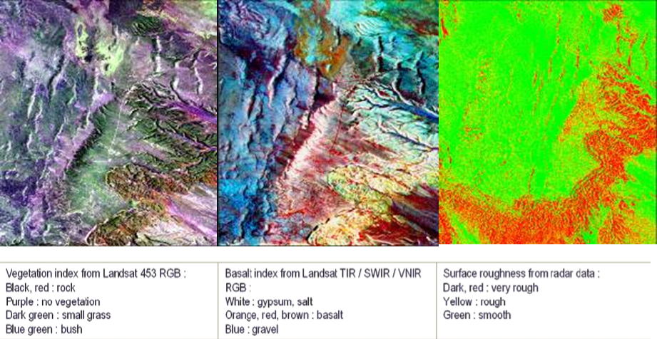
Landsat 7 remote imaging of a basalt flow. The 453 RGB image of this area separates small grass and bush from exposed rock (left). Mixed colors occur when two features are present, such as grass loosely covering basalt rocks giving a combination of red and dark green. A different combination of bands is TIR/SWIR/VNIR 654 RGB (AL : correct) discriminates basalt from gravel, gypsum or salt (middle). The radar image (right) indicates the surface roughness, ranging from very rough escarpments (red) to smooth plains (green).
The Neuquen Basin in Argentina includes basalt flows from several volcanoes. Repsol YPF commissioned a seismic acquisition for the basin The area of interest has a large plateau covered by flood basalt, along with isolated lava flows. The underlying clastic sediments and volcanic tuffs are substantially softer than the basalt, so the slopes of the plateau are steep, presenting a risk of rollover for vibrators and other vehicles. This risk was mapped using a DEM, which showed the steep slopes dropping from the plateau into adjacent valleys.
The solidified lava flows form a rough terrain that confines vehicular movement to the space between the basalt flows. In addition, large basalt blocks on the plateau have the potential to completely block vehicular access to some areas. The objective for the remote sensing study was to identify and map the risks for rollover and access restriction.
In desert areas, such as in the Egyptian desert case discussed above, vegetation is absent, but in this area of Argentina, the presence of various bushes and grasses required spectral bands that can discriminate the vegetal type. Photos from a ground survey indicated the locations with the basalt blocks had brush up to half a meter tall, whereas locations covered by fine basalt gravel had a thin layer of grass. Of course, the resolution of the satellite images is much coarser than such features so they could not be distinguished by individual shapes. However, the thermal (TIR) band is sensitive to basalt and insensitive to vegetation. The boulder-covered areas are clear in the image including this band.
The boulders also pose a point-loading risk for the vibrator pads. The large rocks would provide poor coupling of the seismic energy to the ground. In addition, the combination of volcanic rocks, vegetation and steep slopes increases the risk for the vibrator baseplate to slide during acquisition. Sliding increases distortion.
The northern and western parts of the plateau are covered with gravel, which will produce overall good quality seismic data. However, the central basalt-covered plateau presents both logistic and data-distortion risks.
Based on the assessment that much of the survey was inaccessible to line vehicles, portable recording equipment was delivered to the site via helicopter to avoid carrying it over long distances. In addition, using the DEM, the survey designers adjusted the location of the vibrator source lines to account for the complex terrain on the slopes.
Study area in Argentina. The basalt plateaus with lava flows (foreground) originated from volcanoes in the area, one of which is in the background (upper left). The escarpment is partly covered by grass (upper right). The northeast of the study area is a gravel plain (lower left), and the central area is covered by large blocks of basalt and bushes (lower right).
Landsat 7 remote imaging of a basalt flow. The 453 RGB image of this area separates small grass and bush from exposed rock (left). Mixed colors occur when two features are present, such as grass loosely covering basalt rocks giving a combination of red and dark green. A different combination of bands is TIR/SWIR/VNIR 654 RGB (AL : correct) discriminates basalt from gravel, gypsum or salt (middle). The radar image (right) indicates the surface roughness, ranging from very rough escarpments (red) to smooth plains (green).
This page has no comments.