From 2004 to 2013 BP, Sonatrach and Statoil used CO2 storage techniques in Krechba (Algeria) for the In Salah project, moving carbon dioxide from the close-by gas field and storing it underground to permanently remove it from the atmosphere. Starting in 2011 TRE (Tele Rilevamento Europa) used historically acquired SAR imagery and on-going InSar surface deformation monitoring to understand the movement of CO2 in the subsurface. The analysis of newly acquired and stored EO data let construct maps of ground deformation, which highlight uplift related with the gas injection.
The geological storage of carbon dioxide (CO2) involves collecting and injecting carbon dioxide underground in order to permanently remove it from the atmosphere. One such example is the In Salah project, located in Krechba in Algeria and operated by BP, Sonatrach and Statoil, where CO2 was extracted from the adjacent producing gas field and stored in the aquifer at a depth of 1.8 km.
Past experience with the use of CO2 for secondary oil recovery suggested that the migration of CO2 within the Earth can be complicated, and can differ from the movement of injected water or the flow of hydrocarbons. Due to the complexity of the movement of CO2 in the subsurface, and the desire to keep it from migrating back up to the surface, there was a need to monitor the fate of the injected CO2 with EO data.
Techniques measuring surface deformation provide a basis for cost-effective, long-term reservoir monitoring for subsidence and uplift. EO imagery (in this case SAR imagery) was remotely acquired over the area of interest and processed periodically to provide maps of ground movement.
On-going InSAR surface deformation monitoring was applied over In Salah throughout the period of injection to monitor potential ground movement associated with gas storage and determine possible associated complications. Injection started in 2004 and was suspended in 2013. For the period prior to active monitoring (from 2011 onwards), historically acquired SAR imagery was processed to determine past surface movements.
A combination of historical satellite data and tasked monitoring satellites were used to determine ground movement over the injection period. The historical data were acquired by the Envisat satellite from 2003 to 2010 and Cosmo-SkyMed and TerraSAR-X imagery were actively tasked to acquire throughout the latter injection period of 2011-2013, in both ascending and descending geometries.
The SAR imagery was regularly processed to provide updates on: the status of ground movement, the location of the CO2 plume, well integrity and pressure development over time.
Resultant maps of ground deformation were used to determine both vertical and horizontal surface movement through time. The InSAR results were inverted to the injection horizon by Lawrence Berkley National Labs (LBNL) to determine the characteristics of potential fault/fracture opening at depth related to gas volume injection
The results highlighted uplift concerned with the injection of gas at the well locations. Uplift was correlated to the injection profiles and produced localised uplift patterns around the wells. Figure 1 shows the results of the Envisat processing from 2004 – 2008. The uplift patterns observed over the three injectors were in the range of 2cm, significantly more than had been previously predicted.
Over well KB-502 an uplift pattern similar to a double-lobe was identified, with an associated symmetric horizontal movement pattern. The uplift was later identified by inverse modelling at LBNL to a fault/fracture opening of 35cm at depth. The fault/fracture was thought to be vertical (or dip at a very high angle) and to lie between the two lobes of range decrease, trending to the northwest.
The exact vertical extent of the fault/fracture was not well constrained but it did intersect the reservoir interval. It is worth noting that rather than the opening of a single fault, the model could correspond to a damage zone, where a complex network of smaller fractures could be the actual source of strain. The orientation of the estimated fault plane is northwest/southeast, in agreement with the direction of the regional fault system and the maximum horizontal stress. The existence of such a fault/fracture was supported by seismic data and by logging information.
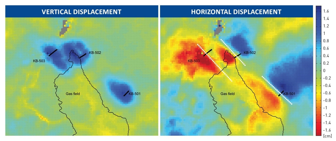
Figure 1: (Left) Vertical displacement [in cm] between 2004 July and 2008 May from Envisat data: upward motion is positive (blue) and downward motion, or subsidence, is negative (red). The thick black lines indicate the extent of each of the three horizontal wells (KB-501, KB-502 and KB-503) within the reservoir. The approximate location of the gas field is indicated by the thin black curve. (Right) Horizontal displacement for the same time period: eastward motion is positive (blue) whereas motion to the west is negative (red).
The study illustrates that EO observations can be used to monitor the fate of CO2 injected deep within underground reservoirs. Through a combination of processing historical SAR imagery and tasked monitoring satellites, the continuous monitoring of surface deformation could be used to determine the migration of gas and pressure development within the aquifer and monitor the integrity of wells.
Over the course of the project, an injected mass of 3 million tonnes of CO2 gave rise to surface deformation of a few millimetres per year. Detailed images of this surface deformation, provided by InSAR data, suggested preferential flow away from the injection wells and the opening of a tensile feature at depth. The tensile feature coincides with a seismically imaged fault intersecting the reservoir. The preliminary results indicated that, when an accurate elastic Earth model is used, it is possible to fit the observations with volume and aperture changes that are essentially at the reservoir level.
Contact Information: TRE
Vasco, D.W. & Ferretti, A., [2005] On the use of quasi-static deformation to understand reservoir fluid flow, Geophysics, 70, O13–O27.
Ringrose, P., Atbi, M., Mason, D., Espinassous, M., Myhrer, Ø., Iding, M., Mathieson, A. and Wright, I. [2009]. Plume development around well KB-502 at the In Salah CO2 storage site. First Break, 27(1), 85-89.
Raikes, S., Mathieson, A. and Roberts, D. [2008] Integration of 3D seismic with satellite imagery at In Salah CO2 Sequestration Project, Algeria. 78th SEG Annual Meeting, Expanded Abstracts, 27, 2856-2858.
Vasco, D.W. , Ferretti, A. and Novali, F. [2008] Estimating permeability from quasi-static deformation: temporal variations and arrival-time inversion. Geophysics, 73, 37–52.
Rucci, A., Vasco, D.W. & Novali, F., [2010] Fluid pressure arrival-time tomography: estimation and assessment in the presence of inequality constraints with an application to production at the Krechba field, Algeria, Geophysics, 75, O39–O55.
Vasco, D.W., Rucci, A., Ferretti, A., Novali, F., Bissell, R., Ringrose, P., Mathieson, A. & Wright, I., [2010] Satellite-based measurements of surface deformation reveal fluid flow associated with the geological storage of carbon dioxide, Geophys. Res. Lett., 37, 1–5.
Rucci, A., Vasco, D.W., Novali, F. [2013] Monitoring the geologic storage of carbon dioxide using multicomponent SAR interferometry, Geophys. J. Int.
Ferretti, A., Prati, C. and Rocca, F. [2001] Permanent Scatterers in SAR interferometry, IEEE Transactions on Geoscience and Remote Sensing, 39, 8-20.
Ferretti, A. [2014] Satellite InSAR Data: Reservoir Monitoring from Space, EAGE.
This page has no comments.