Success Story on the use of EO to study piracy
The GlobWave project aimed to improve the uptake of satellite-derived wind-wave and swell data by the scientific, operational and commercial user communities. The project, which run from January 2009 – December 2012, covered the development of an integrated set of information services based on satellite wave data, and the operation and maintenance of these services for a demonstration period.
These activities are intended to make it easier for the global user community to use satellite wave data, to facilitate routine comparison with wave models and to stimulate the development of satellite wave data assimilation.
A study carried out by the New Zealand Defence Force (NZDF) shows how GlobWave data has been successfully used to examine the climatic factors affecting piracy in the Indian Ocean.
Project Background
The GlobWave Project is an initiative funded by the European Space Agency (ESA) and subsidised by CNES through the Data User Element (DUE), which is a programmatic element of the 3rd period of the Earth Observation Envelope Programme (EOEP-3), an optional ESA programme.
It has been led by Logica, with key expertise provided from Satellite Oceanographic Consultants Ltd (SatOC), Collecte Localisation Satellites (CLS), Ifremer and National Oceanography Centre (NOC). It
Issues & Needs
Piracy may be a topic of schoolboy adventure stories, but it’s still a dangerous and costly problem for merchant shipping and tourism in some parts of the world. In the pirate-ridden waters of the Indian Ocean, satellites show that environmental conditions have limited recent pirate activity. The picture below shows the mean daily wind speed at Socotra (Yemen) and pirate attacks by latitude for April 2010 to July 2011.
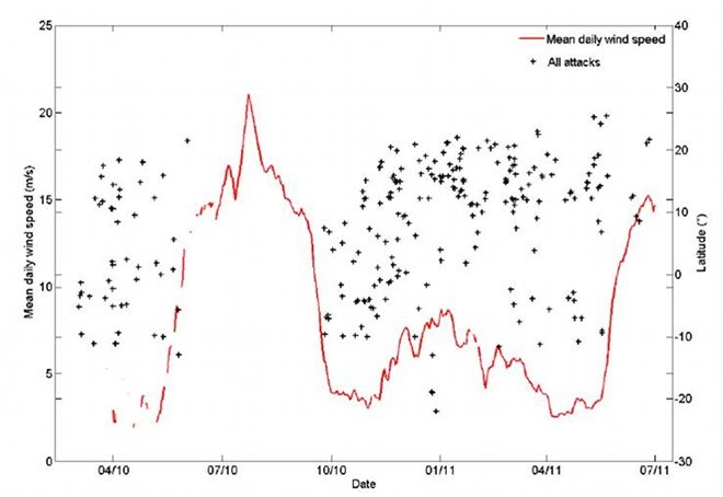
Mean daily wind speed at Socotra (Yemen) and pirate attacks by latitude for April 2010 to July 2011. When the wind speed dropped, pirate attacks increased
Nearly half of all recorded maritime piracy worldwide in 2010 has been attributed to Somali pirates, with a cost to the international community of over USD $8bn a year. And that’s just the financial impact; some 62 deaths and many more injuries of over 3500 captives in the last four years have been due to Somali pirates.
Unfortunately, these figures only tell part of the whole story of recent maritime piracy. For a myriad of political and commercial reasons, piracy is often downplayed and underestimated by both governments and industry. The International Maritime Bureau (IMB), for example, estimates that as many as half of all pirate attacks go unreported. Attacks and hijackings of ships by Somali pirates in waters off the Horn of Africa have sharply increased in recent years, and show no sign of waning.
But while the number of attacks per year continues to increase, 2011 saw a 40% drop in ‘successful’ attacks – or hijackings – compared to the previous year. The drop in successful attacks could be due to a number of factors such as increased security – but satellites show that climate is also controlling piracy
Solution
The New Zealand Defence Force (NZDF) has used information from ESA’s GlobWave project, to examine in detail the climatic and oceanographic conditions that accompanied attacks by pirates in the Horn of Africa region between 2010 and 2011.
Considering the problems collecting direct observations of marine weather in recent years, a valuable alternative for oceanographic data east of Somalia are observations collected by satellites. They used observations of significant wave height and wind speed from the European Space Agency GlobWave project databases.
These databases provided quality controlled satellite altimeter measurements from the Envisat, Jason1 and Jason2 satellites. Observations that were measured within six hours and 1000 km of a singular pirate attack were selected for this study. If more than one observation met these criteria, the satellite with the closest spatial observation was used.
Results & Perspectives
The study found that there was a strong correlation between successful pirate activity and wind speed and wave height. The summer monsoon season from June to September, when weather conditions are usually bad, saw a significant drop in pirate activities. This correlation is probably due to the difficulty of launching pirate boats from beaches when the waves are high.
The GlobWave databases provided observations of significant wave height (SWH) and surface wind speed for 54% of all pirate attacks. Wind speeds during pirate attacks were mainly low (less than 11 m.s-1) but once wind speeds exceeded 9 m.s-1, no successful attacks occurred (Fig a). Their satellite-derived record showed only one instance where pirates attacked in winds speeds greater than 11 m s-1. Nearly all piracy was in seas with SWHs <2.5 m (97% of paired observations) (Fig b), and most attacks were conducted in calm oceans with waves <1 m height. No successful attacks occurred on days where SWH exceeded 2.5 m. Four events, representing 3% of the satellite observations, were recorded with SWH >2.5 m. These attacks all happened in June 2011.
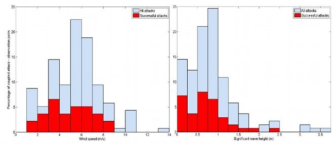
Satellite observations of wind speed (a) and significant wave height (b) for pirate attacks off Somalia, 2010–2011
Related Info
This study was undertaken by Duncan Cook and Sally Garret from the NZDF and Martin Rutherford from the Royal Australian Navy and was presented in December 2011 at the International Congress of Biometeorology in Auckland, New Zealand. Further information and a link to the paper can be found on the GlobWave portal
This page has no comments.