GMV was able to detect a 7m long ship with immigrants that was on risky conditions at sea by processing a SAR image. GMV executed the exercise in support of an operational Search & Rescue (S&R) mission that implied the coordination of some surveillance means (aircrafts and patrolling ships). Thanks to the detection report, the surveillance means were able to locate the target quicker than if they would have surveyed the complete searching area. The implications of this result in operational ship monitoring are large because they would imply to review the procedures to add satellite imagery as an essential add-on.
The campaign was initially conceived as a blind experiment where an in-situ ship shall be located within an area that would be covered by a scheduled SAR image. No a priori information about the true location of the ship was available, except that the ship course was synchronized within the satellite overpass. The data was planned to be acquired at 16-09-2014T1812 and the order was sent at 15-09-2014. At 16-09-2014T1200, the ship involved in the experiment received a Search and Rescue call for looking and rescuing 38 in-distress immigrants on-board a rubber 7 m long boat with the engines out of order. The operational search zone covered approximately 50.000 km2 and included the area of the test site. Thus, GMV and Frontex decided to use the scheduled image to support the S&R mission.
Image© abc
The scheduled image, a RADARSAT2 Ultra-Fine image with 3 m of resolution, was processed in less than 3 h from the acquisition time by the GMV operational chain SIMONS. The ship detection report pointed out the presence of a potential target of interest cruising to the North. The report was immediately passed to Frontex, who passed away to the Spanish Authorities. The coordinates of the detection were used to delimitate the search zone and this permitted the location of the boat on the morning of 17.09 14,5 NM far away from the position reported by the satellite image. All the people were safely rescued.
- News EL PAÏS
- SAGRES reported the first success case that has permitted the location of a ship with human beings on-board, which became lost due to an engine failure, 2014-09
FP7 project SAGRES and use of satellite images successfully contributed to rescue persons in distress at sea on 17.09.2014. Thanks to the analysis processed on the satellite image taken on 16.09.2014 evening a small boat was detected at high seas with migrants in distress.
SAGRES project supports the pre-operational test and deployment of the high-time critical, intelligence driven maritime surveillance component via the EUROSUR network.
This particular activation (as one of the last activations within the project) was planned in advance with cooperation with Frontex, defining a limited area within the Mediterranean Sea for a limited period of time: 16-09-2014 evening. The activation defined a set of exercises with the aim to further tests the capability of Earth Observation (EO) imagery to support maritime surveillance within specific operational environments.
The challenging trial was organized with the cooperation of Spanish authorities where it was planned to involve a patrolling vessel in the West Mediterranean Sea. The goal was to detect a small target (non-metallic target with a length < 10 m) by combining the processing of EO images with cooperative reporting streams.
However, on 16.09.2014 afternoon an urgent call to search for a boat with migrants was received and the asset was forced to join the mission.
Luckily, the operational search zone was not far away from the area designed for the trial. Thus, SAGRES and Frontex decided to use the ordered image, a Synthetic Aperture Radar image acquired by the RADARSAT2 satellite sensor in Ultra Fine mode with 3 m of resolution, to support the mission.
The image was processed in less than 3 h from the acquisition time. The ship detection report pointed out the presence of a potential target of interest cruising to the North. The report was immediately passed to Frontex, who passed away to the Spanish Authorities. The coordinates of the detection were used to delimitate the search zone and this permitted the location of the boat on the morning of 17.09 14,5 NM far away from the position reported by the satellite image.
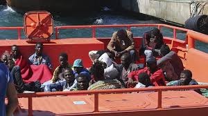
Thanks to the rapid intervention of the Spanish authorities, the 38 migrants (including 8 women and 3 babies) on-board were rescued and saved their lives.
The contribution of SAGRES has been essential as the EO-based ship detection permitted reducing the initial huge area and this eased the search mission. This success case shows how EO technology can support high time critical maritime surveillance and how this technology can be used to save lives at sea.
This page has no comments.