Success Story on the use of EO to monitor critical infrastructure
e-GEOS, an ASI/ Telespazio company, has developed an advanced persistent scatterer interferometry approach, named Persistent Scatterer Pairs (PSP) – IFSAR, an original solution to the main limitations of classical techniques in the accurate determination of terrain displacement. The e-GEOS PSPIFSAR high-performance processing chain provides PS measurements over large areas.
The project is a collaboration of e-GEOS and JSC NIIAS on behalf of JSC RZD. It started with COSMO-SkyMed based Monitoring service over Tuapse-Adler railway line between December 2008 and May 2014. Operational services were provided on monthly basis which brought to the detection of known and new deformations within areas adjucent to the railway.
The e-GEOS Advanced technologies can significantly contribute to the quality of control and supervision of the hard terrain on which Russian railways grow, moreover, in the nearest future, Russia is planning to build a number of high-speed lines to connect Moscow with Kazan, Yekaterinburg and Nizhny Novgorod. Those are cities with multi-million populations surrounded by densely populated small towns and communities. The adjacent territories have well-developed motorway systems which calls for a operational approach to the passenger traffic safety. Another strategically important matter for the Russian Railways is the infrastructure development of the Baykal Amur and Transsiberian mainlines affected by various negative natural effects, namely related to cryogenic processes in permafrost areas.
e-GEOS provided the retrospective analysis of terrain displacement (PSP-IFSAR processing) granting the monthly monitoring of terrain anomalous behaviour, monitoring of terrain displacement based on the acquisition of a COSMO-SkyMed image over the area of interest updating of terrain displacement measurements starting from the previous analysis. E-GEOS provided the analysis of displacement information related to the acquired image, comparing with the expected displacement trend for the identification of possibly critical deformations. The processing of SAR imagery using the PSP method allowed generating highly accurate displacement maps with a large number of persistent scatterers and identification of their displacement in time. SAR interferometry has shown its efficiency as a component of a comprehensive geotechnical monitoring that complements the conventional on-site inspections of infrastructure facilities with Earth remote sensing of adjacent territories.
STEP1- Analysis of terrain displacement
Collection of a COSMO-SkyMed dataset over the area of interest, acquired according to site topographic characteristics, within a reference period
Processing and analysis of the dataset to produce terrain displacement measurements over the AOI during the reference period (displacement mean velocity and temporal evolution)
PRODUCT VALUE
Identify areas affected by potentially hazardous geodynamic processes
Having a reference information for further monitoring activity
STEP2- Monitoring of terrain displacement
Acquisition of a COSMO-SkyMed image over the area of interest
Updating of terrain displacement measurements starting from the previous analysis
Analysis of displacement information related to the acquired image, comparing with the expected displacement trend for the identification of possible critical deformations (activation of effects).
PRODUCT VALUE
Updating of displacement measurement at the present date
Identify areas subject to anomalous trend displacement at the present date
Having a reference information for next monitoring activity
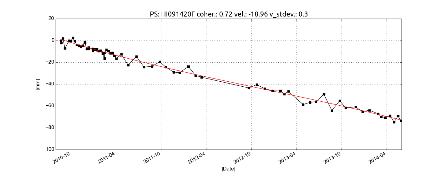
Figure. The temporal evolutions (black lines) and the corresponding second degree polynomial regressions (red lines) for a point on the ground located in the Southern exit of the railway tunnel in the Mamayka area. The analysis covers the period August 2010 - May 2014
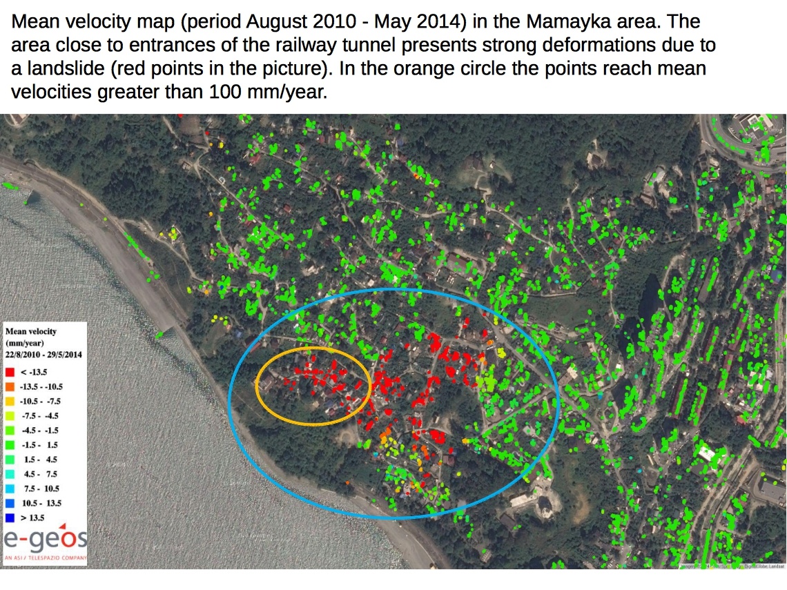
The validation activity verified, through COSMO-SkyMed persistent scatterer interferometry approach, Persistent Scatterer Pairs (PSP) – IFSAR PSP-IFSAR analysis (August 2010- March 2012) that highlights relevant terrain displacement occurred
On-site inspections and precision geodetic measurements (in 2012) confirmed the development of landslide processes in several dozen identified areas within the investigated territory. Processes in several areas adjacent to the railway line, including the one near the Mamayka Landslide, may pose a threat to the railway infrastructure.
Project results were accepted by Final User, the North Caucasus Railway. The acquired information was used in the improvement of infrastructure protection facilities along the Tuapse – Adler line as part of the preparation for the Sochi 2014 Olympic Games.
COSMO-SkyMed based displacement measurement values were qualitatively confirmed in 2012 by dedicated in-situ precision geodetic measurements of terrain displacement.
Methods for interferometric measurements interpretation have been consolidated.
Project results were awarded the Golden Metal of METROLEXPO 2012 exhibition for development of innovative methods of measurements for monitoring extended infrastructure facilities.
SAR interferometry and the PSP-IFSAR approach to Ground deformation monitoring Repeat-pass satellite synthetic aperture radar (SAR) interferometry (IFSAR) is a very effective technology for the measurement with subcentimeter precision of ground deformation due to subsidence, landslides, earthquakes and volcanic phenomena. The technology relies on the fact that the phase difference between two SAR images acquired at different times and with almost identical view angles is related to the topography and also to the changes in the observed scene on the different dates. The measurements are made over fixed points: objects on the ground with stable radar backscatter properties. These persistent scatterers (PS) are usually found in areas with light vegetation cover, and especially corresponding to structures – artificial or natural – such as buildings, rocks, etc. SAR interferometry can be used to efficiently monitor slow geodynamic processes in areas with relatively high building density where the applicability of other Earth remote sensing techniques is limited due to man-made landscape changes.
This page has no comments.