Subsidence can cause gas and water pipelines to break right where they enter houses. In the Netherlands, satellite data are used to monitor gas pipelines at affordable costs.
Satellite images show hot spots where ground movement is taking place. It thus allows a targeted replacement programme: the maintenance strategy has now become focused on areas of higher risk. Instead of replacing pipes and connections in a single district pipes serving individual houses or streets can be replaced.
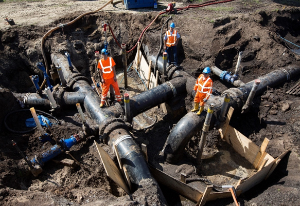
Ground subsidence is a particular problem in the area around Rotterdam. It can be so severe that soil levels can change by as much as 1m within a few years. This causes problems for underground pipelines making up the infrastructure of the area to deliver gas, water and steam to local citizens and businesses. The problem is most acute where pipelines cross over each other and where they connect to the consumers’ premises where a fracture risks a severe accident.
How to know where the risk lies? Older connections are more at risk than modern ones due to use of rigid metal rather than flexible plastic combined with the modern practise of installing a loop to absorb movement. Clearly the risk is greater where the ground is subsiding faster. In this case, the stress created on the household gas connection or on the water mains in the street can cause a failure with consequent leaks. In the case of water, this can cause severe disruption to traffic or, as we heard in one case, the flooding of a hospital basement; in the case of gas, the impact can be much worse if gas builds up in the space under a house when it may even explode.
The result is better investment of resources by the pipeline operators and less risk to consumers from gas leaks or disruption from major water leaks. Overall, we calculate an economic benefit coming from the use of this product by 2 infrastructure operators in the Netherlands to be €6.6- €7.9m per annum; extrapolated to all the operators over the whole country leads us to conclude a total potential benefit of €15.2m – €18.3m each and every year.
The report is available online.
This page has no comments.