Earth observation (EO) technologies are exceptionally useful in monitoring polar regions: EO can capture imagery over a broad geographic area as well as revisit the same areas at reliable intervals for frequent repeat captures.
The technology provides tools for operations in ice-prone waters: a large number of current satellites have the ability to map and characterise sea ice and icebergs. Satellite synthetic aperture radar (SAR) in particular is a natural fit for this task, as it can provide images day or night, through cloud or fog, and in various meteorological conditions. SAR data can be supplemented with low and high resolution electro-optical data to fill in gaps and aid interpretation.
SAR data alone can allow skilled interpreters to identify different types of ice and hence the risk that is posed to shipping or to off-shore operators such as drilling platforms. Knowing the environment and how it changes over a period of time, greatly increases the information available to engineers and designers of floating and fixed off-shore structures.
More than four decades of earth observation has accumulated a very significant archive of satellite data that can be used to assist characterisation of the ice environment. Since 1995 C-CORE has been analysing the value that EO technologies and derived data can bring to its oil and gas clients and has evolved a suite of EO-based services. With the industry’s increased focus on Arctic resources, C-CORE has seen a significant increase in uptake of these services, resulting in increased understanding of Arctic environments, increased confidence and reduced risk for clients operating in ice-prone waters.
Thorough understanding of the ice environment is needed to inform probabilistic design for Arctic offshore structures. Without knowledge of probable ice-structure interaction, designs must be overly conservative, requiring higher-than-necessary build costs to address the uncertainty associated with sea-ice and iceberg loads. Further, introducing ice management into operational planning lowers the risk of ice impact. When the resulting reduced impact risk is factored into design, additional concepts may be considered, which may also yield lower build costs. A critical component of an effective ice management plan is tactical (current) knowledge of the ice environment. Both tactical and historical knowledge of the ice environment can be achieved cost-effectively using EO satellite monitoring.
Satellite SAR mapping of ice has been available since the 1970s, although routine satellite SAR monitoring of ice has only been possible since 1992, with the launch of the European satellite ERS-1. This satellite also heralded an era of large-scale archiving of radar data. In addition to information available through various national ice centres, an archive of almost 20 years of raw SAR data can be used to create highly detailed historical maps of ice and icebergs to aid in the design process.
Many existing and almost all of the new SAR satellites are ‘operational’, in that they provide data in near-real-time, with imagery available via the internet within hours of acquisition. In the near term, the latest generation of SARs (scheduled for launch within the next few years) are specifying imagery delivery times of less than one hour; an investment in a ground station facility can allow data provision within minutes of acquisition.
With these capabilities, SAR can be used effectively by the oil and gas industry to facilitate Arctic resource development. The increasing prevalence of SAR, along with decreasing data costs and more flexible data policies, will lead to increased use of EO technologies and derived data by this sector into the future.
Over the last four years, C-CORE has conducted sea-ice and iceberg studies for clients in the Barents Sea, the Beaufort Sea, West Greenland, South Greenland, Baffin Bay, the Canadian Arctic Archipelago and the Falkland Islands. These studies have been conducted using archives and new acquisitions from RADARSAT-2, ENVISAT, Landsat, TerraSAR-X and Cosmo Skymed. These studies have been conducted in regions where little to no knowledge existed about sea ice and iceberg conditions. The availability of satellite data for these regions has provided a reliable, cost-effective alternative to the difficult and expensive gathering of equivalent information from ground or airborne-based sensors. Ice surveys using vessels and aircraft over extended periods can cost millions of dollars, while satellite studies cost one or two orders of magnitude less. Furthermore, satellite data archives provide ice information over long periods, yielding statistically relevant information. Confidence regarding ice conditions is increased, freeing E&P operators from the need to be overly conservative in structural design and operational resource planning. The cost savings realized using satellites facilitates accelerated exploration plans and improved structure design.
About C-CORE
C-CORE's mission is to be a world leader in the development and application of advanced engineering principles to solve operational challenges in the natural resource sectors and other target markets. Through responsiveness, excellence in service, continuously advancing technology, and understanding clients' needs, C-CORE will be the organization of choice for providing innovative services and products. C-CORE will conduct applied research and development with a motivated, highly qualified team working in a framework of sound business principles.
Contact: Desmod Power.
Captain Robert A. Bartlett Building, Morrissey Road, St. John's, NL, Canada A1B 3X5
T: 709-864-8354 / F: 709-864-4706 / e-mail: info@c-core.ca
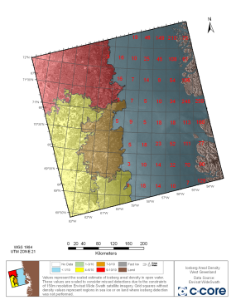
Figure1: Iceberg chart from West Greeland based on an ENVISAT ASAR Image. Analysis © C-CORE (2010).
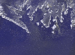
Figure2: RS2-10K is a RADARSAT-2 image containing over 10,000 icebergs in Melville Bay. Analysis © C-CORE (2011), RADARSAT-2 Data and Products © MDA (2011) – All Rights Reserved.
This page has no comments.