Surface deformation monitoring can provide valuable information about the dynamic behaviour of reservoirs under production.
Measuring these deformations can help to identify undepleted compartments, detect fault reactivation, mitigate risks associated with well failure, constrain geomechanical models, and aid field management decisions.
We have demonstrated that satellite InSAR is a powerful tool to measure surface movement and is useful for managing reservoirs under production.

SqueeSAR™ is the latest InSAR algorithm developed by TRE.
The InSAR analysis covers a stacked carbonate reservoir in the Middle East. The top reservoir is a mature gas with a depth of approximately 750 m, which is known to compact. The lowest reservoir is an oil reservoir with a 1200 m depth produced by a water-flood.
Both reservoirs are intersected by a major graben fault, trending NE-SW, as well as numerous additional extensional faults. Approximately 500 producer and injector wells have been drilled in the area.
A comparison with existing GPS measurements has shown a good agreement between InSAR and GPS data.
We have also inverted InSAR data using a geomechanical model to obtain reservoir strains. These compare well with pressure change maps from reservoir simulations. There is also an intriguing correlation between known fault systems at the reservoir level and the surface displacement data by satellite InSAR.
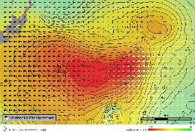
Figure 1 Ground surface response to hydrocarbon extraction. Red circles represent the surface coverage of extracting wells. Arrows indicate horizontal surface movement (East-West).
Surface deformation monitoring can provide valuable information about the dynamic behaviour of reservoirs under production.
Measuring these deformations can help to identify undepleted compartments, detect fault reactivation, mitigate risks associated with well failure, constrain geomechanical models, and aid field management decisions.
We have demonstrated that satellite InSAR is a powerful tool to measure surface movement and is useful for managing a reservoir under production.
Consistently updated information about surface subsidence and contraction over oil fields is required to efficiently manage the operation.
One ascending (Envisat satellite) and one descending (RADARSAT-1 satellite) datasets were acquired during the period 2004–2007. Envisat is comprised of 20 images acquired with a 35-day repeat pass, while Radarsat-1 is comprised of 34 images acquired with a 24-day repeat pass. Combining the double geometry datasets, the vertical and horizontal components of surface deformation can be calculated with SqueeSAR™.
A comparison with existing GPS measurements from permanent and rover stations has shown a good agreement both for the vertical and horizontal components.
This suggests that SqueeSAR™ is suitable for monitoring surface deformation changes with high accuracy.
By comparing InSAR data with the known faults at reservoir level, an intriguing correlation is evident between the known fault system and the gradient of the subsidence field.
Figure 2: Temporal evolution of surface displacement - vertical and horizontal (east-west) components from satellite image processing with SqueeSAR™. |
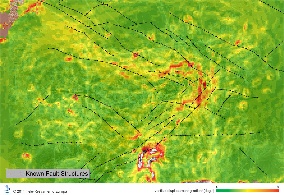
Figure 3: Vertical deformation gradients can be linked to fault and fracture systems. |
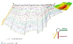
Figure 4: Surface displacement profiles can be linked to fault and fracture systems. |
Surface deformation monitoring can provide valuable information about the dynamic behaviour of reservoirs under production. Compacting reservoirs induce surface subsidence, as well as contraction.
Measuring these deformations can help to identify undepleted compartments, detect fault reactivation, mitigate risks associated with well failure, constrain geomechanical models, and aid field management decisions.
Compared to other techniques (e.g. GPS, optical levelling, tiltmeter), only satellite interferometry (InSAR) provides a full areal coverage for surface deformation monitoring with a measurement point every few meters, which is highly cost-efficient. The distance of neighbouring measurement points for all other techniques is in the range of hundreds to thousands of meters. Therefore, the actual measurements have to be interpolated in order to obtain a displacement field. This suggests that features with a shorter length scale might not be detected.
The availability of an analytical geomechanical model of the reservoir allows a translation of the surface deformation obtained by InSAR into information at the reservoir level, such as the pressure change map.
The availability of two components (vertical and horizontal) of the displacement field provides a significantly improvement of the quality of the parameter estimation at the reservoir level.
The comparison of the pressure change maps obtained from reservoir simulation and the estimations gained from InSAR data highlights a strong compatibility.
InSAR is an operational tool for measuring surface deformation with different applications in a variety of market sectors, including oil and gas.
SqueeSAR™ is the latest InSAR technique developed by TRE. It is at the forefront of technology, providing millimeter accuracy displacement for a variety of measurement points across wide areas.
SqueeSAR™ works with all radar (SAR) satellites currently acquiring or having acquired data in the past.
References
- Klemm et. al. Monitoring horizontal and vertical surface deformation over a hydrocarbon reservoir by PSInSAR, EAGE First Break, volume 28, May 2010
- Ferretti, A., Prati, C. and Rocca, F. [2001] Permanent Scatterers in SAR interferometry, IEEE Transactions on Geoscience and Remote Sensing, 39, 8-20.
- Vasco, D.W. & Ferretti, A., 2005. On the use of quasi-static deformation to understand reservoir fluid flow, Geophysics, 70, O13–O27.
- Raikes, S., Mathieson, A. and Roberts, D. [2008] Integration of 3D seismic with satellite imagery at In Salah CO2 Sequestration Project, Algeria. 78th SEG Annual Meeting, Expanded Abstracts, 27, 2856-2858.
- Vasco, D.W. , Ferretti, A. and Novali, F. [2008] Estimating permeability from quasi-static deformation: temporal variations and arrival-time inversion. Geophysics, 73, 37–52.
- Rucci, A., Vasco, D.W. & Novali, F., 2010. Fluid pressure arrival-time tomography: estimation and assessment in the presence of inequality constraints with an application to production at the Krechba field, Algeria, Geophysics, 75, O39–O55.
- Vasco, D.W., Rucci, A., Ferretti, A., Novali, F., Bissell, R., Ringrose, P., Mathieson, A. & Wright, I., 2010. Satellite-based measurements of surface deformation reveal fluid flow associated with the geological storage of carbon dioxide, Geophys. Res. Lett., 37, 1–5.
This page has no comments.