
EO data is used to validate Ocean General Circulation Models in order to determine which model provides the best representation of the real ocean in a given area. These studies provide data for design criteria needs as well as oil spill mitigation studies. In this case study, daily satellite observations of Sea Surface temperature and Sea Surface height data are used to determine which model is the best suited for circulation studies in Indonesia’s Banda Sea.
The lack of in situ data in the Banda Sea makes it difficult to gauge the quality of the model representation of 2D structures. As a result, it is often difficult to decide which model to use in a given region in order to get the best representation possible of the ocean. Here, two models are proposed for the representation of the same region, ITF025_G70 LEV, a regional model at ¼ degrees resolution and ORCA12, a global model at 1/12° resolution.
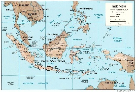
Figure 1: Map of the Indonesian seas
EO offers a unique possibility of evaluating the quality of models by comparisons with ocean observations at the Sea Surface. Here, 10 years worth of data is used to determine the mean monthly difference and the standard deviation for sea surface temperature fields and sea surface height fields (not shown). Monthly maps are then plotted as well as climate year time series in a specific area, namely in the Banda Sea.
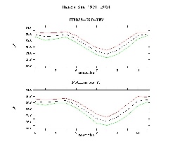
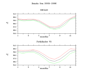
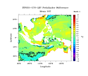
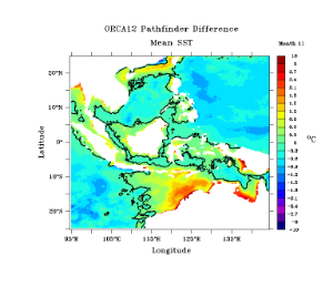
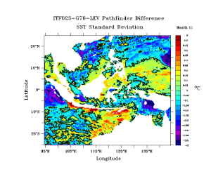
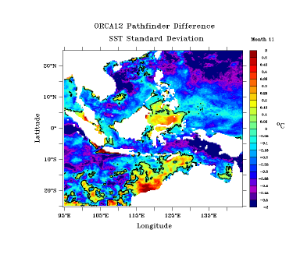
Figure 2: Upper panel: Yearly cycle Middle panel November mean difference, Lower panel: November standard deviation for ITF_025 (left hand and orc12 right hand side for surface temperature.
The analysis shows that the global model presents some marked biases in coastal areas even though generally, the differences with the satellite data are less than for the regional model. In the particular cases of the Banda Sea, the yearly cycle is better represented in the regional model with similar amplitudes and standard deviation. Similar results are found for the sea surface height data. The conclusion is that the regional model is of better quality over the Banda Sea.
EO offers thus a simple an effective way of providing zero order validation for numerical models. They can thus be used also in the tuning of such models, to insure that the parameters used allow the best possible representation of the oceanographic circulation in the region of interest.
Finally, these type of diagnostics can also be produced on a daily basis when a model is used for day to day operations such as the provision of a current forecast.
CLS has over 25 years of experience in delivering data and services to customers all over the world. With a staff of 470, in France and abroad, CLS offers services in environmental monitoring, maritime security, and management of marine resources to a broad range of professionals including government, industry and the scientific community, and maintains an operational center with expert support 24/7. Since 2001, CLS has developed services for the oil & gas industry based on its built-in expertise on data collection, radar imagery or numerical modelling. For the EO4OG Project, CLS leads a consortium composed of METEO GROUP and NERSC. Tullow Oil kindly supports the team as a consultant.
Contact
Dr. Marc Lucas, mlucas@cls.fr
This page has no comments.