Woodside Energy needed a dredge monitoring solution to satisfy regulatory requirements. Starting in October 2007, satellite based turbidity mapping offered a solution and operationally generated maps were delivered on a regular basis. The coastal water monitoring area is located in North Western Australia and water turbidity products were delivered on average every two days for more then two years for an area of 1000 sqkm. These data sets complemented the localised, point based environmental monitoring strategy of Woodside's PLUTO LNG development project with spatially resolved distribution maps. Dredging operations support new pipeline laying activities and the shipping channel expansions. The Service provider was Eomap GmbH. |
|
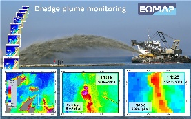
The large size of the required water quality monitoring area (~1000 sqkm) needed to be covered in regular intervals, allowing for a high frequency during dredging operations. The movements and size of the dredge plum had to be detected and quantified consistently in terms of turbidity with an adequate spatial resolution. The creation and fading of plumes, their potential impact on adjacent coastal areas, and the impact of natural factors such as re-suspension due to tidal currents and storms needed to be quantified for the environmental assessment. Conventional methods using insitu sensors of turbidity allow a point wise, vertically resolved measurement of turbidity and suspended solids, but not an area wide coverage with a clear classification of natural or man made turbidity sources. An increased number of insitu sensors would not only just increase cost, but also require regular maintenance and together with conventional airborne monitoring would increase HSE risks substantially. |
|
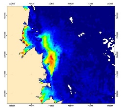
Satellite based monitoring allows a sustainable service provision without any direct HSE risks. Physics based retrieval algorithms ensure the consistent and operational generation of quantitative water quality maps. Additionally, flexible client defined temporal and spatial resolutions and back-up solutions can be implemented if satellite sensor independent processing technologies are applied. These requirements were fulfilled with the established EOMAP processing technology. Within the monitoring program, various other remote sensing sources were integrated for verification, using the hyperspectral airborne HYMAP sensor and the multispectral satellite sensors IKONOS, RapidEye, MERIS, MODIS Terra and Aqua. The product evidence shows consistent and well calibrated turbidity data, comprising spatial resolutions between 3 and 250 meters and a frequency of up to two records per day. On average every two days a quality controlled turbidity map from one of the MODIS satellites was delivered, in total over 420 scenes.
The minimum cost savings compared to an aerial monitoring solution were larger then 1 million AUD for this project. Reliable and robust quantitative map products avoided any delays in dredging operation, which in its cost impact is not being qualified, but could easily equal the same amount. In addition, HSE risks were avoided completely, since no field operations were required and no environmental impacts generated using the satellite monitoring solution.
Due to the direct cost savings the return of investment for this project is already a multiple. In addition, this new methodology can now be utilised at even lower cost for any future dredging projects in Woodside and a familiarisation of the satellite monitoring can lead to new mapping and monitoring solutions in unrelated areas.
Apart from the remotely sensed water turbidity products, additional optical satellite retrieved map products can complement the water quality services for various offshore applications. Examples would be water depth mapping and sea floor classification in shallow areas, as well as natural slick and oil spill mapping. Radar satellite monitoring offers additional information on sea surface parameters like ocean surface roughness, wave heights and swell frequency and direction.
The EOMAP technology is fully operational and standardized over various satellite sensors. It is currently implemented into fully automatically service provision chains, to allow near real time services and cost savings for clients. Project specific solutions can be accommodated.
-Reference : Hausknecht, 2010 (http://earth.eo.esa.int/workshops/gasoil2010/Hausknecht.pdf)
-Key words: Oil and Gas, Offshore, Dredging, Turbidity, Water Quality, Monitoring
-Service provider: EOMAP Ltd. / Germany
-User/ Customer: Woodside Energy Ltd.
-EO service: Operational long-term monitoring of turbidity using multiple satellite data (MODIS Aqua and Terra, IKONOS, RapidEye, HYMAP)
-Source:© 2011 EOMAP, Germany
This page has no comments.