Irrigated Crops Acreage Mapping
The service provides information on acreages covered by main land use classes in irrigated arable land per administrative and/or hydrological units. Products generation is based on the inversion of crop phenological models with statistics of biophysical parameters computed from medium resolution optical EO data. It is able to discriminate acreage for various groups of irrigated annual crops (e.g. summer herbaceous crops, fodder, rice, winter herbaceous crops).
Generally aimed to serve added value services such as water quality or water abstraction by irrigation, it is a basic piece of information to feed databases used for multi-purposes applications.
Based on 1 to 3 medium resolution optical data (MERIS) per month, a yearly update is operationally feasible on large areas. Minimum Mapping Unit should be at least 2 km².
Cross-checking with statistical information demonstrated a very good fit, up to 90% of correct thematic accuracy in Europe. Meteorological data (daily minimum and maximum temperatures measured on weather stations of the area, and geographic coordinates of weather stations) and agronomic data of local crops for each class of arable land use are needed for additional inputs. The non-arable areas (artificial, forest and seminatural, wetlands, water, agricultural non arable) are masked out on the map product. The mask is derived from a most recent high-resolution land use map (tentatively, maximum 5 years old, depending on the dynamic of land cover change over arable land).
While continuity of this particular service is guaranteed in the future by forthcoming sensors, with similar characteristics to the currently used ones (e.g. Ocean and Land Colour Instrument
(OLCI) aboard Sentinel-3 and PROBA V), future availability of new sensors providing more frequent global coverage at higher spatial resolution (e.g. Sentinel-2) promises an wholenew,
advanced version of this service with much improved spatial resolution.
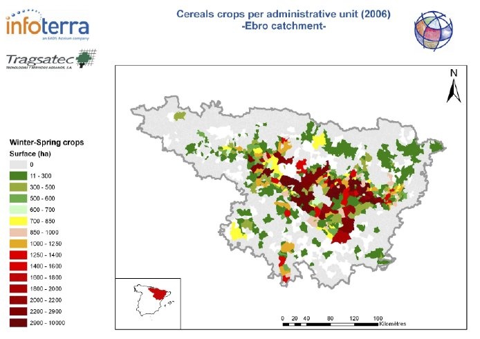 Irrigation surface on Ebro basin: irrigated cereals crops map. Credits: Tragsatec and Infoterra.
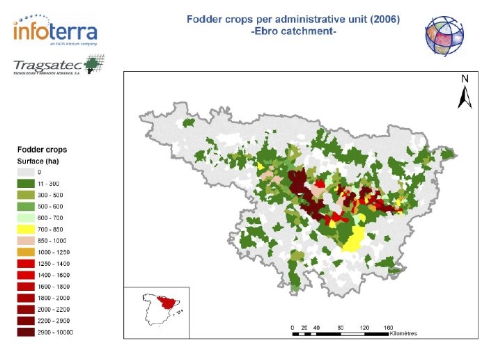 Irrigation surface on Ebro basin:fodder crops map. Credits: Tragsatec and Infoterra.
References:
ESA 2013, Earth Observation for Green Growth: An overview of European and Canadian Industrial Capability
Products | Source | Descriptions | Product Standards | Ref. Project |
|---|---|---|---|---|
Irrigation water maps |
|
|
| Topic | Description | Key Words | References |
|---|---|---|---|
This page has no comments.