On Earth, polar ice caps are made mainly of water ice and occupy about 7% of the area of the world’s oceans (1).
There are two main identified routes that cross the Arctic. The Northwest Passage runs from the Atlantic Ocean Through Baffin Bay Between Greenland and Canada, more than 1 500 kilometers along the coasts of Canada and Alaska, through the Bering Strait between Russia and Alaska, and then to the Pacific Ocean. The Notheast Passage has a double lenght, and runs from the Atlantic Ocean along the coast of Norway, Sweden, Finland and Russia to the Chukchi Sea and down to the Bering Strait as well, making it the bottleneck for both routes (2).
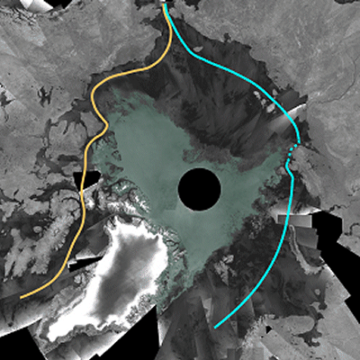
The melting cylce of the Arctic sea ice is characterised by a growing coverage surface each northern winter followed by a recession in summer. This is a natural phenomenont, but the rate of overall loss has been accelerating according to satellite records starting in 1978 (3). The Northwest Passage (orange line) across northern Canada appears fully navigable in the image beside, created through the mosaic of 200 images acquired by the ESA's Envisat Advanced Synthetic Aperture Radar in 2007. The same image shows that the Northeast Passage (blue line) along the Siberian coast remained only partially blocked.
2007 Envisat mosaic of Arctic Ocean (Dark grey areas represent ice free passages) © ESA
Exploration of the Arctic has been constrained by the melting cycle: ships have been often blocked or trapped by the freezing of ice in the Northwest Passage during wintertime. Countries and companies are interested in exploring the Arctic for scientific reasons, but also for shipping, oil and natural gas reserves, and gold and diamonds deposits. With the opening of that passage,probably due to climate change, but welcomed in terms of trade shortcuts, it become feasible to navigate through the Arctic. The way remains nonetheless a dangerous one which requires continuous monitoring for ships not to risk remaining trapped there: "ice, unlike most hazards to navigation, is an elusive, ever-changing danger" (2).
The overall economic and environmental impacts of new shipping ways through the Arctic have not yet been made clear: saving fuel and lower emissions have to be compared with maritime safety. Models predicting ice-concentration, thickness and movements of ice, such as those developed by the IRO-2 project (4) are needed for safe route planning. Forecast variables pertain to the ocean, atmosphere and weather domains, and come in large part from remote sensing satellite observations. They have to be included in the route calculations, considering the continuously changing position of ships. Buoys among the ice provide data on drift speed to be integrated with satellite measurements.
(1) http://www.rmg.co.uk/explore/sea-and-ships/in-depth/north-west-passage/the-science-of-arctic-melting
(2) Capt. K. Sweeney, Ice-free Arctic waters open up new opportunities and dangers, Professional Mariner 2009.
(4) http://www.cen.uni-hamburg.de/en/about-cen/news/2014_21_03_rv_lance.html


This page has no comments.