Applications
According to the Office for Coordination of Humanitarian Affairs, the number of reported disasters has increased significantly in recent years. Although some of this increase may be attributable to better reporting, the increasing exposure of people and property to natural hazards is playing a major role. TThe size of the group of refugees and the internally displaced people has increased in recent years, especially in Asia and sub-Saharan Africa. Population growth and other demographic changes, including rapid urbanisation, will continue to put pressure on resources for humanitarian assistance and will require changes to the way it is provided. Disaster prevention saves lives and livelihoods and has been proven to be more cost effective than humanitarian response. (1)
Data issues cut across all activities in all of the humanitarian crisis phases. The international community is increasingly concerned about the number of humanitarian crisis situations and the growing number of populations affected. As stated in the Guidelines on Data Issues in Humanitarian Crisis Situation (2), data is increasingly required during the preparedness phases for contingency planning, vulnerability analyses and baseline indicators; during the acute phases for preparation and targeting of response to make an impact; during the chronic phases for short-term humanitarian-oriented programme design and delivery, monitoring and evaluation, as well as during the postcrisis phases for programming reconstruction. Over time, improved assessment of impacts and responses through better data collection and management contributes to more complete global databases on disaster impacts, leading to better risk assessment and targeting of prevention and preparedness activities.
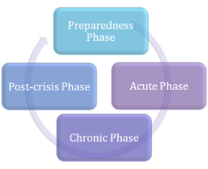
The different phases of humanitarian crises.
Monitoring of settlements through satellites
With small and fragmented spatial and spectrally heterogeneous characteristics, the accurate mapping of human dynamics and humanitarian movements still remains a challenging task. A number of satellite remote sensing systems collect relevant data which have then to be analysed for products derivation and refinement in a multiscale context. Continuity in Earth observations is essential (3). Better mapping of human settlement is a key step in the improvement of crisis management operations. Information about population is one of the crucial area to be covered: population density and distribution data help in more effective organisation of humanitarian operations. The Joint Research Centre of the European Commission has for example developed the Global Human Settlements Layer (GHSL), based on authomatic analysis of medium resolution satellite data. A fast and precise mapping of built-up areas, toegether with ICT technologies, makes the process rapid and efficient, able of dealing with heterogeneous satellite data on a global scale. The GHSL will help to improve the quantification of the building stock which is valuable information both for risk assessment activities and for emergency rescue operations. As the building stock is an indicator of human presence, this critical piece of information on population (often lacking in remote areas) can help the first responder communities to focus their efforts in a particular area.One of the major problems in disaster-struck areas in less developed countries is the lack of relevant and up to date pre-disaster information that can help to quickly locate and assess the type and extent of damage, especially in populated places. The combined use of better spatial resolution satellite data and of an automatic pattern recognition algorithm means that massive datasets can be processed more efficiently and rapidly than ever before. It also allows regular monitoring of the changes in the patterns of human settlement landscape anywhere in the world (4).
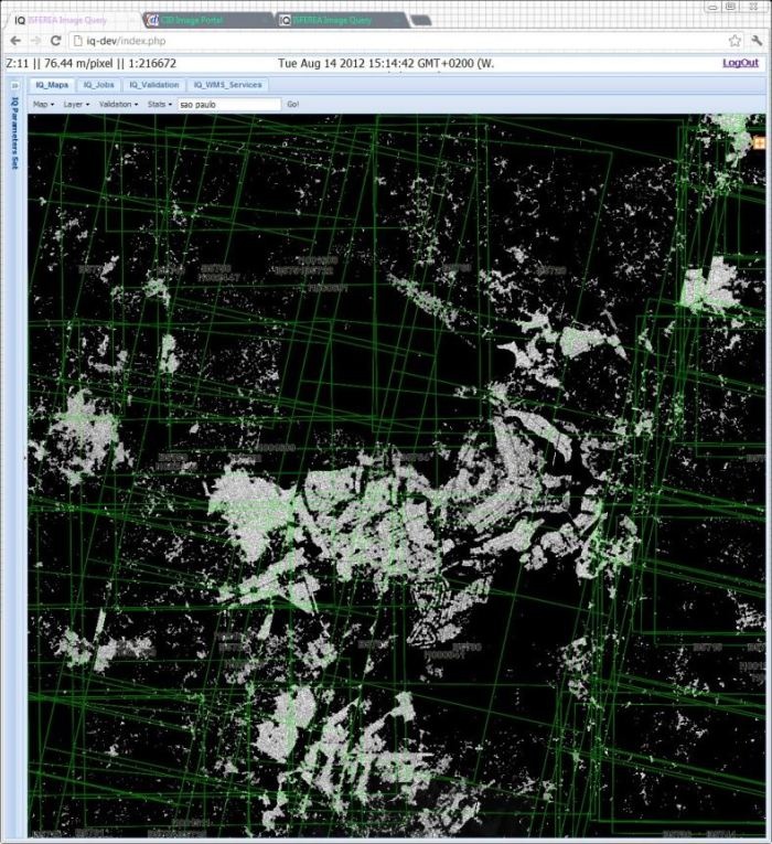
City of Brasilia: the ``presence of buildings'' GHSL layer represented at 1:50K scale with the footprints of input scenes (CBERS 2B) in dark-green . CREDITS: JRC
The G-NEXT project, which prepares the pre-operational phase of the EC Copernicus Security Service, also has a Camp Analysis and a Camp Monitoring Analysis component. Comparing the differences between satellite images at two points in time, it shows the location, extent and nature of changes in the temporary dwellings situated in politically or environmentally unstable regions. The changes of IDP and refugee camps are monitored during crisis over a longer time period, with a higher number of newly acquired images. These services are delivered for the operations of the European External Action Service. (5)
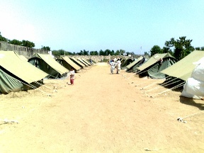
A camp for displaced people. CREDITS: Amam camp
References
(1) OCHA, World Humanitarian Data and Trends 2012
(2) UNFAPA 2010,
(3) Gamba P., Herold M., Global Mapping of Human Settlement: Experiences, Datasets, and Prospects
(4) http://ghslsys.jrc.ec.europa.eu/
(5) http://externalaction.security-copernicus.eu/projects-overview/g-next/g-next-nutshell
Products | Ext. Source | Descriptions | Product Standards | Ref. Project |
|---|---|---|---|---|
|
|
|
|
|
|
|
|
|
|---|---|---|---|
|
|
|
|
Topic | Description | Keywords | Reference |
|---|---|---|---|
Awareness Article | Monitoring and mapping the conflict in Iraq (Deimos Imaging) | conflicts, heritage, environment, camp | eomag |
This page has no comments.