
When selecting a site to place the drilling rig or perform maritime operations, it is essential to know all the metocean characteristics, including local and regional statistics.
Surface wind information directly derived from SAR images can be a good source for enriching local and regional statistics to facilitate site studies.
In this case study, the wind conditions off the coast of Syria were analyzed by CLS and the end-user acquired complete knowledge of the wind conditions in this area.
When deciding if an area could be a good place to locate an O&G platform, O&G operators must consider the wind conditions over the zone. If an area is too prone to very high wind speed or very varying wind directions, it could mean the platform installation would be difficult or would complicate to ensure the safety of marine operations.
For this site study, CLS has used its large SAR archive, acquired by ASAR instrument aboard ENVISAT satellite (which is no longer functional).
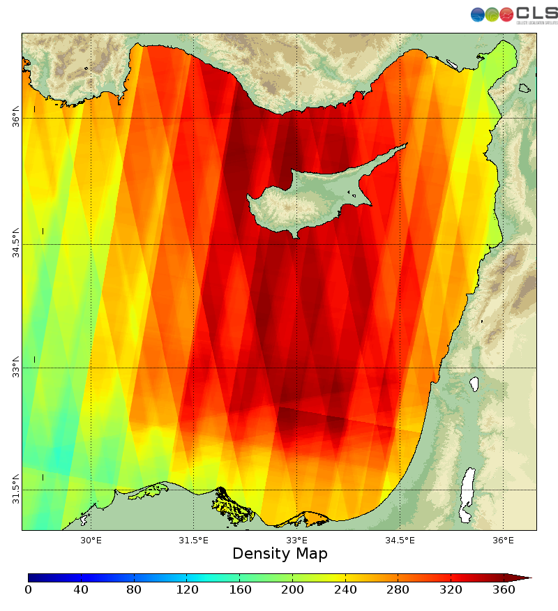
Figure 1 : Density map of SAR images used over the area
From each of the SAR image collected, the 10-m high wind information was extracted.
To better assess the wind conditions over the Syrian coast, CLS conducted a regional analysis following this principle:
- Results from a low resolution atmospheric model are analyzed over years to establish the most probable wind regimes over the area.
- Each SAR wind measurement at high resolution is associated to a low resolution wind regime.
- High resolution wind measurements are combined by regime in order to estimate the mean wind field (or other statistical parameters) at high resolution over the area.
This study led to the highlighting of 7 main wind regimes off the Syrian coast. Two of these 7 regimes are shown on the figures 4 and 5.
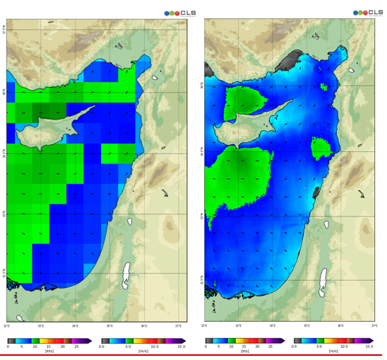
Figure 2: Regime 1: 52,04%
Left: surface wind model results; Right: SAR-derived surface wind results
The first regime over the area is likely to happen at 52.04%.
On Figure 4, despite their different resolution, one can observe the SAR wind measurement and model output are in good agreement.
However, on figure 5, high resolution features depicted by the SAR appear essential for the correct estimation of the surface wind conditions over the area.
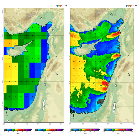
Figure 3 : Regime 5: 3.99%
Left: surface wind model results Right: SAR-derived surface wind results
The high resolution SAR images show very high speed wind regions located near the coast which are note visible on the model output because of their inability to resolve fine scale phenomenon impacted by the topography.
This information is of a great help when considering the location of the platform, and in that case the model alone is not sufficient to meet this requirements.
In parallel of the regional analysis, some locations were selected to perform an wind regime analysis, using a so-called virtual buoy methodology: all the wind speed and direction measurements are collected at points of interest to derive on the wind statistics. Thereby, the virtual buoy approach avoids the deployment and maintenance costs of an in situ buoy.
For each selected location, the estimated wind rose provides a succinct view of the wind speed and direction distribution.
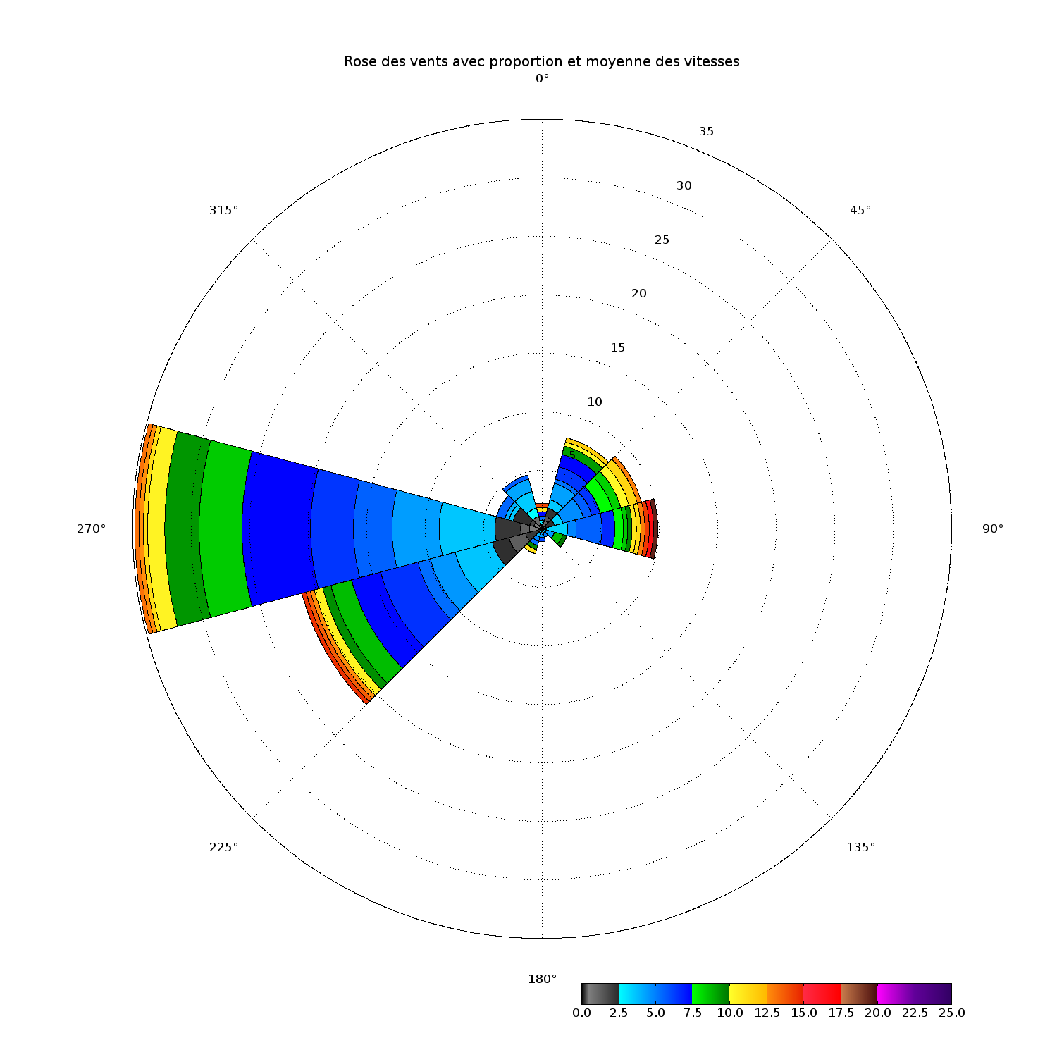
Figure 4 : Example of wind rose
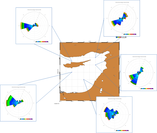
Figure 5 : Wind roses at the 5 points selected off the Syrian coast
This type of tools is of a great help when deciding on which coordinate to locate the drilling ring. To know the probability of high wind speed as well as its direction is an essential parameter to take into account during the site survey.
In this case study, we show how the SAR-derived wind information could be of a great help when selecting a place for an O&G platform.
The advantage being that the SAR archive is available all over the world and in large quantities making the statistics possible.
Thanks to new satellites like Sentinel-1, this SAR archive volume keeps increasing, as well as the data quality and resolution.
Besides, the wind information being nearly instantly extracted from SAR images, they are also of a great help for operations at sea to quickly estimate the meteorological situation in real time over a platform location.
CLS has over 25 years of experience in delivering data and services to customers all over the world. With a staff of 470, in France and abroad, CLS offers services in environmental monitoring, maritime security, and management of marine resources to a broad range of professionals including government, industry and the scientific community, and maintains an operational center with expert support 24/7. Since 2001, CLS has developed services for the oil & gas industry based on its built-in expertise on data collection, radar imagery or numerical modelling. For the EO4OG Project, CLS leads a consortium composed of METEO GROUP and NERSC. Tullow Oil kindly supports the team as a consultant.
Contact
Dr Romain Husson, CLS Brest, rhusson@cls.fr
This page has no comments.