Wastemon project is financed by ESA (European Space Agency) within the VAE program (Value Adding Element, former EOMD). The consortium is lead by ERA Maptec and involves Planetek Italia and EBA Engineering Consultants. WASTEMON project is aimed to supply services that can support the activities of waste monitoring.
A waste mapping and monitoring service to improve waste management practices and to detect illegal landfills using satellite Earth Observation data is tested by the Environmental Protection Agency of Puglia region and by Conversano, a small town located in Puglia.
Worldwide, increasing waste levels are becoming extremely complex to deal with and waste management is one of the most critical environmental concerns that modern society is facing. Recent international and national regulations are indeed trying to establish sustainable systems that prevent or reduce the adverse effects of waste processing or disposal on the environment.
These all-embracing characteristics make space-based Earth Observation a key tool for the monitoring and management of a wide variety of issues related to waste management.
The Wastemon project provided key support for some waste management practices using space-borne remote sensing images.
According to the EU Waste Framework Directive (European Directive 2006/12/EC), waste is defined as “any substance or object the holder discards, intends to discard or is required to discard”.
Waste may be broadly classified in three ways:
Hazardous waste that usually meets one or more of these four characteristics: ignitability, corrosivity, reactivity, or toxicity;
Non-hazardous waste;
Inert waste
Waste can be disposed of in a number of ways, including landfill, incineration, recycling, mechanical biological treatment (anaerobic digestion and/or composting), pyrolysis and plasma arc gasification.
The management for non-hazardous residential and institutional waste in urban areas, including collection, disposal and planning aspects , are usually the responsibility of local government authorities.
At the national level, EU legislation (through Council Directive 75/442/EEC on waste) requires each Member State to draw up one or more waste management plans in compliance with relevant EU directives, which are implemented by regional or local authorities. Each individual Member State has the duty to apply the principles of these directives when implementing a national waste management system.
The “Ronchi” decree (Waste Management Act 22/77), published in February 1997 and the subsequent revisions of this Act, regulated the management of waste in Italy at the national level, forbidding uncontrolled landfills and stipulating that every region must have a waste management plan. Despite the EU directive of 1999, which limited the use of landfills, this practice remains the main method of waste disposal in Italy.
The project offers waste mapping and monitoring services aimed at improving the environment, protecting human health and increasing efficiency in waste management across Europe and Canada. The services are based upon the use of remote sensing satellites coupled with the expertise of scientists.
Wastemon is based mainly upon very high-resolution applications, hyperspectral and thermal satellite imagery, and to a lesser extent on differential interferometric synthetic aperture radar (InSAR). These technologies are applied to filter areas with potential buried and surface waste as well as monitoring active landfill sites.
Following analysis of user requirements and business opportunities for EO data in waste, the following four services are offered:
Service 1A – Detection of sites with potential buried waste
Service 1B – Support for in-situ investigations and monitoring of sites known to have buried waste
Service 2 – Detection of sites with potential surface waste
Service 3 – Mapping active landfills
Planetek Italia has implemented some of the aforesaid services by developing products for a municipality located 30 km south-east of Bari in Puglia Region (south Italy).
The WorldView-2 VHR images taken in April 2011 which included multi-spectral and panchromatic bands were selected. The user provided the updated land-use map issued in July 2011, as ancillary data useful during the next step, and an ortophoto taken in 2006.
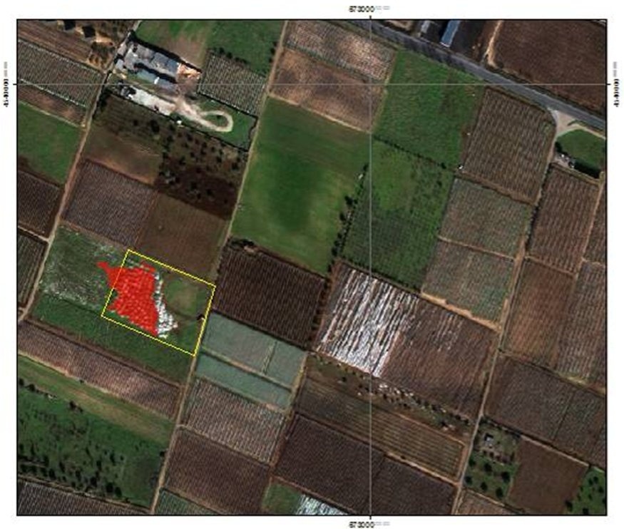
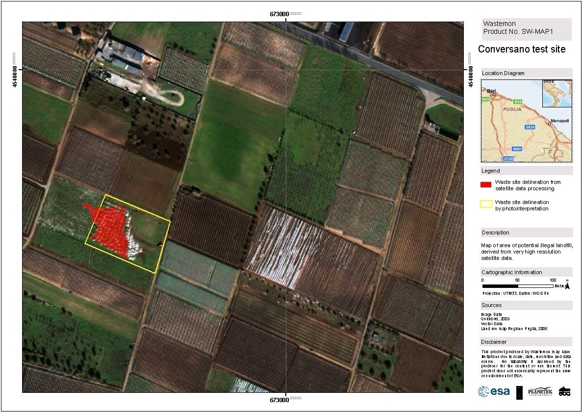
An object-based classification was performed on the basis of the spectral response of the sample area waste sites. The result was a preliminary land-cover map that identified potential illegal waste sites. The land-cover information and the road-network was used to filter out such preliminary results, building a sort of probability map based on selective criteria such as distance from the road network of less than 100m; distance from existing landfills, etc. The co-occurrence of the parameters related to the previous criteria makes the probability of finding illegal sites very high and allows the confirmation of the waste sites mapped from the preliminary EO data processing.
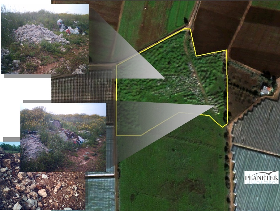
A first validation check was performed by on-screen qualitative analysis on the basis of the VHR image available over the area of interest (WorldView-2 image and ortophoto). Then a field-survey was performed in order to assess the plausibility of the output result. Figure 2, which shows images taken during the field survey, confirms the occurrence of illegal waste sites. Over 10 potential illegal waste sites were mapped in the area of interest, and a sample of 5 sites were selected to be visited physically. The field survey confirmed the occurrence of illegal waste sites in 4 of these therefore resulting in an accuracy of 80%.
Users
The Italian end user organizations involved in the Wastemon project are in charge of environmental monitoring both at regional scale (ARPA Puglia) and at local scale (Apulian Municipality, Urban Planning Office).
At the end of the testing activity, the resulting products have been delivered directly to the local user, the Urban Planning Office of the Apulian Municipality in order to collect the first impression on the quality of the output.
The user showed great interest in the results, assessed it as a useful source of support for their current cartography updating and to complete the understanding of their local land evolution. The satellite-derived product has been evaluated as an effective way to optimise the traditional monitoring activity and a complementary instrument to face the even more frequent phenomena of illegal exploitation of land resources.
In fact, after the delivery of the waste map, the Apulian Urban Planning Office started with a field campaign aimed to check the reliability of the information provided to proceed with legal actions in case of confirmation. The field checks have been performed by the police authority in charge of environmental monitoring. As a result, the information detected by remote sensing has been confirmed and some legal actions have been placed for the confiscation of those plots of land where a waste site was detected.
The success case in Puglia, is testified not only by the legal measures taken by the local authorities but also by the great echo of the news published by the local newspapers, highlighting the importance of the information extracted from satellite data analysis for the local authority and the real possibility to be fully integrated into their land monitoring activity.
The final results have been evaluated as a very useful tool to take operative and strict decisions in a faster, more accurate and economic way. Moreover, the perfect integration of the final products into the user’s working systems, allowed the customer to further appreciate the results and to better understand the potential of Earth Observation data.
Service provider


This page has no comments.