Success Story on the use of EO to protect property and save lives through improved flood warnings near ice-bound rivers.
Each year, the formation and break up of river-ice around the world can cause extensive damage due to flooding. In the town of Badger, situated in the Province of Newfoundland and Labrador in Canada, in 2003, the ice-built up to such an extent that severe flooding caused many millions $ damage to homes and property. Since then, the use of satellite radar imagery (Radarsat 1& 2, Envisat and in future Sentinel 1) has led to improved monitoring of the ice build-up and consequently flood warnings are improved allowing citizens to move and protect their property. The success in Badger has led to this technique being used for other rivers in Canada, USA and in Russia.
Furthermore, the products developed to support the improved flood warnings are now also used by emergency services for planning of responses, by the operators of hydro-electric projects to improve resource management and by engineers for design work.
As a further benefit, the sustained observations are available to look at longer term effects and particularly the impact of climate change as well as being available for research and development into flood relief and other local planning schemes.
The Water Resources Management Division of the Newfoundland and Labrador Department of the Environment and Conservation is the provincial authority responsible for providing flood warnings based on the information derived from the satellite data and their model. They also make the ice products available for use by others.
Project Background
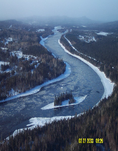
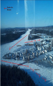
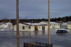 The "Badger flood" in 2003 caused $10m of direct damage to the town of Badger; a community of 1,100 inhabitants. It is situated in the centre of Newfoundland island at the confluence of 3 rivers of which the largest is the Exploits river. On 14th February 2003, no flood was indicated by the historically observed, ice behavior, yet on 15th February the river level rose 2.3m in 1 hour and large chunks of ice were pushed into the town. The damage caused was extensive and led to parts of the town being moved and re-constructed. As a result, ways were looked for with which to improve the forecasting of floods without causing extensive false alarms. The Water Resources Management Division had been using an ice-progression model to predict when the river would freeze and when jams would occur (often because of frazil ice slush being carried downstream). The general inaccessibility of the river banks and the large areas to be surveyed meant that a remote sensing system is needed; and the Water Resources Management Division turned to satellites to help.
Flood forecasting for rivers like the Exploits at Badger has especially been a challenge due to the complexities of modelling ice formation and breakup in real time in an operational context. This has been further complicated by the effect of climate change which has changed historically observed and studied ice cover formation behavior.
The enclosed nature of the river system (inaccessible river banks) and the large areas to be covered means that using synoptic imagery from radar satellites allows defficiencies in the model to be overcome as well as providing robust improvements as the underlying conditions change due to climatic effects. The area needs to be observed every few days during the winter meaning that satellites provide an effective solution. The use of helicopters or manned observations would be an expensive solution that would be restricted by weather conditions and daytime hours. radar satellites provide all weather coverage at all hours of the day.
The Water Resources Management Division therefore worked with the local EO services company C-Core to develop a solution based on the use of Radarsat imagery which was provided by the European Space Agency and the Canadian Space Agency. This was supported under a project, Polarview from the European Space Agency as part of a programme to prepare service elements for GMES (now Copernicus).
The river ice service uses satellite RADAR imagery from the ENVISAT, RADARSAT and RADARSAT 2 polar orbiting satellites. It is used to augment and enhance a modelling and traditionally ground observation based flood forecasting service for Badger that uses a computer simulation model for simulating ice conditions on the Exploits River next to Badger. This was the first integration of RADAR imagery into operational flood forecasting of river ice in the world. The river ice service is now used on several rivers in Canada, United States of America and Russia.
The satellite data is acquired and rapidly delivered to the processing centre where it is analysed and interpreted to generate 3 products; the location of the ice front, an ice classification map and an ice change map. These products are delivered to the Water Resources Management Division which has set up an ice monitoring service. This service delivers flood warnings as well as making information available to other users in the area. The first 2 of these products are also made available through a web-site where local citizens are able to see and interpret the information for themselves.
The three products generated are:
- An Ice front map showing the location of the ice front on the river.
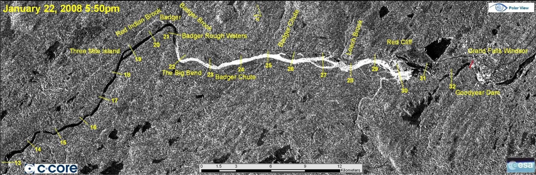
2. An Ice Classification showing the types of ice at various river locations:
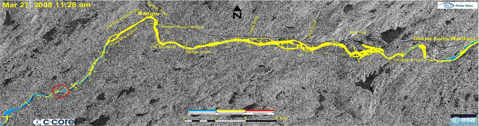
3. An Ice change map
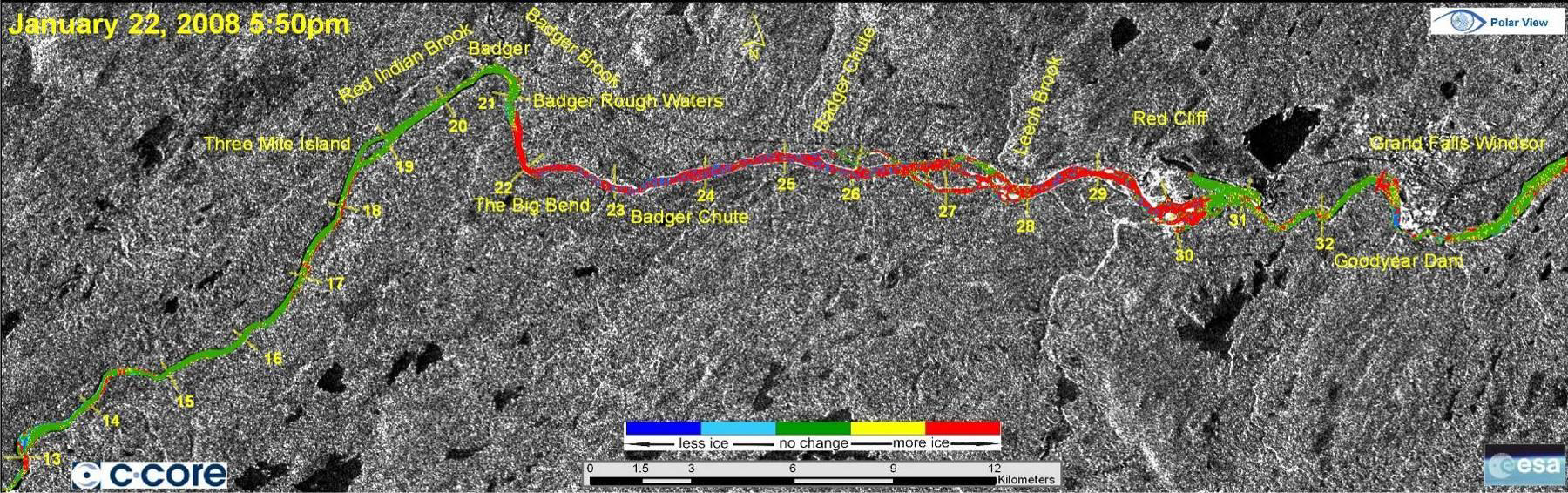
These products are used as inputs to the ice model providing information which would otherwise not be available.
The result has been very successful in the Badger area such that it has now been extended into other rivers as well.
Firstly, the improved warnings are allowing citizens of the town to better prepare themselves against the future floods by moving vehicles onto higher ground and moving furniture and other property / valuables into safer locations.
Secondly the direct savings to the Water Resources Management Division is significant with the use of satellite data replacing helicopter flights and the need to send people to gather the information. The cost and the frequent updates required rendered this method almost impossible in any case. Each helicopter flight costs around $5k and with around 35 flights (one flight for each image) needed each year the total cost would be over $100k.
Thirdly, the value gained by the community in having access to better information.
Fourthly, the emergency services which are placed on stand-by as soon as a warning is given are able to operate more efficiently with fewer false alarms and better targeted information when it is needed.
Fifthly, the operators of a hydro-electric dam upstream on the Exploit river are able to use the same products to achieve better management of water levels in the winter since they are able to observe the ice-build-up more directly and frequently; using the information to provide real-time feedback.
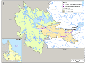
Sixthly, the engineers designing a new hydro-electric project on the Churchill River in Labrador are able to take advantage of the ice information directly during the design process as well as planning for it once the project becomes operational.
Overall the economic value of the application is significant and the use in a number of other rivers in Canada, USA and Russia provide even more economic value to this application.
- About PolarView: Polar View offers integrated monitoring and forecasting services in the Polar Regions, as well as mid latitude areas, affected by ice and snow. Using satellite earth data, in combination with a number of sophisticated models and automatic tools, the satellite images are converted into produce that graphically illustrate the characteristics of the ice and snow on any given day. For the first decade of its operation, Polar View was a project supported by the European Space Agency (ESA) and the European Commission, with participation from the Canadian Space Agency, under the Global Monitoring for Environment and Security (GMES) programme. In order to carry forward the significant momentum generated by Polar View and facilitate the continued collaboration of its members within a formalized network, Polar View was formally incorporated under the name Polar View Earth Observation Ltd. in the UK as of October 28, 2011. More info
- About C-Core: C-CORE is an independent not-for-profit R&D corporation that creates value in the private and public sectors by undertaking applied research and development, generating knowledge, developing technology solutions and driving innovation. Established in 1975 as the Centre for Cold Ocean Resources Engineering to address challenges facing oil & gas development offshore Newfoundland & Labrador and other ice-prone regions, C-CORE is now a multi-disciplinary organization with world-leading capability in Remote Sensing, Ice Engineering and Geotechnical Engineering. More info
- Department of Environment and Conservation Government of Newfoundland and Labrador
This page has no comments.